9 Wildfire
Threat Assessment
Climate change is forecasted to increase the likelihood of “very large fires”, which are the largest 10% of wildfires that burn the majority of the land area in the United States. This is primarily due to the lengthening of fire seasons with the overall rise in temperature. The United States National Oceanic and Atmospheric Administration (NOAA) predicts that by 2042 in the Great Plains and Northwest portions of the fire-prone Western US, the number of weeks that a very large fire could occur will go up between 400-600%! In other areas of the Western US, it still goes up between 50-400%[1]. You can bet that if fire season is lengthening within the Western US, then it is also lengthening in other analogous climate zones throughout the planet.
Much of the most important work of mitigating this threat is in the initial assessment phase, and ideally would be on the permaculture practitioners mind at the time of site selection. If a location sits within an area with major fire danger, and a design site is located within topography and vegetation types that will inevitably burn someday, then it will take a huge amount of infrastructure planning to avoid the threat. Sometimes the best defense is a good offense, and selecting a location that is not in an area with extremely high fire danger could be the best choice to make. So that being said, this next section will look at assessing the threat and mapping the “fire shed”.
Wildfire Season
The first thing to do is assess the time of year that is most likely for a wildfire to spread. As stated above, with rising temperatures, fire seasons are expected to lengthen very significantly in some areas. Fire season is when the confluence of heat and moisture is at its highest; the greater the heat and the lesser the moisture, the greater the fire danger. Fire season in many areas is also determined by critical weather events, such as seasonal downslope winds, or periods of dry lightning strikes. Fire season also has a typical end date, when fire spread is no longer likely or possible due to temperatures, day length, relative humidity, and weather patterns. There are also fire stopping events, like significant rain, which can abruptly put an end to the season[2].
Mapping out the fire season therefore becomes an equation. The “Fire Behavior Field Reference Guide” put out by the National Wildfire Coordinating Group breaks fire season assessment into 5 primary elements: climatology, fire activity, critical weather events, fire slowing or stopping events, and fire growth potential indicators.
In ‘climatology’, each season is assessed for its temperature, precipitation, and relative humidity. A seasonal narrative is produced for the year which identifies the weather patterns that bring on the start and end of fire season.
In ‘fire activity’, a narrative is produced that describes fire’s response to the seasonal conditions that are described in the ‘climatology’ section. When and why fire season peaks, and why it dissipates are addressed in this section.
In the ‘critical weather events’ section, any weather systems that set up the start or intensification of fire season are described. This often includes a katabatic or downslope wind. These winds are often named, like the famed Santa Ana winds in Southern California that roar over the mountains from the East, down into the coastal basin, bringing strong hot wind from wooded mountains into human settlements located in the urban-wildlands interface.
For ‘fire slowing or stopping events’, this is also signified by a weather event. This weather event is also often a change of wind direction, influx of precipitation and humidity, as well as cold air.
The ‘fire growth potential indicators’ are particular measurements that signal the start of or intensification of fire season. In the United States, there are a number of different measurements done by weather monitoring organizations like the US drought monitor for example. Other examples are given below in this sample fire assessment given for the Northwest. Similar assessments for all fire prone regions of the US can be found here[3]:
Northwest
Climatology
- Winter/Spring – Cool & moist with frequent & abundant precipitation, especially western portion of area. Relatively dry east.
- Summer – Some windy & dry season potential early, then becomes generally warm & dry with infrequent wind events due to dry cold fronts.
- Fall – Return of cooler, more moist conditions ushered in by a period of windy, dry conditions with cold frontal passages. Potential for dry offshore wind events behind storm systems.
Fire Activity
- Fire activity peaks in summer due to increasingly warm & dry conditions and potential for wind and lightning with dry cold frontal passages.
- Rapid decrease in activity in fall with Pacific moisture on the increase, though this the peak period for dry offshore wind events and a few dry cold front passages are still possible.
- Little to no activity late fall through spring
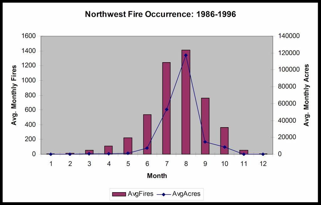
Figure 57: Northwest Fire Occurrence: 1986-1996
Critical Weather Events
- Thermal Low/Subtropical Ridge
- Breakdown of the Upper Ridge and Passage of a dry cold front
- Foehn or Downslope Wind (East Wind west slopes of Cascades and Chinook Wind east slopes of the Cascades)
Fire Slowing or Stopping Events
- Closed Lows/Wet Cold Front
- Marine Layer/Onshore flow
- Smoke Events
Fire Growth Potential Indicators
- Energy Release Component
- 100 hr fuel moisture
- AVHRR satellite NDVI DA and RG
- NWS QPE (30-60 days)
- Drought Monitor
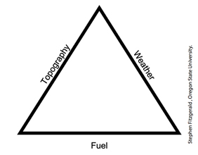
An important permaculture principle to revisit right now says that we design from “patterns to details”. The fire season is the larger pattern of assessing fire danger for a region. As we move in closer to examining and assessing the danger for a particular site, we move to another tool which is the fire behaviour triangle. The three sides of the triangle are topography, weather, and fuel.
Topography
There are several elements to consider in assessing the fire danger based on topography. Those are slope, landform, and solar aspect.
The steeper the slope, the faster a fire can move, as it preheats and pre-dries the terrain above it. Fire typically moves up, so looking downslope from a location is a good first step in estimating where a likely fire will come from.
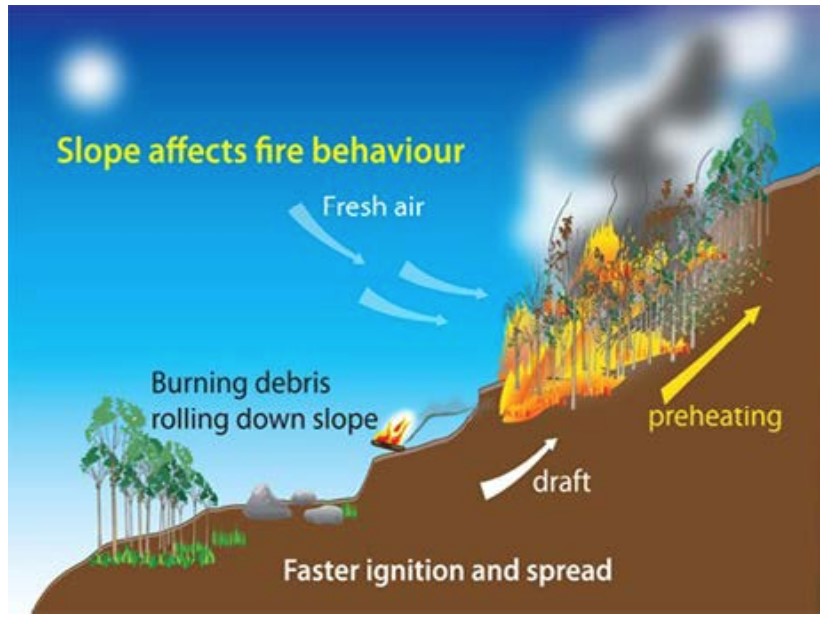
Landform also has a lot to do with the potential spread of fire, as topographic features like a canyon or drainage can create a funnel for fire to move through at an accelerated speed. A “chimney”, which is a canyon or drainage can serve as a pathway for fire to move both up and down slope, depending on wind direction. We cannot just look at topographic features without overlapping with the other sides of the fire behavior triangle like weather and fuel.
Solar aspect is another topographic element that overlaps on the triangle with vegetation. A slope with greater solar exposure, like southern and western slopes in the northern hemisphere, will be drier because of the increased solar radiation. A drier slope will be more flammable, so you can make assumptions about the potential fire behavior on a slope based on it’s directional orientation.
Weather
The whole ‘fireshed’ assessment activity becomes somewhat of a process of elimination. The first thing that was examined was determining the fire season, where parts of the year where conditions are not conducive to the spread of fire can be eliminated from planning. Next we examined topography and the slopes, aspects, and landforms where fire is more and less likely to spread quickly, where certain areas can be eliminated as hazardous. The next piece to look at in our process are several aspects relating to weather.
Weather has to do with a number of factors including wind direction, wind speed, temperature, humidity, and critical weather events. Each factor within the weather heading has a seasonal association, and some weather patterns can be eliminated as having any relation to determining fire risk due to their seasonal occurrence. We really want to examine the wind direction, speed, and temperature during the fire season.
It was mentioned that fire season is set to lengthen in many areas of the world. Will the lengthening fire season begin to overlap with wind patterns that are not typically present during fire season? That’s impossible to say right now, but that possibility should be considered in the name of precaution.
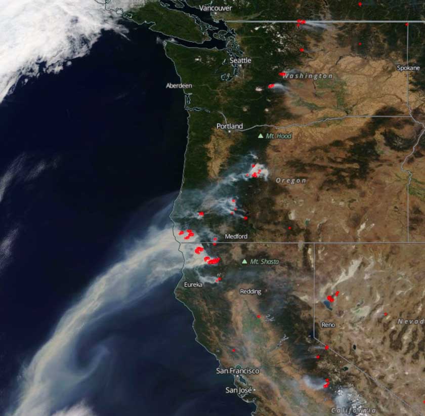
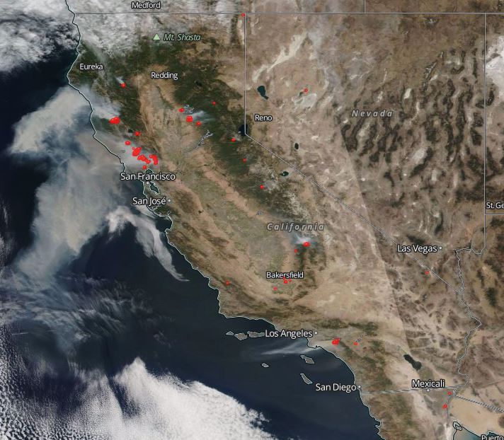
It’s really interesting to look at satellite images of the direction of wind driven smoke during periods of greatest spread of regional wildfires. This image from September 1st, 2017 is really informative to the nature of hot continental air moving from the northeast and creating a general Katabatic downslope fire situation that was extremely explosive in the region:
The same goes for the catastrophic fires in Northern and Central California in October of 2017.
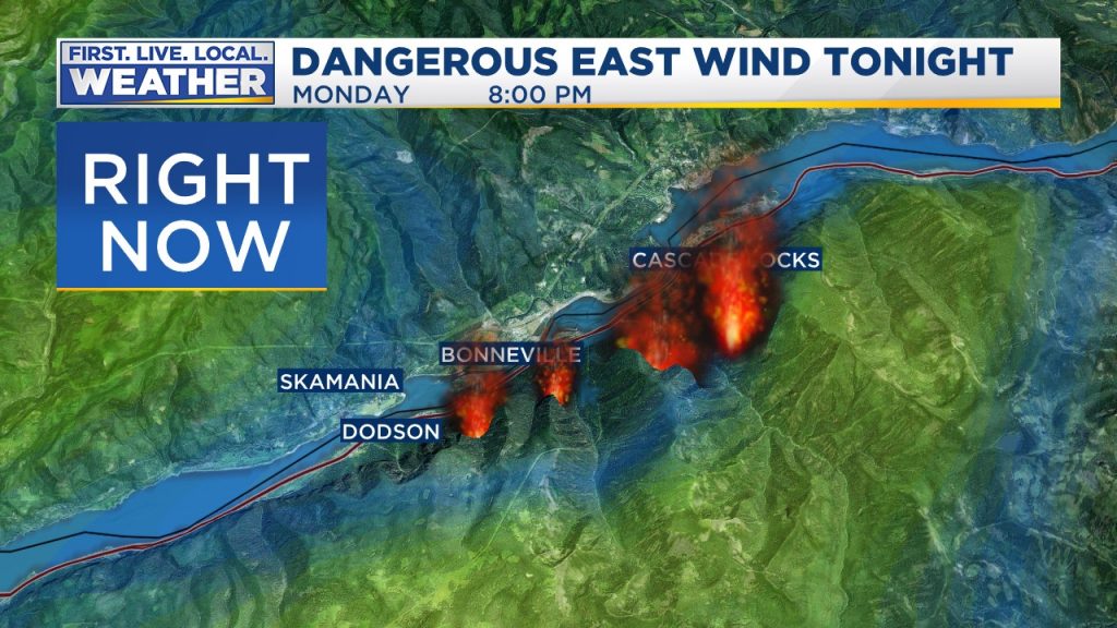
The Eagle Creek fire that occurred in the Columbia River Gorge in Oregon in the summer of 2017 was a perfect example of where topography and katabatic wind combined to funnel the fire through the gorge at an explosive speed.
The big question is what are the likely wind directions during the height of fire season? When the unlikely wind directions are taken out of the equation, then we are left with likely wind directions, the fire season, the most likely topography for carrying fire, and then finally an assessment of the fuel as the third side to the fire behavior triangle.
Fuel
Fuel is the actual agent of how fire moves and spreads. Regardless of how aligned all of the other factors are, fuel continuity ultimately determines the transmission of fire through the landscape. From a design perspective, fuel is the piece of the fire equation where we have the most leverage. Once you have a specific site you’re working with, you won’t change the fire season, topography, or weather. But you can alter the fuel load relatively easily in many cases. The first step is assessing the existing fuel conditions.
For many people who have studied ecology, the horrendous fuel conditions in areas like the conifer forests of the Western United States are daunting. One-hundred-fifty years of fire suppression combined with overgrazing have created much more dense stands of vegetation then ever existed when there were regular cycles of fire that cleared out underbrush and small trees, leaving stands of large stately trees with clearings and an open understory of diverse low and mid-sized species. The conditions in many areas are now of dense stands of smaller trees, with ladders of vegetation leading from grasses up to shrubs to dead low branches and into the closed dense canopy. This represents a continuity of fuels from the ground level all the way up into the tree canopy, and this is what we are primarily trying to avoid when protecting a site from fire. Once a fire enters the canopy, it can become much larger and harder to put out.
In chaparral regions, many species require fire for their germination, and exist in extremely thick stands with lots of dead wood due to suppression of cyclic fires which keep the fuel load down and space between stands.
In Oak woodlands, it is the same, with thick woody understories and ladder fuels leading from dry grasses up into woody canopies. These are the types of ecosystems that have shifted into very hazardous places to be during fire season in this age of rising temperatures and erratic rainfall patterns.
Many areas in the wet-dry tropics also suffer dangerous fire seasons, and the issues are basically the same in assessing the potential spread of fire through the ecosystem. Especially in tropical climates with warm wet periods, the growth of grasses and leafy material that then dry out become a dense flammable layer.
Human development has also crept farther and farther into the edges of fire prone ecosystems, into an area we call the urban wildlands interface. This only adds fuel, in the form of houses, propane tanks, sheds, fences, firewood, and all the flammable materials we accumulate in our surroundings. It also adds breaks to the spread of fire in the form of roadways, ponds, lawns, orchards and more, and in the section on design, we will look at how to position those elements in relation to the likely direction of wildfire in order to mitigate the risk.
Assessing the fuel load of a site or region can start with looking at a satellite map and examining the density of vegetation in every direction and how directly it leads to your location from outside. This is where the work done of assessing the likely wind directions and slope steepness and solar aspect will guide which slopes to look at.
Is there a continuous band of fuel coming at your site, and where is that band of fuel connected to? Even if the band of fuel is broken, what about flying embers? During the Eagle Creek fire in the Columbia River Gorge in Oregon during the summer of 2018 mentioned previously, embers literally blew across the Columbia River over one mile to start a spot fire on the Washington side of the river. How do you plan for that? So there is a point where it is necessary to really zoom out and take a regional view of the potential spread of fire, ignoring small fire breaks that would normally stop a blaze under less severe conditions.
Assessing the flammability of vegetation takes some knowledge of ecology and natural history that is beyond the scope of this book to cover for every ecosystem. That is not usually something that can be assessed from a satellite image, unless you have really intimate knowledge of regional ecosystem conditions, which many readers will.
Climate Change
Assessing wildfire risk in the age of climate change is a whole other realm. As mentioned in the first part of this book, there are major climatic shifts happening both latitudinally and altitudinally. The temperature shifts towards warmer climate zones are happening and new climate types in the temperate zones can be predicted by looking at latitudes at similar elevation and geography but closer to the equator.
New climatic conditions can be predicted by looking at lower altitudes and seeing ecosystems and vegetation types that are lower down in elevation and hence warmer. This is not only for the temperate climate zone, but anywhere in the world where altitude has a strong influence on climate.
For assessing fire danger, this provides a window into the future in a number of ways, including the fire regimes for different vegetation types that may dominate in the future, and the length of the fire season in warmer regions. Some fire seasons are dominated by a shift in winds, and the length of the fire season may not lengthen in those situations, but only intensify.
Looking at future vegetative types for a region is really taking the long view, because the ecosystem has to shift to that new vegetative type before that information is relevant. In the short term, we are really talking about the agent of the current ecosystem shifting, which is likely to be fire intensification based on higher temperatures and greater dehydration of the landscape.
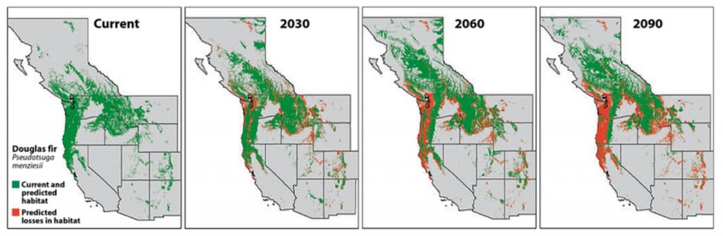
Shifting ecosystems can be interpreted by looking at the range of dominant tree species and biotic communities. One example in the Western US is the shifting of the Douglas Fir forest northward to higher latitudes and higher elevations.
All of the orange on the map in the below image are places where the current range will no longer be viable by the given time period 2030, 2060, and 2090. Unless there is some human assisted transition of those forest ecosystems, the agent of change will be fire. There are situations like this all over the planet.
If not planned for, shifting climate conditions and the subsequent shifts in ecosystems will create massive catastrophic fire potential. Assessing the overall survivability of an area in the coming decades is an important and realistic action to take. If an area appears to be high risk, then design based mitigation is the most productive course of action. The permaculture principle “creatively use and respond to change” is best utilized when change is anticipated in advance. Climate models and forecasts are giving us explanations of the present and glimpses of the future. This next section will look at ways that we can get ahead of wildfires with thoughtful planning.
Firestorm
There are certain magnitudes of fires that are so great that they create their own weather patterns, and as well may reach temperatures so high that everything that might possibly burn is ignited. Unlike a low intensity fire where soil nutrients can actually increase, in a high intensity fire soil nutrients are decreased as they volatilize with extreme temperatures[4]. In the situation that a very intense firestorm moves through a site, recovery can be more difficult due to the amount of material that will burn or melt, as well as detrimental effects on soils.
Site Mitigation Plan
The previous section was all about assessing the threat, with the goal of mapping the most likely direction that a wildfire will come from. At the individual site level, there are many strategies to employ to lessen the destructive force of a wildfire, and maybe even save the critical infrastructure of the site in case of a huge fire.
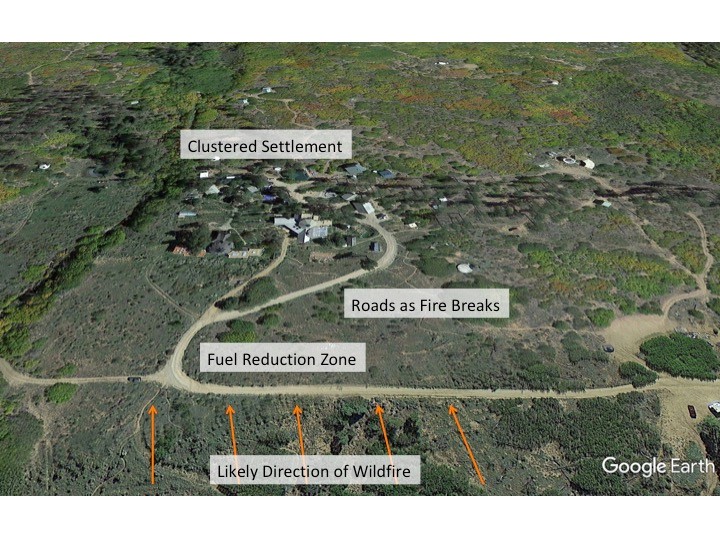
The first thing to plan for is a fire break between the likely direction of a fire and the important infrastructure of the site. Permaculture designed sites that use the concentric zone model have an advantage because the critical infrastructure is clustered in the inner zones that are the center of human activity. So infrastructure is less likely to be spread all throughout a site, but instead is clustered centrally for efficiency of movement and workflow. Of course each permaculture design site is unique, and will sit in its landscape in its own way, but there will be a tendency for clustering if the permaculture design protocol has been followed.
Fire breaks consist of any design element that will not carry fire through the landscape. Some examples are roads, irrigated gardens, crop fields, irrigated orchards, recreational lawns, concrete slabs, animal grazing areas, ponds, wetlands, greywater systems, and closed canopy hardwood forests comprised of fire resistant species.
The strategy is to nest the clustered critical infrastructure within layers of fire resistant elements to create a multi-layered fire break consisting of many elements to create a wide swath of “defensible space” that is unlikely to carry fire to the nested infrastructure. In permaculture the firebreak and protected area will consist of zones one, two and three.
We are not talking about a particular situation and scale here, but the most fire prone locations are going to be adjacent to unmanaged natural areas or industrial forest areas, and will either be rural, or located on the urban wildlands interface. Once we get deeper into cities, it is less likely for huge fires to sweep through, and the space that any one site controls for mitigation is small. So these suggestions apply primarily to rural areas and the urban fringe.
Beyond the fire break of zones one, two and three is the semi-managed zone four. This is where studying which forest types in a region carry fire and which don’t is important. In an interview with Erle Rahaman-Noronha of Wa Samaki Ecosystems, a permaculture farmer on the Caribbean island of Trinidad, I learned a lot about his design for fire mitigation during the dry season. Trinidad is located in the wet-dry tropics, so there is a period of vigorous growth of vegetation, including grasses, and then a long hot dry period where fire is a big risk.
For fire mitigation in his zone four, Erle established a closed canopy Teak plantation. When a fire approaches the Teak trees, it will lay down and burn cool in the understory, leaving the trees overhead to survive and stopping the fast and hot spread of the fire. As a rule of fire mitigation in existing forests, fire ladders are eliminated through pruning that can carry fire from the ground into tree canopies. The idea of closed canopy hardwood forest systems and their ability to “lay down’ fire is a concept echoed by permaculture planner Tom Ward. Planned and managed forest systems can function as vegetated fire breaks[5].
Erle also uses donkeys to keep dry grasses down, resulting in “mowed” fire breaks. Using animal grazing and patterning their rotation on a site so it keeps down vegetation in the fire sector is a great integration strategy that is applicable for different climate zones. Where some animals graze grasses like donkeys and sheep, other animals eat woody material, like goats. A herd of goats rotated intentionally through areas where fuels have built up can be very effective in maintaining fire breaks and transmuting woody fuel into milk and meat.
Erle is able to irrigate areas with overhead sprinklers when fire is approaching, and will soak his main cash crop of cut flowers in the event of a fire to use both as a fire break for other critical infrastructure, and to save the crop which is the farm’s main economic income. Having the existing irrigation system also doubling as a fire-break soakage system is a great example of stacking functions[6].
This connects to the whole main frame design process of a site in the way that the water use of sprinklers as an irrigation system will affect the water use and need to be planned for in the overall water-use equation. Drip irrigation certainly uses less water, but will not accentuate the firebreak aspect of a green and growing field of annual crops like sprinklers will at the point of crisis. This could bring up interesting choices for some sites: Can you afford to plan for greater water use in a field because it’s also a fire break? Does that work with the total water budget for the site? Fire is a yearly occurrence at Erle’s Wa Samaki Farm in Trinidad, so the design is built around fire, where there are also numerous storages of water throughout the landscape to serve as reservoirs and fire breaks.
Fire is especially risky in permaculture systems where planting trees, increased biomass, and increased vegetative coverage are goals. Integration of water storage in the landscape becomes an important balancing point to the increase in biomass and fuel load. Also, the planting pattern of agroforestry and perennial systems is important in its consideration of how fire will move through that landscape.
Water Storage
There are a number of important considerations around planning water storage structures built specifically for firefighting, fire breaks, and fire suppression. Planning water storage structures is part of a site planning process that puts the design of water flow as the first major design element on which other design elements are layered, like access, perennial plantings, structures, and fencing.
If a water storage pond is primarily to be used for fire suppression, then it needs to be designed to be full during the dry season. Unless the pond is being replenished by a perennial source throughout the dry season, it cannot also be an irrigation pond that is in use or it will dry up. A fire suppression pond is a great pond for recreation, as it maintains its water level throughout the hottest and driest time of the year.
Other considerations for pond design includes the ability for the water to be released by gravity and wet down areas to prevent the spread of fire or spot fires starting from flying embers. Often times the power grid goes down during a large scale regional wildfire as transmission lines are damaged. If topography allows, it’s best to have water storage up above the fire sector with a manual valve to flood areas within the fire break. A gravity fed sprinkler irrigation system can also be used to wet down areas to avoid ignition and spot fires.
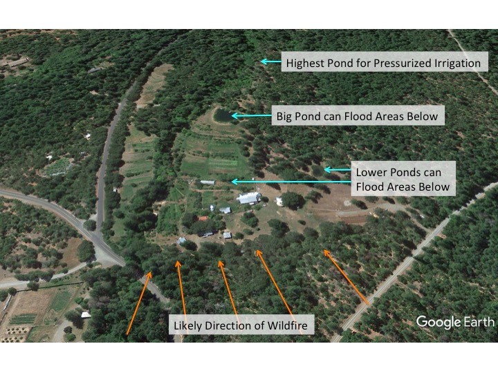
In this map, we can see the elevational relationship between the main water storage pond, the homestead, and the likely fire sector. Water is pressurized by gravity and can be released to flood lower areas in case of fire.
Access to water storages by fire fighters is another important design consideration. There are two pieces to this. One is access to ponds by fire fighting helicopters. In the United States, helicopters with buckets attached are important fire fighting tools in hard to reach areas. If there is a fire close by and helicopters have easy access to a pond, then their trips back and forth to water are that much shorter and they are that much more likely to get the fire out.
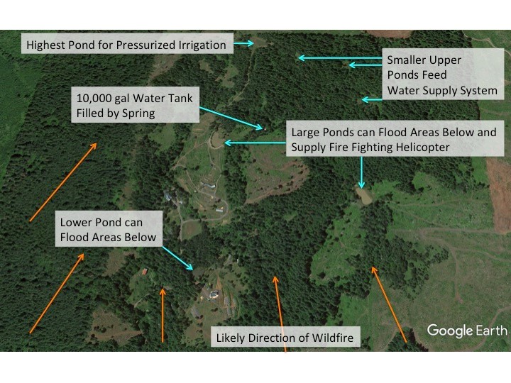
This is the case at Cougar Mountain Sanctuary, a permaculture site in the Cascade foothills in Oregon, USA. Their numerous ponds were placed with firefighting helicopter access in mind.
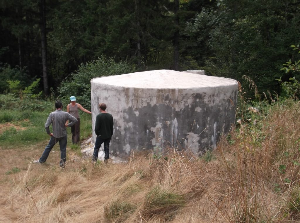
There is also access for fire trucks to account for. This translates to road and turn-around access to critical areas of the site in general, as well as specifically having access to water tanks that have a hook-up that fire hoses can tap into. At the Aprovecho Appropriate Technology Center in Cottage Grove, Oregon they built a 10,000 gallon ferro-cement reservoir that fills from rainwater off of a roof and remains full throughout the growing season. Although the garden is irrigated from this tank, it is continually kept full to a certain level from a well during irrigation season. When the level drops, water is pumped in and the level is replenished, and then it’s allowed to empty at the end of the fire season to collect roof runoff. Importantly, it is fitted with hardware that is sized so a firetruck can pump out of it in the event of a fire.
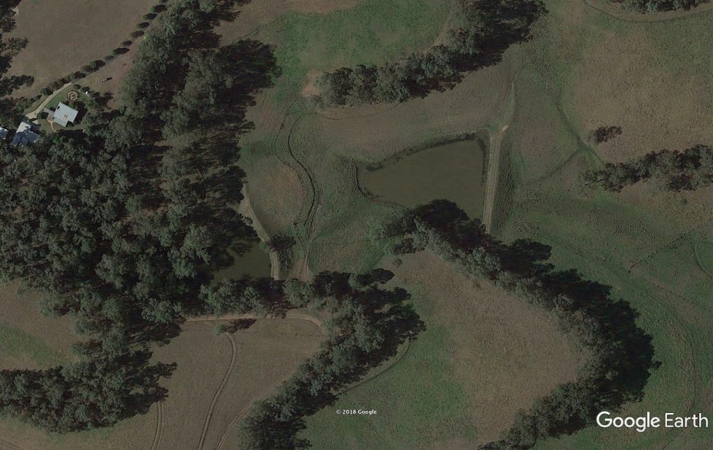
A water tank has no evaporation, but an open source of water like a reservoir will have water evaporate. So if a pond will not be replenished during the fire season and the goal is to maintain water in that pond in case of fire, then evaporation will need to be minimised. Evaporation is accelerated by both wind and sunlight, so sheltering the pond is essential to keeping it as full as possible. Different climate zones have different strategies for reducing evaporation of open water storages, and this text will not go into detail about each one. The image below shows an example of windbreaks integrated with ponds from P.A.Yeomans property “Yobarnie” in Australia:
Structures
The design of structures to for resistance to flames, extreme heat and flying embers is a topic that could fill an entire book, and the totality of the subject is beyond the scope of this text. However, we will briefly cover the main aspects to consider.
In a major region-wide wildfire, the heat produced can be intense, and even if the flames do not destroy a structure, structures can be damaged simply due to their proximity to a fire. This is where a macro view of the topography, fuel and weather patterns are important to get an honest assessment of the potential in a region and for the design and placement of structures.
The external materials used on a structure are very important because these are the materials that will catch fire or not. The roofing material is obviously very important, especially in the presence of flying embers, which as mentioned before can go very far in a massive fire. Embers can actually blow into a house through vents and gaps, igniting a structure that burns from the inside out during a wildfire. Eaves will trap burning embers with updrafts of wind occurring in front of the fire, and this is an easy way for a roof to catch on fire, as often times a metal roof will still have exposed wooden eaves on the underside. Many people in very fire prone regions will outfit sprinklers to their roofs to wet them down, supplied ideally by a gravity pressurized source.
I parked on a ridge in 2002 overlooking the Indian Fire as it spread through the southern edge of Prescott, Arizona, a landscape that is a mosaic of Ponderosa Pine forest and High Desert Chaparral, watching a man standing on his roof hosing it down continually until he was forced to evacuate. That landscape is the quintessential urban-wildlands interface located in a fire sector with very flammable fuels, seasonally high winds, and steep slopes leading right from vast unmanaged forest areas directly into the city.
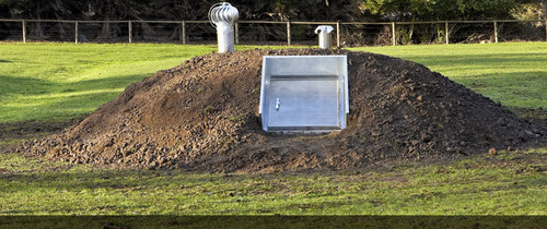
A house located in that type of high risk landscape should be fireproof. This may mean that the structure is partly underground, with a living roof, and no exposed flammable materials. Even with the house burning, there should at least be a bunker to retreat to for life saving protection from flames and extreme heat. A quick search on the internet for “wildfire bunker” will yield a number of prefabricated models. In Australia the term is “bushfire shelter”, and there’s seems to be an established market in that fire-prone continent. Maybe this spends most of its time as a root cellar, but is also designed as a refuge with proper ventilation, stocked with water and a temporary toilet for when it’s needed.
Other recommendations have to do with outbuildings and wood storage, and making sure that big loads of flammable materials are well away from critical infrastructure. Remember the pattern of nesting critical infrastructure within the band of fire breaks. Flying embers may come into the protected area and should not be able to fall onto a wood pile and start a big fire within the protected zone. Things like wood storage and propane tanks should be located within ember proof structures. The types of critical infrastructure that should be nested within the inner zone is the well, water tanks or other water source, energy generation center, vehicles, animals, other equipment, food and material storages, propane and other gas or liquid fuel storage, and economically important crop areas.
Extreme Event Survival
There are some elements to include on a site in order to survive a wildfire at the point of crisis. Above, the fire bunker was already mentioned, and its potential multiple uses as a root cellar or something else. Another extremely important consideration during the site design phase is evacuation.
Designing multiple ingress and egress points on the property can be a life saving endeavor. Especially in areas where fire can come from multiple directions, having evacuation routes going in different directions are important. This also may be a factor in choosing a site in the first place. When considering a property in a location in a very fire prone area, it is essential to think through a possible wildfire at the outset, and whether or not there is the possibility of being trapped in a dangerous situation, like at the end of a thickly vegetated box canyon with only one way in or out.
On the same note as evacuation is the planning of a meeting place in the event of evacuation. It’s important to recall that cellular phone service and the power grid can be taken down in a large regional wildfire, so there may be no means of communication with loved ones. Having a predetermined safe meeting place is prudent planning. It is standard practice in schools to have fire drills. During fire drills, everyone goes out to an open area away from buildings that appears like it would be safe from fire. This is the same concept, but on a larger scale.
Another important thing to consider is being present on site during fire season to be able to respond to a situation immediately. That’s what Erle in Trinidad does, where there is always someone on site during fire season, 24 hours per day, to be able to immediately respond to a situation and fight a fire. This could be very important if evacuation is needed and there are animals on site, or if a firebreak can be accentuated by opening up a reservoir and flooding an area.
Regional Mitigation
The scale that needs attention when talking about regional mitigation of wildfires is the bioregion. When we’re talking about changing species distribution at the scale of entire ecosystems marching towards the poles, it really needs a macro view to have any meaningful response.
In interviews with permaculture elder and forester Tom Ward, there were a number of recommendations from a permaculture design perspective for wider ecosystem scaled responses to the issue of changing forest types.
To start with, we will return to the concept of slope aspect and recall that in the temperate climate, the fire sector is very dependent on the aspect. Hotter slopes with a sun-facing aspect are south and west in the northern hemisphere, and north and west in the southern hemisphere. Management of different slope aspects should be different, and this can be a patterned management approach at a regional level.
Cooler slopes should be developed as refugia for retreating species, and their coolness and wetness should be enhanced to remain as a viable microclimate for retreating species as the climate warms. Warmer solar exposed slopes that are much more fire prone should be managed for fuel reduction by managed grazing and controlled burning.
The conventional and commercial response to the need for fuel reduction ahead of ecosystem changes would be the logging of endangered slopes. But access to these areas with logging roads and the compaction of heavy equipment will damage the watershed and reduce the capacity of the area to hold water, further accelerating the drying of the land. Logging also leaves a lot of slash on the ground which all becomes dry dead fuel for more fires.
Selective downing of standing trees to thin stands could be really effective if they were left on the ground on contour, with log to soil contact, so they acted as water slowing swales, where snow, water runoff, and detritus would be slowed down and help to build water and soil in the watershed. This would both reduce fuel, as well as build the water holding capacity of the slopes for healthier vegetation and greater resistance to fire with less dead standing fuel.
The above suggestions are an overall strategic perspective with an example of a particular technique, but the techniques will differ from region to region. The main point is that with changing climate and changing species distribution, not all solar aspects and microclimates will have the same effects, and the design for a new ecosystem should account for these differences.
Recovery
Living in the Western United States, I have had a lot of opportunity to watch burned areas recover over time in multiple different forest types and ecosystems. One thing I’ve witnessed is that there are species who appear to thrive on the renewal caused by fire, and will quickly shoot up to take advantage of the access to sunlight and the nutrients contained in new layers of ash. The pioneer species and fire-dependent species will differ from place to place, but they are present in every natural ecosystem that has regular fires as part of its life cycle.
Immediately after a fire there is the risk of erosion and landslides before any vegetation recovers and heavy rains occur. This is common when the fire season is followed by the rainy season; there is no time for recovery. Landslides can be just as catastrophic as wildfires, so the risk must be assessed and preemptive evacuations made if necessary.
Soil stabilization work must begin right away. It may be that the gardener quickly throws down seed balls or seed bombs, where seeds of desired pioneer species are mixed into a clay and manure ball that protects the seeds until rain melts the ball and germinates the seed. There are many other erosion control structures that are too numerous to mention in this book, that would assist soil stabilization in different types of ecosystems and climate types. But overall the scale is the biggest concern. Major wildfires cover a lot of ground in a short time frame, and can result in an overwhelming area of exposed soil to be created all at once. So it is necessary to have a realistic perspective on how much stabilization work can be done between the time of a fire and that of heavy rains.
What will help is to have a vision of the desired successional model for a recovered agroecosystem. In permaculture it is said that the problem is the solution. One thing that a fire can provide is a total reset for an ecosystem and a point of intervention in the system where a permaculture designer can guide succession towards a productive landscape.
This happened in Northern New Mexico in 1996 to a community called the Lama Foundation, and their recovery from a devastating fire is documented on their website, where their core central node survived the fire, and the rebuilding and new landscape centered at that nucleus, and spread outward to the entire larger site:
“On May 5, 1996, a massive forest fire turned the once highly forested area into a relative empty expanse. The fire, which consumed about 7,500 acres of national forest, nearly wiped out everything at Lama Foundation. However, the Dome Complex and the kitchen, along with the, as yet incomplete, new kitchen and community center, survived. Twenty-two other buildings were entirely destroyed. The Intensive Studies Center (ISC) was burned to rubble though much of the foundation and the original adobe walls remained intact. Work immediately began to rebuild Lama Foundation, and enormous outpourings of love, effort, and funds poured in….
Throughout the late 90’s and the first decade of the new millennium, Lama Foundation began building with a new vision, adding permaculture to the spiritual and community focus that were always present. Massive efforts were undertaken to protect the unstable soil from eroding and to provide clean drinking water. New buildings were constructed with fallen timbers, straw bales, cob walls, passive and active solar heat, and other natural building techniques. New gardens were developed, and the whole mountain buzzed with activity.”[7]
- Leavell, Daniel et al. “Fire Science Core Curriculum”. Oregon State University Extension Service. Aug. 2017. Oregon State University. Web. Jan.2018 https://catalog.extension.oregonstate.edu/sites/catalog/files/project/pdf/em9172.pdf ↵
- “Fire Season Climatology”. Fire Behavior Field Reference Guide. Dec. 2017. National Wildfire Coordinating Group. Web. Jan. 2018 http://www.fbfrg.org/weather/fire-season-climatology ↵
- “Fire Season Climatology”. Fire Behavior Field Reference Guide. Dec. 2017. National Wildfire Coordinating Group. Web. Jan. 2018 http://www.fbfrg.org/weather/fire-season-climatology ↵
- “Fire Effects on Soil Nutrients”. Northern Arizona University. Web. Jan.2018 http://www2.nau.edu/~gaud/bio300w/frsl.htm ↵
- Millison, Andrew S. “Tom Ward Aka Hazel: The Truth About Wildfire.” Soundcloud, Earth Repair Radio, 18 Oct. 2017, soundcloud.com/user-193856180/episode-012-tom-ward-aka-hazel-the-truth-about-wildfire ↵
- Millison, Andrew S. “Erle Rahaman-Noronha: Superstorm Resilience.” Soundcloud, Earth Repair Radio, 4 Feb. 2018, https://soundcloud.com/user-193856180/episode-014-erle-rahaman-noronha-superstorm-resilience ↵
- “History of Lama Foundation”. Lama Foundation. Web. https://www.lamafoundation.org/about-lama-foundation/history-of-lama-foundation/ ↵
