10 Tropical Cyclone Effects
Threat Summary
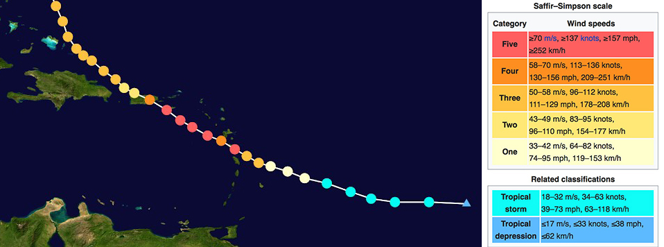
Hurricanes, cyclones and typhoons are all words that officially translate to the same thing, a tropical cyclone. Which term is used depends what part of the world the storm is in. A storm is named and becomes a tropical storm at 39 mph or 63 kph. It enters the category of tropical cyclone at 74 mph or 119 kph. There are different categories, and it enters the strongest category 5 at 155 mph or 249 kph. In Australia there is a different categorization. For this chapter we will use the term tropical cyclone to describe the event[1].
According to the US government’s National Oceanic and Atmospheric Administration (NOAA), they have five major conclusions about tropical cyclones that they are stating which I have paraphrased below:
- It is inconclusive as to whether or not greenhouse gas emissions have yet had a detectable impact on global tropical cyclone activity. They may have, but there’s not enough data to substantiate this.
- It’s likely that anthropogenic warming will raise the wind intensity of tropical cyclones by 2-11% by the end of the 21st century. When that is translated to the actual destructive potential per storm, the percentage becomes higher as particular wind speed thresholds are broken.
- There are “better than even” odds that tropical cyclone wind intensity will be much higher than the 2-11% increase. This does not increase the number of storms, but their intensity. This is less likely to apply to the Atlantic Basin.
- Anthropogenic warming is causing greater atmospheric moisture content and this will increase the amount of rainfall from tropical cyclones 10-15% within 100 km or 62 miles from the eye of the storm. There is “medium confidence” that this is already happening.
- Sea level rise will cause higher storm surges for tropical cyclones when all else is assumed equal.[2]
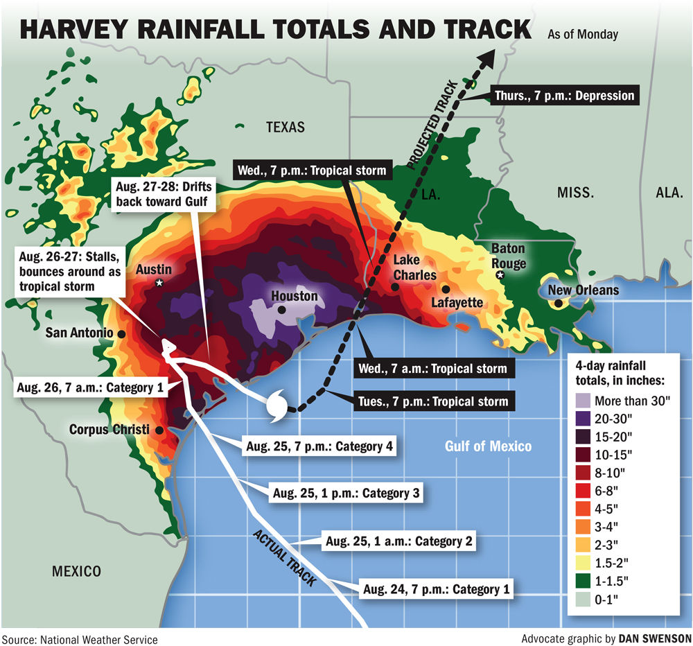
The magnitude of this new reality was evident in the summer of 2017, when the United States National Weather Service had to add a new color to their maps to express how much rain fell in the Houston, Texas area in the 4 days that the storm lingered there.
Site Assessment
When assessing the actual danger to a site from the permaculture design perspective with the goal of mitigating that threat, there are several things to look at in relation to wind. The following section in this book will cover sea level rise and storm surge, so those impacts will be examined separately from wind.
The first thing to do is research historic events that have hit areas with a similar geography, like island, delta, barrier island, major coastal city, steep hillside, flood plain, and the many other geographic positions around. What were the maximum wind speeds? What was the total rainfall accumulation? What direction did the winds come from? What was the greatest source of damage? Was there flooding? What were the barriers to recovery? What species survived? Although it was stated above by NOAA that wind intensity and rainfall amounts are forecasted to go up, and may have already, a look into history will reveal what we absolutely do know is possible.
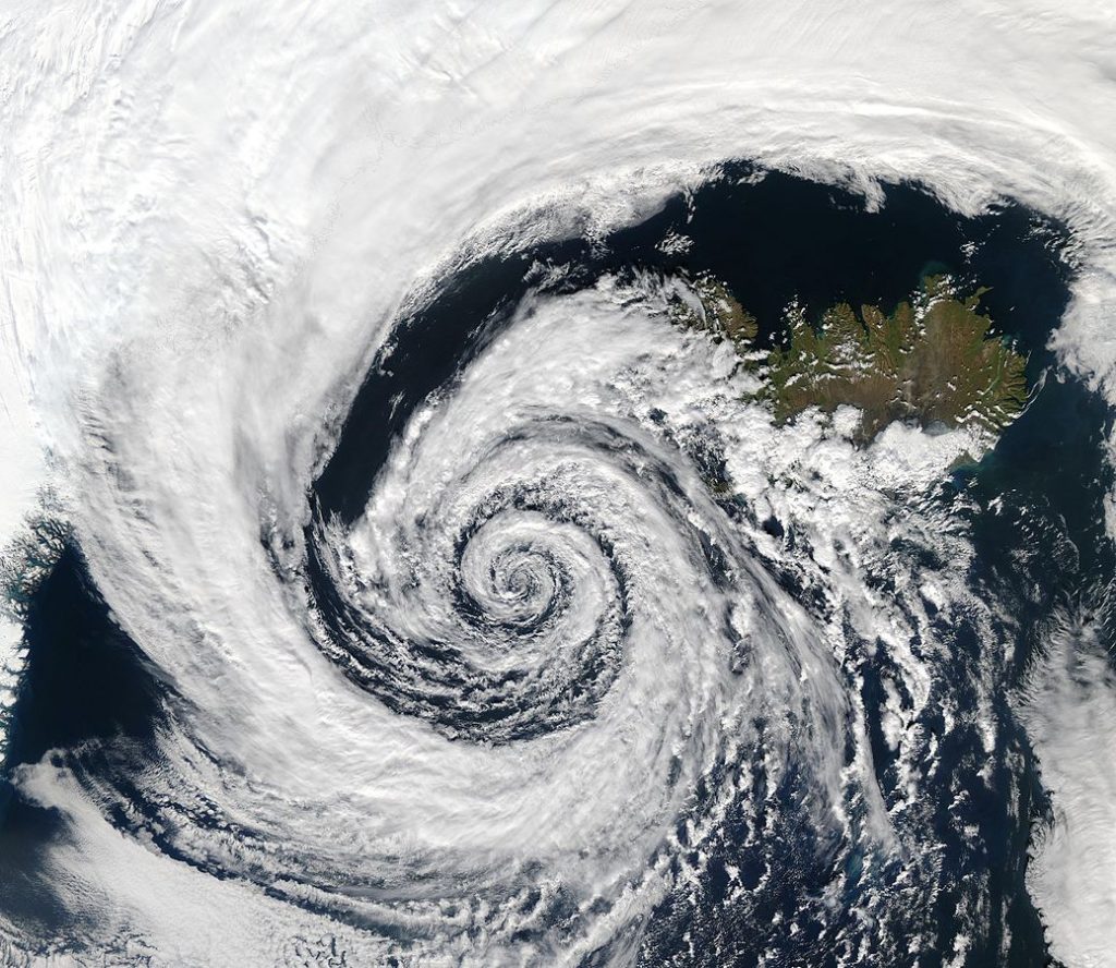
Mapping wind direction and creating a tropical cyclone ‘sector’ like we like to do in a permaculture site analysis is tricky, because cyclones swirl by their nature. So depending on how a site is oriented within that swirl, intense winds can literally come from any direction. This image of an extratropical cyclone off of the coast of Iceland really illustrates the fact that winds in a cyclonic system can come from every side depending on where a site is in relation to the cyclone pattern:
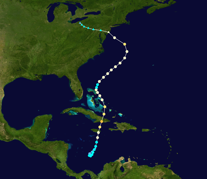
The same goes for where and how these storms make landfall. They can take erratic twists and turns at the last moments and follow very surprising paths, as we saw with Hurricane Sandy that struck New York City in 2012.
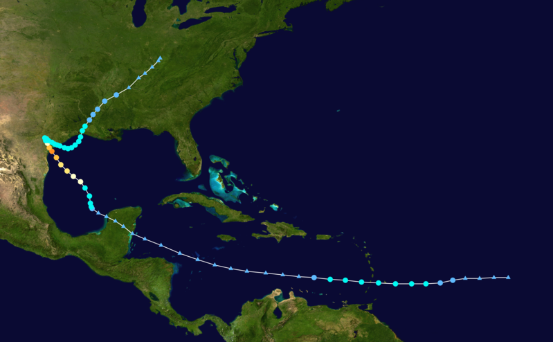
We see another example of an erratic pathway in Hurricane Harvey from 2017, whose twists and turns sheds light onto why it was used as an example above of an unprecedented amount of rainfall accumulation:
So the point is that you won’t be able to create a cyclone sector on a sector compass diagram. That sector comes from everywhere. But there are other sectors related to tropical cyclones that can be mapped. Below are four important elements to map out:
1) Distance to coast
How far from the coast is a site located? Winds dissipate as the storm moves inland
2) Elevation above sea level
This is important for analysis in terms of storm fueled sea level rise.
3) Watershed
What is the potential for flash flooding in a watershed, based on the size of the watershed? What is the health of the watershed and its ability to absorb water, or on the flip side, the amount of non-absorptive water shedding surfaces? Where a site sits within the watershed? Low areas receive inevitable flash flooding that occurs with heavy amounts of rainfall all at once.
4) Geology
Where does the site sit in relation to potential landslides due to extreme rainfall, and how stable is the geology to handle the load? Is there unstable and denuded land at risk of slippage?
Some of the specific damage that comes from tropical cyclone winds is defoliation. During the Atlantic hurricane season of 2017, there were multiple direct hits with category 5 storms on a number of locations, and the impacts were tremendous. Hurricane Maria landed a direct hit on the Caribbean Island of Puerto Rico, and completely denuded the island’s prized El Yunque National Forest[3].
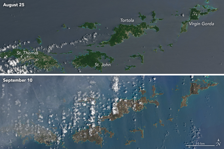
After Hurricane Irma went through the Caribbean in September of 2017, NASA released satellite imagery revealed before and after images of the islands of Tortola, St. Johns, St. Thomas, Barbuda, Antigua, and Virgin Gorda, showing them turning from green to brown overnight.
Just like a major wildfire, a tropical cyclone represents an ecological disturbance at the level of an ecosystem reset. This doesn’t just go for the natural environment, but can also destroy buildings, and even flood whole towns and cities. One major difference between the impacts of of a tropical cyclone versus a wildfire is that in a wildfire, the impacted area has a major fuel reduction event, and will not have the same fuel load and potential for many years. But a tropical cyclone can strike the same location more than once in the same season, and certainly the next year or any year after that. So planning really needs to be for repeated events to have long term resilience.
Extreme event survival
There are three aspects to surviving a tropical cyclone that are discussed in this section. They are preparation before the event, survival during the event, and survival during the aftermath of the event. There are many lessons to be learned from history on this, as there have been so many massive tropical cyclones during recent times to study.
Evacuation
Evacuation can be one of the best ways to survive a massive tropical cyclone that is approaching. With modern satellite technology, there is forewarning of approaching tropical cyclones, and forecasts of their potential routes. However the nature of the patterns of movement and intensification of the storms is chaotic. The fact that storms are named is indicative of the fact that they have their own “personality”, and can be erratic and unpredictable, at least for now. This statement comes out of recent observations of hurricanes from the summer of 2017.
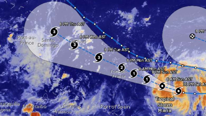
The below image tracks the Hurricane Maria and its intensification as it approaches the Islands of Dominica and Puerto Rico. You can see that it goes from being a tropical depression (blue triangle) to tropical storm (blue circle) and then from a category 1 hurricane (beige circle) to a category 5 (red circle) in an extremely short distance. This is called rapid intensification and the people on the islands of Dominica and Puerto Rico were caught off guard without a lot of time to prepare for that level of wind intensity.
The early forecasts had the speed of intensification much lower and most looked a lot more like this:
With rapid and unforecasted intensification, evacuation may not be an option. This is especially relevant on an island, where air evacuation is the only way to get off of an island quickly, and is only an option for a limited number of people who have the resources for an impromptu flight.
When a superstorm is approaching land, there is much more potential for evacuation overland. Hurricane Irma approached Florida as a category 5 storm 2 weeks before Maria struck in the summer of 2017. This prompted the largest evacuation in Florida’s history of 6.5 million people.
Evacuation also has its hazards, and the 2005 evacuation of 2.5-3.7 million people from the Houston, Texas area as category 5 Hurricane Rita approached is remembered for standstill traffic in 100 degree F (37 degree C) heat, where some people were out on the road for up to 36 hours. The hurricane weakened and changed course, but if it had struck at its full intensity, those who evacuated and were stuck outside could have been at the greatest risk.
From the permaculture perspective, mass evacuation is not the best option. Preparation is. Because mass evacuation depends on a level of industrialization where the highway system, power grid, and fuel distribution systems are able to serve millions of people in an energy intensive and possibly hazardous relocation. Mass evacuation is certainly an option for some nations and some citizens, but is less of an option for those without access to resources.
One glaring exception to the inequity and chaos of mass evacuations is the Island of Cuba. As a socialist republic, the central government controls the lion’s share of resources and infrastructure. Cuba sits in the Caribbean Sea in an area that is very prone to tropical cyclones, and has an extremely organized system of mass evacuation into government shelters. During Hurricane Ike in 2008, the Island successfully evacuated a quarter of their entire population, 2.6 million people, without major incident. That level of control and organization is much more difficult to accomplish in capitalist economies, for better or for worse[4].
Establishment of regional shelters and localized evacuation is a much better option from the permaculture perspective then massive evacuation out of a region entirely. It is important for people to assess their particular risk when there is not a tropical cyclone approaching. Site analysis is the first key measure to take, assessing the stability and resilience of structures, elevation above sea level, positioning in relation to a floodplain, stability of nearby slopes, and overall integrity of the watershed. Once a tropical cyclone based site analysis has taken place, then the need to evacuate in the event of a storm may be very clear, and contingency plans can be made well before the event occurs. The information about the potential risk to an area can also be shared with friends and neighbors, so the community as a whole is psychologically and physically prepared for the event.
During the storm
When riding out the storm, survival depends on the site design and preparation discussed in more detail in the “Site Mitigation Plan” section. The quality of housing and presence of a shelter are essential. Flood, salt, and wind resistant plant species, and a knowledge of local edible plants will all aid in survival. Housing for the protection of animals is also essential to keeping an agricultural system intact, as well as stores of food, medicine, and other essentials. Alternative and decentralized water, energy, and waste treatment systems are also described in greater detail below in the “Site Mitigation Plan” section.
Storage methods
In Cuba in 2013 at the International Permaculture Conference, there were multiple talks by Cuban permaculture practitioners discussing their tropical cyclone resilience strategies, some of which are mentioned in the text. One important point they brought up was about storage and planning storage of essential items to withstand wind and water damage. The example given was the storage of seeds. People who stored their seeds in glass jars on the shelf risked the shelf falling over, the jars smashing, and the loss of the seeds then to water damage. People who stored their seeds in plastic containers did not suffer the loss of their seeds when the building containing them was compromised. Those small details can mean a lot during the recovery and replanting period.
In the event of the situation that was described in Myanmar with Cyclone Nargis, it’s hard to say what the population of the entire Irrawaddy Delta should have done when storm surge brought water 25 miles (40 km) inland and 150,000 people died. In an ideal world, there would be local shelters that were raised up above projected storm surge levels and were resistant to cyclone force winds. These shelters would be stocked with supplies and would be plentiful enough to house the population during a storm and dispersed enough that a population on foot could reach them. The shelters could double as community centers, schools, food storage and distribution centers, or serve some other regular infrastructure purpose. In the US, many schools end up serving as shelters during disasters because of their size, construction, location, and distribution. In an impoverished country like Myanmar that hosts the world’s longest running civil war[5], an infrastructure building task of that magnitude could prove challenging.
Site mitigation plan
Designing a site to be resilient to tropical cyclones has a few different parts to the whole picture, and on the physical level those are structures, energy, grading and drainage, forest and cropping systems. When talking about the destruction from storms, most people focus on structures, so that’s where this section will begin.
Structures
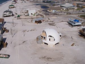
In a major wind event, the interface between walls and roof is a point of failure, and roofs will be peeled back and blown off of a structure in the worst case scenario. So one major architectural strategy is to either reinforce the interface between the walls and roof and strengthen the roof’s connection with the ground, or avoid having a roof that is separate from the structure at all. Domed structures do not catch the wind like a more conventional roof with eaves. This is why domes are so resilient to strong winds, as we see in these images of Earthship cyclone shelters on the island of Vanuatu in the Pacific Ocean

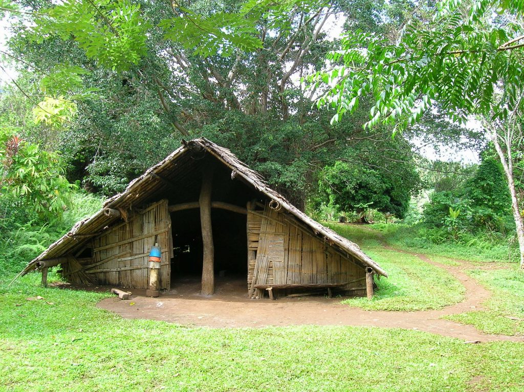
There also a lot to learn from the design of the traditional Native American Navajo Hogan located on the Colorado Plateau in the USA, where very strong winds blow.
Shelters without sharp angles to catch the wind will in general be more resistant. In the images above, we can see there is no point where the roof juts out. It is contiguous with the ground. Another strategy is to have a roof extend all the way to the ground, and be tied to the ground for greater support. This is a strategy used in the tropical cyclone prone island of Cuba. On permaculture sites, with a tight central cluster of buildings, they will tie all of the buildings and other associated structures for animals and storage and processing together so they form an interconnected building web, which is more strongly rooted than single isolated individual buildings.
Retractable Infrastructure
Structures and systems that are built to be taken down without a lot of notice and stored safely during storms is another effective resilience strategy. This could include solar energy and solar hot water systems, wind turbines, greenhouses and hoop houses, trellising, portable fencing, and portable animal structures like chicken tractors.
In this day and age of satellite technology, there is advanced warning of approaching storms. Even though storms can take surprising turns, there are still warning systems in place.
Decentralized Energy, Water, and Waste Systems
Power grid failure is a reality in the aftermath of major storm events, and power can take days or weeks or months to be restored. Three months after Hurricane Maria devastated the Caribbean Island of Puerto Rico, power was only back on for half of the population[6]. Decentralized power systems like solar, wind, micro hydro, and biomass energy generation can turn a long term power grid failure into uninterrrupted or briefly interrupted power supply.
Water sources and supply systems have the same parameters. If water is provided by a central grid that involves the power grid for treatment and distribution, then that can fail long term as well. Permaculture urges to have multiple sources of essential elements. So backup water supply could be rainwater harvesting tanks, a well to access stored groundwater, development of a spring, or home-scale treatment of wastewater. The backup water system could be integrated with an alternative energy system.
Many flush toilets are also connected ultimately to the power grid for pumping and treating water at a municipal scale. Composting toilets, constructed wetland treatment, greywater systems, and a number of other localized waste treatment systems are all encouraged with permaculture design. The number and types of systems and their appropriateness to particular situations is too big of a topic to cover in detail in this book. There are numerous resources to study for more information.
Forests and cropping systems
There are a couple different aspects to planting systems that will be discussed. One aspect is the stability of the landscape from heavy inundation by major rainfall. The other aspect is having food to eat in the aftermath of a major tropical cyclone.
Watershed stability
Permaculture is known for its design of earthworks, which are excavation and sculpting of soils in connection with water management. Earthworks are often done as part of water harvesting and soil stabilization systems. It is always advised to size the capacity and overflow of water management earthworks to handle historic level flood events. But in some instances, that may not be practical, given the magnitude of rainfall that is being dropped by some of these storms. Designing earthworks systems to handle the 40 inches or 1000 mm of rainfall that fell in 48 hours during the US Gulf Coasts’ Hurricane Harvey in 2017[7] may just not be feasible for some sites given the amount of space and existing infrastructure, or size and condition of the watershed upstream of the site.
When it comes to the watershed during a massive rainfall event, big risks are soil erosion and landslides. In the event that earthworks are overwhelmed or fail, tree cover on steep slopes and tree belts interspersed throughout the landscape are essential. The more tree cover, with deep intertwined roots, the more stable soils and slopes will be, and will provide security in the event that other water management structures are overwhelmed.
Another aspect to this strategy falls within the general permaculture pattern of breaking the landscape up into smaller field components. This is accomplished with hedgerows and agroforestry belts that are integrated into open field areas. So the end result is that there are fewer large open expanses, where forces like wind and water can concentrate. The landscape is a tighter mosaic of field and hedgerow, where belts of trees and shrubs with deep perennial roots are more dispersed throughout the land, keeping soils stable.
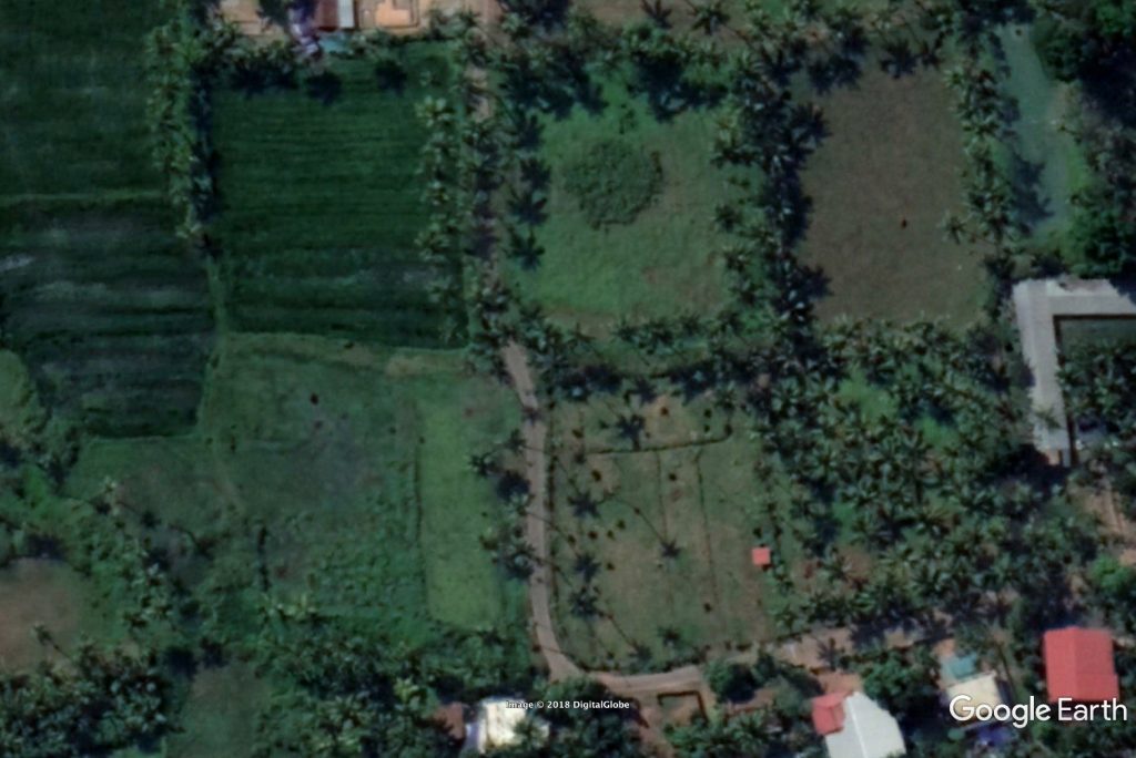
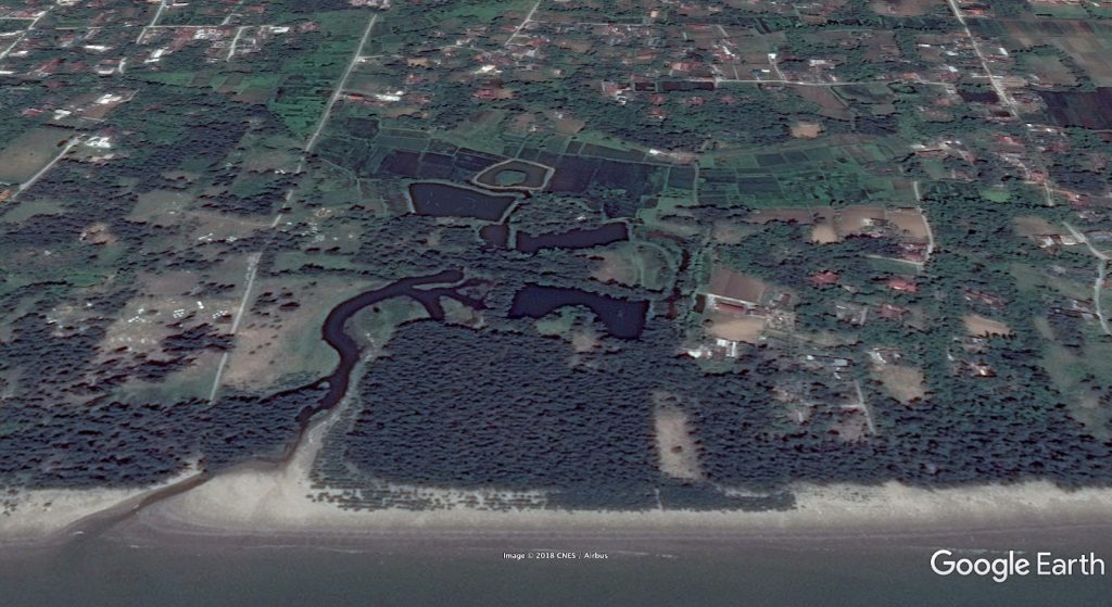
This Google Earth image from India’s cyclone prone southern state of Kerala shows small fields bordered by trees.
Species selection
As far as species selection, there are a number of species that are known in the tropics for their soil stabilization qualities. These are Vetiver Grass (Chrysopogon zizanioides), Napier Grass (Pennisetum purpureum), and different species of bamboo, to name a few examples. It’s necessary to avoid introducing a potentially undesirable rampant species, so this needs to be considered with any tough species brought into an area.
It is also necessary to consider the potential fire danger of planting lots of grasses and bamboos, as many areas located in the wet-dry tropics that are prone to tropical cyclones are also prone to wildfires during the dry season. The placement of any fire prone species needs to be considered with proximity to major infrastructure, and it requires an advanced level of design to plan for both tropical cyclone and fire resilience in the same landscape.
Selecting tree species that can withstand tropical cyclone force winds and have a measure of salt tolerance is wise. A quick internet search reveals resources available for tree and shrub selection from the University of Florida and James Cook University in Australia for sources in English.
Resilient perennials
In a previous section, the risk of complete defoliation from strong winds was explained and demonstrated with satellite images. The planting plan needs to account for this possibility. In permaculture, zones one and two are considered the inner zones that are clustered around the house or central area of human activity. This is where the diverse home garden and orchard, compost, and small animals are often located.
Annual and perennial root crops are potentially ready for immediate foraging after a tropical cyclone, even if the above ground portion of the plant is defoliated. So having a diversity of root crops in the ground provides some level of food security. Additionally, wild leafy greens that are perennial may come back rapidly after a big disturbance. The typical permaculture homestead model of a diverse polyculture garden immediately around the house full of perennial edible and medicinal plants is a great pattern for providing forage after the storm, and plant selections can be made to maximise disturbance resistant species.
Regional Scale Mitigation
At the regional level, there are some major strategies that could go a long way to mitigate the impacts of tropical cyclones. Actions on this scale predominantly need to be undertaken at the level of zoning ordinances and planning departments, and have to do with appropriate land use related to slope stability, flooding, and coastal stability.
The first thing is for a watershed perspective to be adopted by municipalities and communities so assessment and planning can happen on the scale that it needs to. In an interview with Erle Rahaman-Noronha of Trinidad, it was pointed out that the watersheds of the Caribbean Islands are small, which makes flash flooding more of a threat than widespread flooding at the bottom of large watersheds. This is not the case for all tropical cyclone prone regions by any means, but it is typical of the geography of Islands.
Tropical cyclone Nargis that hit Myanmar in 2008 is considered the worst natural disaster to strike that country in recorded history. There was catastrophic flooding caused by a storm surge that sent water 25 miles (40 km) inland through the densely populated Irrawaddy Delta, killing nearly 150,000 people. There was also large amounts of rain that fell in the large watershed, so rainfall flowed down into the same delta that the storm surge flowed up into. This was in addition to category 4 winds of 130 mph (215 kph).
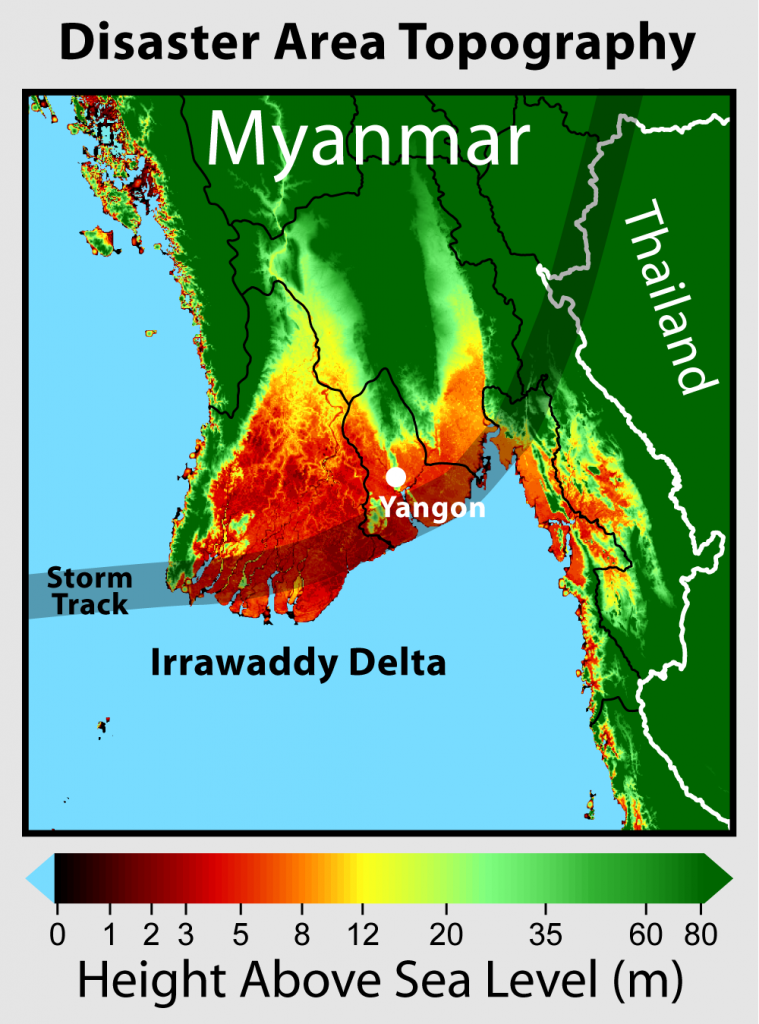
So the scale of potential damage and mitigation has a lot to do with the scale of the watershed and the amount of low lying area that is at risk of widespread flooding and the amount of slopes that are at risk of landslides.
Mitigating the risks in uplands are the same strategies that we see for slopes and watersheds in general in permaculture design. Some of the typical strategies employed are listed below and some are the same strategies employed by government soil conservation services:
- Planting areas steeper than 30% slopes in permanent forest cover
- Interspersing trees and hedgerows throughout gentler slopes
- Breaking up large areas of open lands into smaller segments divided by perennial hedgerows
- Covering soil for greater water absorption and percolation
- Aligning roads and crop rows so water is maintained and soaked into the landscape instead of shed into drainage systems
The lowlands will benefit from water moving down more slowly from high ground, but coastlines are a different story. In a natural system, coastal vegetation can reduce storm surge. This could be coastal forests like Mangrove, coastal marshes and vegetated dunes. Depending on the type of storm, it’s wind speed, duration, and intensity, coastal vegetation may or may not actually reduce the overall storm surge. It’s a complicated formula. But it certainly can help in many cases, and will undoubtedly slow the velocity of moving water during a storm surge event[8].
In a conversation with permaculture elder Rosemary Morrow, she related some advice that she had given to coastal farmers in the Tanh Hoa province of Vietnam, which was to plant a dense belt of vegetation 50 meters (164 ft) wide between the coast and their farms. Closest to the coast they will need to consist of salt tolerant species, and beyond they should consist of as much bamboo as possible. There should be no straight lines or pathways directly from the beach inland. All pathways should be angled or zigzagged so there is not a direct route for water to penetrate inland without seeping its way through the dense plantings. It was interesting to look at some of the patterning of coast, forest, estuary, and farm fields that can be viewed on Google Earth of the Tanh Hoa Province:
Plant research and propagation
There are resources from universities detailing species resistant to wind and salt known as tropical cyclone resistant species. This is certainly an endeavor that could be further organized and undertaken at the government, university and municipal level. It would be easy to identify resistant species because after tropical cyclones strike an area, observations can be made about what survived and what regrew within a certain time period.
Once resilient species are identified and a database produced, those species can be promoted through education and their propagation encouraged. This is an action that would make good use of the climate analogue tool. Where on the world’s tropical cyclone prone coastlines are there species that have endured storms over time and have served to stabilize coastlines and protect settlements and villages from storm surge in some cases? Where in the tropics are the best examples of slope stabilising plants that have endured the highest winds and rainfall amounts? What species are suited to extreme winds, salt spray, and are fire resistant for the wet-dry tropics? These questions and more are all those that can be researched and answered with the help and resources of large organizations.
Recovery
From an ecology perspective, a strong tropical cyclone or any major damaging windstorm is a disturbance event that moves an ecosystem to an earlier stage of succession. Large and weak trees are taken down, limbs broken off, and canopies opened up to allow new species to fill the niches. Plants are defoliated and need to use the energy stored in their roots to regrow on stripped branches or from the ground. Soils are washed away and deposited elsewhere. Humans clear out fallen trees and debris near their roads and habitations. Understories become the new overstories with rapid growth from increased light. New spaces are opened up for life to fill.
As a permaculturist, the view is that the ecological succession that will occur can be guided by human hands to serve our needs for food, medicine, fiber, shelter, energy, and water, while at the same time benefiting the natural environment. In gardens and landscapes, this guiding hand can take the form of selecting what species will be allowed to grow and where, what species will be planted and encouraged to grow, and which will be removed and discouraged from growing.
In permaculture it is said that the problem is the solution, and the perspective on a damaging tropical cyclone would be to look at the opportunity that it presents. A vision of what the new productive tropical cyclone resistant landscape will look like will guide choices at the point of the successional reset, which is really a leverage point in time where new species compositions can be implemented.
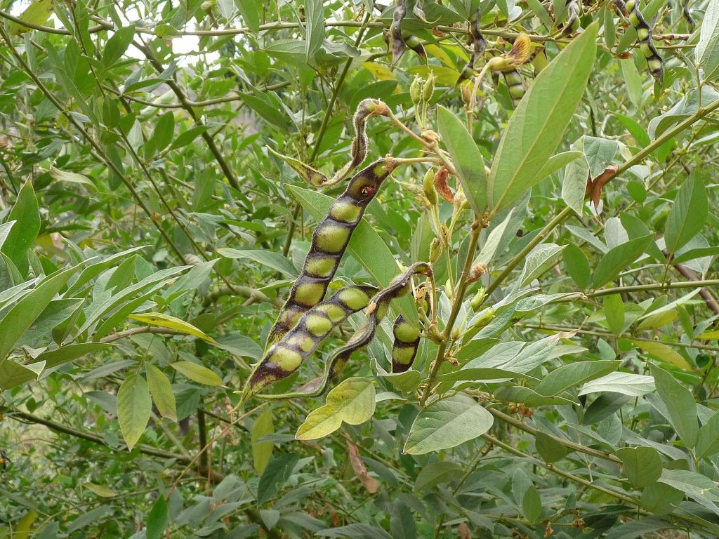
The permaculture principle that asks us to value the marginal has already positioned permaculture projects in disturbed locations, and many well known techniques practiced by permaculturists have been developed for disturbed and degraded landscapes. Examples are the use of pioneer species like nitrogen fixing ground covers and herbaceous perennials to rapidly cover exposed soil and create the conditions for further successional species. Pigeon Pea (Cajanus cajan) is one example of a tropical nitrogen fixing plant that grows rapidly while producing an edible seed. The plant can be perennial and last for up to five years, setting the stage for the next species to be planted in an intentional succession. Pioneer species like Pigeon Pea can be planted swiftly, and then occupy the accessible light and root zone so other undesirable plants don’t become established during recovery while resources are being gathered for longer term plantings.
As was mentioned before, root crops by nature have their energy stored in roots. The fact that root crops are edible is even better. Some can be easily divided and spread in the aftermath of a cyclone disturbance event. Erle Rahaman-Noronha of Trinidad related this about root crops in tropical cyclone recovery scenario: “Cassava will work well as it can plant almost any time of the year as long as there is a little moisture, and will be harvestable in 9-12 months. The young leaves can also be cooked and eaten. Sweet Potato slips will produce tubers the quickest, in 4 months and are fairly easy to propagate. Other root crops like Taro and Tania are also easy to propagate but they tend to grow best during the rainy season and go into hibernation during the dry season. So depending on when the hurricane hits, production may not be as good.”
The diverse permaculture landscape should already contain much of the plant material for the next stage of succession to be sourced from. Rooted cuttings, root division, air layering, stool beds, grafting, and other plant propagation methods can be used to multiply existing resources.
Seed banks are also essential. The truth is that recovery from a disaster needs to be a community undertaking, and cooperation is a key ingredient for preparation, survival, and recovery. Community scale seed banks are the best option, as everyone is simultaneously recovering from a big storm, and it’s a perfect time for good ideas and beneficial plants to spread within a community.
- “Typhoon? Hurricane? Cyclone? Here’s the Difference”. CBS News. 11 Nov. 2013. Web. Feb.2018 https://www.cbsnews.com/news/typhoon-hurricane-cyclone-heres-the-difference/ ↵
- “Global Warming and Hurricanes: An Overview of Current Research Results”. Geophysical Fluid Dynamics Laboratory. 24 Jan. 2018. National Oceanic and Atmospheric Administration. Web. Feb. 2018 https://www.gfdl.noaa.gov/global-warming-and-hurricanes/ ↵
- Hopewell, John. “Hurricane Maria Decimated the Nation’s Only Tropical Rainforest Outside Hawaii”. The Washington Post. 29 Sept. 2017. Web. Mar. 2018 https://www.washingtonpost.com/news/capital-weather-gang/wp/2017/09/29/hurricane-maria-decimated-the-nations-only-tropical-rain-forest/?utm_term=.3ae9ef436cd3 ↵
- “Lessons From Ike: Cuba Gets Evacuations Right: Low Death Count Attributed to Island’s Efficient Hurricane Response System”. Associated Press. 10 Sept. 2008. Web, Mar. 2018 http://www.nbcnews.com/id/26647041/ns/world_news-americas/t/lesson-ike-cuba-gets-evacuations-right/#.WpmOLhPwb8s ↵
- “Lessons From Ike: Cuba Gets Evacuations Right: Low Death Count Attributed to Island’s Efficient Hurricane Response System”. Associated Press. 10 Sept. 2008. Web, Mar. 2018 http://www.nbcnews.com/id/26647041/ns/world_news-americas/t/lesson-ike-cuba-gets-evacuations-right/#.WpmOLhPwb8s ↵
- Robles, Francis, and Jess Bidgood. “Three Months After Maria, Roughly Half of Puerto Ricans Without Power”. The New York Times. 29 Dec. 2017. Web. Mar. 2018 https://www.nytimes.com/2017/12/29/us/puerto-rico-power-outage.html ↵
- “Major Hurricane Harvey”. National Weather Service. 25-29 Aug. 2017. National Oceanic and Atmospheric Administration. Web. Feb. 2018 https://www.weather.gov/crp/hurricane_harvey ↵
- Masters, Jeffrey. “Storm Surge Reduction by Wetlands”. Weather Underground. Web. Mar. 2018 https://www.wunderground.com/hurricane/surge_wetlands.asp ↵
