8 Drought, Heat, and Erratic Rainfall
Threat Summary
The impacts of drought, heat, and erratic rainfall are varied, and have differing effects on urban and rural populations. In this section we will primarily focus on the effects on agriculture because maintaining food production through extreme climatic events is critical to the existence of stable societies.
One of the main effects of climate change apparent in many different climate zones is the change in regular rainfall patterns[1]. This is especially impactful for farmers who depend on rainfall to determine sowing and harvesting periods. Correctly timing rainfall based agricultural activities is even more critical in arid and semi-arid climates with very short cool and wet seasons.
Erratic rainfall patterns can mean both an increase and decrease of precipitation amounts. Decreased rainfall and drought can cause low yields and crop failure, depletion of surface and groundwater irrigation supplies, depletion of domestic water supplies, and an increase in wildfire potential (which will be discussed in a later section). Drought is a slow motion disaster, as water resource depletion is not a singular event; it builds as rains fail, heat increases, and supplies are exhausted.
Extreme rainfall events are also on the rise, and can be more of a fast motion disaster, with flash flooding and the resulting soil erosion. In rainfall dependent dryland agricultural systems, rapid loss of topsoil from an extreme rain event can prove catastrophic. If a farmer is not prepared for the undulation between extreme heat, drought, and extreme episodic rainfall events, then it can spell disaster through crop failure, topsoil loss, and infrastructure damage.
A change in the length of seasons also creates risk because certain crops require particular temperature thresholds to survive and thrive. A rise in temperature can mean both a shortening of cool seasons and lengthening of warm seasons. This affects sowing and harvesting times as well as the general viability of certain crops.
With the combination of irregular extreme heat spikes, varied season length, and erratic rainfall patterns, farmers who have historically relied on predictable planting calendars and irrigation schedules can find themselves in unfamiliar new conditions that are hard to predict and plan for. Data from the US has seen a steady increase in the length of the growing season for the contiguous 48 states, and the influence on planting times is obvious. [https://www.epa.gov/climate-indicators/climate-change-indicators-length-growing-season]
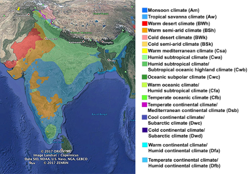
One region that we will be examining in this chapter is the Thar Desert in Rajasthan, India, where it’s been measured that the cool season is decreasing while the warm season is lengthening. At the same time the length of the monsoon season is decreasing while the total rainfall amount is increasing with greater deluges from monsoon rains[2].
For communities to survive these sorts of complex changes, solutions have to be deeply integrated as well as widespread throughout a region to make any impact on overall food and water security.
Extreme Event Survival
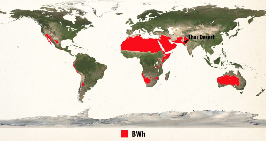
Surviving the acute effects of drought, extreme heat, and erratic rainfall is something that communities located in extreme climate conditions have to deal with on a regular basis, so there is a lot to learn by studying their habits, practices, and rules. The Thar Desert in Rajasthan, India, is the most densely populated area with a Warm Desert Climate (BWh) on the planet, with a population of around 25 million people and a population density of 83 people per square mile. Traditional knowledge and practices are adapted to the extreme conditions and have lead to a historically stable agricultural system in this marginal region.
In Rajasthan, there is a local saying about what climate conditions can be expected over long time periods. This was related to me by Rajendra Kumar, the senior program coordinator of the NGO GRAVIS Jodhpur, whose mission is to work with desert communities for the empowerment of the poor. The saying is that in a century of 100 years, there are 27 years of good rainfall. Another 63 years are mixed with some production. There are 7 years of drought, and 3 of extreme drought when even mothers and children separate, never to meet again[3].
In the Thar desert it is considered a good year when rainfall is greater than 20% of normal, so greater than 250mm (10”). A mixed year is when rainfall is between 150-250mm (6-10”). A drought year is between 100-150mm (4-6”), and the severe drought is below 100mm (4”), possibly down to 0 if rains fail completely.
This extreme drought condition is known locally as Trikal and is characterized by lack grain for food, fodder for livestock, and water for basic domestic needs. When it is said that if mother and child become separated they will never meet again, it is representing complete societal breakdown, where people are wandering in search of food and water to avoid dying of thirst and starvation. This condition is said to happen three times in a century, so you can only imagine the cultural memory of those years and how much that shapes the conservation and stockpiling of resources during good years. The Thar Desert area has been continually inhabited since it became a desert between 4,000-10,000 years ago[4], so this 100 year breakdown is coming from very real long standing observation.
Because of the extremely harsh conditions in the Thar Desert, the culture is built for survival with long term vision, strategy, and coping mechanisms. They manage both private and community resources for survival, and have developed a Common Property Resources bank (CPR). This bank is not full of money, although villagers have also developed their own financial systems. It is comprised of the essential elements for their survival.
The types of resource storages listed below demonstrate the way in which one society has coped with extreme conditions. The details will change in different regions, but the principal of stockpiling resources for survival during lean times remains the same:
- Grain bank: This is surplus grain storage on a community level.
- Fodder bank: Fodder is cut and stored in large piles at each village hamlet.
- Firewood bank: Wood is gathered and stockpiled at the family and community level.
- Water bank: Water resources are developed and are stored at both the community and the family level. Water is stored in home reservoirs for domestic use, as well as in larger wells and ponds developed with community labor and financial resources. The wider water resource that is developed as the accumulation of many small and medium scale water harvesting projects is groundwater, where water is pulled out for irrigation.
- Vegetable bank: Vegetables are cultivated in irrigated lands where the water table has been built up enough to provide water even in dry years.
- Seed bank: Climatically appropriate seeds are saved at the domestic and community levels.
- Tree and shrub banks: There are five keystone tree and shrub species that represent the foundation of indigenous survival which are conserved as a rule throughout the Thar Desert. These are trees that provide essential food, fodder, medicine, fuel or material for the people, and as perennials, are plants that remain productive throughout drought and extreme drought years. The species are the sacred Khejri Tree (Prosopis cineraria), Ker Tree (Capparis decidua), Gum Acacia (Acacia Senegal), Phog Shrub (Calligonum polygonoides), and Rohida Tree (Tecomella undulata). Reverence and protection for these species is a matter of religious significance, and they are conserved on both community lands as well as private farms, insuring a base level of food security during drought years.
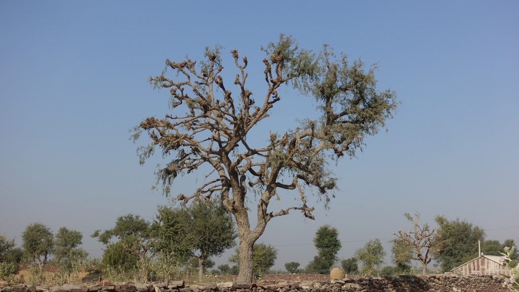
The sacred Khejeri Tree (Prosopis cineraria) is pruned each year for fodder, building the bank that will feed animals into dry seasons.
Site mitigation plan
The below list of simple drought resilience strategies represents an excellent collection of guiding directives to follow in adapting a site to drought, extreme heat and erratic precipitation. This list was provided by Ardhendu S. Chaterjee, who is the executive director of an NGO called Development Research Communication and Services Centre located in West Bengal, India, where they have impacted over ¼ million rural villagers since their work began in 1982. I have provided an expanded explanation for each topic heading. Overall, this is a design checklist for a site mitigation plan.
1. Store water from all precipitation and surface flows.
This brings us back to permaculture site analysis 101. What is the watershed of your design site? What are the impermeable surfaces and places where water is running off? Where does water enter and leave the site? Where can water be slowed, spread, sunk and stored?
2. Reduce irrigation with pumped up deep level groundwater.
Groundwater may or may not be a renewable resource. It depends on if water within the basin is being infiltrated in a healthy watershed. If the hydrologic cycle is broken, then pumping deep groundwater can deplete aquifers and degrade water resources.
3. Reduce areas under crops requiring frequent & intensive irrigation.
This is about the appropriate choice of plant types and varieties. The world over, people are growing water intensive crops in places that do not have the long term water resources to support those crops. This is how aquifers collapse!
4. Select plants and animals accustomed to heat stress and occasional dry spells.
Locally and regionally adapted species and varieties, or varieties of plants and animals that are regionally adapted within an analogous climate are the best bet to planting and rearing appropriate species and cultivars.
5. Reduce the use of petro-chemicals & other fossil fuel based machinery used in the farm for tilling soil, lifting groundwater, post-harvest processing etc. both in and around the farm.
Reducing the energy footprint of farm operations lessens dependence on fossil fuels, which may be imported from far away and be a weak link in overall resilience due to distant supply lines. Reducing fossil fuel usage also lowers the carbon footprint of operations, lessening global climate change.
6. Reduce soil erosion by physical and biological means.
Soil erosion is caused by wind and water flow, as well as mechanical and biological means, like hoof action from grazing animals. Soil is the basis of terrestrial agriculture and conserving and building soil is a foundation of successful agriculture.
7. Reduce exposed soil surfaces.
Covered soil is more biologically active, and can thus hold more moisture. Soil that is exposed to the sun, wind, and falling raindrops is more prone to erosion and dehydration.
8. Enhance the water holding and carbon sequestration capacities of soil to improve productivity, soil structure, and reduce the need for tillage and aeration.
A healthy soil biology will accomplish all these things. Covering soil and protecting it from erosive forces is the first critical step to building and maintaining healthy soil biology.
9. Diversify sources of income based on agro-residues and byproducts.
The permaculture principle “Produce no waste” is about seeing waste as a resource. Agricultural residues and byproducts could be potential income generating materials if viewed as resources and used innovatively.
10. Cultivate various tree products and parasitic/pollinating insects.
Perennials are more resilient overall to yearly fluctuations of water availability because of their established root systems, especially if those trees, shrubs, herbs and grasses are climatically appropriate species. As we saw in the section “Survival” above, in the Thar Desert, five species of native perennial trees and shrubs make up the foundation of food security during drought years.
Another strategy to add to this list that is being implemented in the Thar desert relates not to increasing heat and drought, but to increasing intensity of storms and the threat of flash flooding. Although the rural landscape is fully designed for water harvesting and water infiltration to build groundwater resources, flooding is also accounted for through several strategies:
- Overflows on water harvesting structures are robust and sized for large scale rain events.
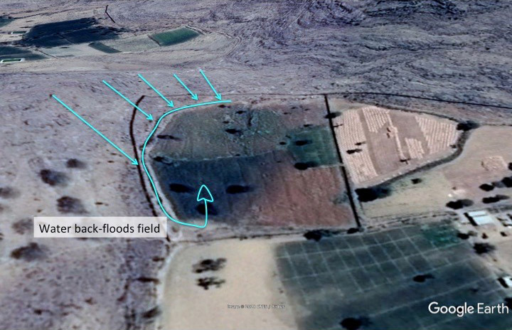
- Water flow within farm fields is channelized so flood flow does not spread out within fields and damage crops. Although channelizing water can be dangerous in many circumstances because of the erosive power of concentrated water, stabilizing the channels is critical when water is being channelized.
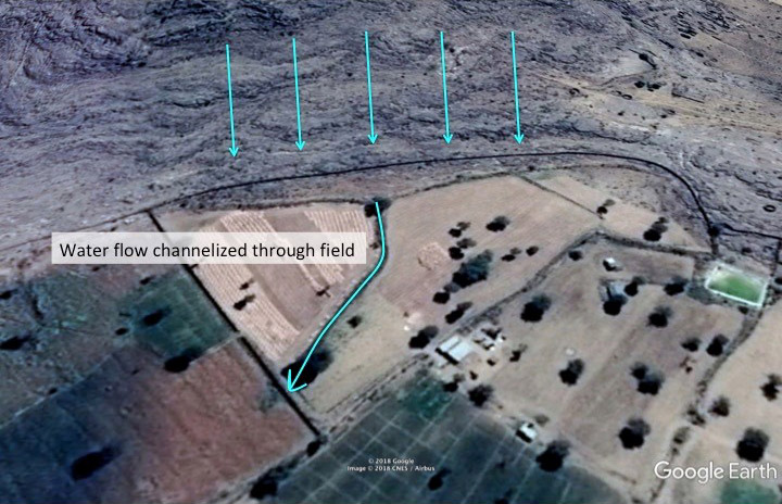
Figure 52: Water Flow Channelized Through a Field - Water flows are sometimes brought into a field at the embankment at the bottom of the field, so water can backflood into the field, to avoid damaging flows from the top to bottom of the field
Designing a site to be resilient to the many faces of climate change is complex. Doing so requires accounting for drought and intense heat, as well as intense storms and flooding, and then fire. To design communities to withstand the multiple layers of threats demands an integrated and multi-faceted design system like permaculture. First natural forces are assessed, and then the design responds to those forces for both protection and utilization. But true resilience does not happen within the boundaries of one site. It happens by planning at the scale of communities and regions.
Regional mitigation
It’s important to expand out to regional scale planning, because that’s really where a community and region will become resilient. Working at the individual site level is important, but if civilization is to weather the storm of climate change and actually transition to life in an altered climatic system, then work will need to happen at the highest levels of governments and organizations to cooperate in regional and national strategies.
Watershed-scale planning
The perspective that needs to be adopted is water resource development at the watershed scale. When food and water security are addressed at that level, then planning can lead to actual resilience. Take some of the work in Rajasthan for example:
The NGO GVNML based in the village of Laporiya has been working on village scale water harvesting projects since their inception in 1977. They have now created water harvesting projects in 58 villages, affecting the livelihoods of over 115,000 people and managing nearly 450 square miles with water harvesting structures. In many cases, water harvesting structures are interlinked between villages, sometimes in chains of up to eight villages, where the overflow from one village’s structures are channeled into the next village. They have literally built the groundwater resources over an entire region, where they now pull out stored groundwater for irrigation and grow a winter crop in addition to the summer crop planted with the monsoon rains.
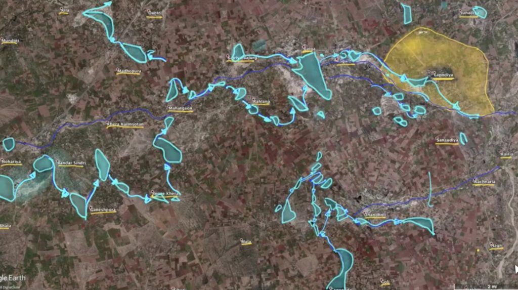
Water harvesting structures are interlinked between villages to harvest intense monsoon rains during 2 months of the year for use during the 10 dry months. Satellite photo is from after the monsoons, where major water harvesting structures are full and visible.
Groundwater resource development
At that scale, they are undertaking groundwater resource development. Jagveer Singh, the executive director of GVNML and the brother of its founder states that if they have one good year of rains and fill their extensive water harvesting structures in his village of Laporiya, then they will store enough groundwater to last through three dry years. They have rules about conservation and what crops can be grown during dry years, as well as rules about maintaining tree cover and setting aside land for wildlife. The rules are posted throughout the village to remind everyone of their agreements.
GVNML is working in 58 villages in a warm semi-arid climate (Bsh), and estimates the amount of land that they have under water management to be 450 square miles (1150 square kilometers). With interconnected village water harvesting systems at this scale, it is at the level of regional groundwater recharge. The work of GRAVIS Jodhpur is at an even larger scale in a warm desert climate (Bwh), where they the area around 1,200 villages under water management. Both of these organizations working at this scale have literally altered the hydrology, agriculture, and culture of their regions through their work. That’s true permaculture!
Reforestation
Along with regional groundwater recharge and improving the soil’s capacity to hold water comes another important aspect of restoring the hydrologic cycle and stabilizing climate, and that is reforestation. As previously mentioned, trees and shrubs can provide food security in arid lands, and can also help to increase rainfall. This occurs by trees transpiring water into the atmosphere which then combines with atmospheric moisture to produce precipitation. The effects of deforestation on precipitation are well established[5], and this trend can be reversed by establishing forests on degraded and desertified lands. Establishing new forests goes along with conserving existing forests and strategically blocking desertification through water harvesting, erosion control, and reforestation.
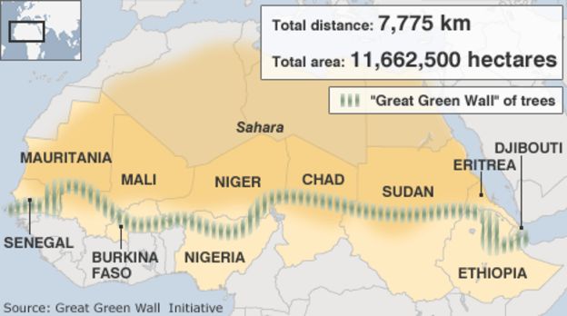
Some well known examples of this are Africa’s Green Wall, where the aim is to establish a belt of trees at the Southern border of the Sahara Desert[6].
China’s regreening of the Kubuqi Desert, which was born from the business need to transport salt across a blowing sandy desert that was constantly making roads impassable for transport.
The reforestation of the Loess Plateau is another massive scale reforestation project, popularized by filmmaker John D. Liu that has had a huge impact on the agriculture and hydrology of the region.
Forests are not however the answer for every arid ecosystem on the planet, and each situation needs to be examined individually. There are ecosystems where it appears more appropriate to manage for soil cover using perennial grasses than trees. One example is the Western Juniper (Juniperus occidentalis) woodlands covering areas in eastern and central Oregon, and the situation is similar in much of the arid western United States. Junipers used to be confined to rocky ridges, and as they spread down into slopes and lowlands since the 1880’s, springs dried up and low growing grasses and forbs disappeared. It was measured that the evergreen Western Junipers in that instance were intercepting 70% of the rainfall and it never hit the ground. When the trees were removed and the ecosystem transitioned to perennial grasses, soil moisture increased, as well as the amount of water flowing through streams and springs. [7] So encouraging every arid ecosystem towards a climax forest as a blanket strategy is not wise. There are unique dynamics to every ecosystem and species which need to be studied, considered, and tested.
Recovery
Drought is not a singular destructive event that a region would recover from, like a wildfire or hurricane. It is more of a persistent long term disaster that needs to be permanently adapted to. Areas that are prone to drought should be consistently building and storing essential resources as mentioned above to be ready to endure through the next dry spell or heat wave.
There are particular events within droughts that have an element of disaster, like extreme heat waves. Often times extreme heat threatens the lives of people, livestock, and wildlife. They also create the conditions for wildfire, which will be discussed in the next section.
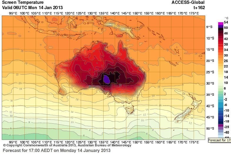
Extreme heat events are disastrous, and make headlines like this image when Australia had to add a new color to the temperature map:
They can lead to crop failure, road and equipment damage, and tree and shrub mortality. There is not a quick fix for recovery from intense heat events besides future planning choices of species and developing infrastructure to handle such events.
Erratic rainfall events are also disastrous if water harvesting systems are not designed for heavy storm flow, with properly sized channels and overflows to handle epic storm events. Recovery from topsoil loss, crop destruction and infrastructure damage will take time and resources, and the only real recovery is to be ready to capture, store, and utilize the next massive water flow episode.
New areas of soil deposition and a total saturation of the landscape could provide opportunities to get a crop in a location or at a time that was not previously anticipated, and having seed to plant after a devastating flash flood could lessen the losses from crop failure.
- Paige Ogburn, Stephanie. “Climate Change is Altering Rainfall Patterns Worldwide”. Climate Wire. 12 Nov. 2013. Scientific American. Web. https://www.scientificamerican.com/article/climate-change-is-altering-rainfall-patterns-worldwide/ ↵
- Poonia, Surendra, and A.S. Rao. Climate Change and its Impacts on Thar Desert Ecosystem”. Journal of Agricultural Physics. 16 May 2013. Indian Society of Agrophysics. Web. Jan 2018 http://www.agrophysics.in/Published/2013/S-Poonia.pdf ↵
- Katiyar, Sudhir. Rainfed Agriculture in Thar. Jodhpur: Gramin Vikas Vigyan Samiti (GRAVIS). 1990. Print http://www.gravis.org.in/images/Books/Rain%20fed%20Agriculture%20in%20Thar.pdf ↵
- Sanyal, Sanjay. Land of the Seven Rivers: A Brief History of India’s Geography. London: Penguin. 15 Nov. 2012. Print. ↵
- Webster, Bayard. “Forests Role in Weather Documented in Amazon”. New York Times. 5 July 1983. Print. http://www.nytimes.com/1983/07/05/science/forest-s-role-in-weather-documented-in-amazon.html?pagewanted=all ↵
- “Push for ‘Great Green Wall of Africa’ to Halt Sahara”. BBC News. 12 Jun. 2010. Web. Jan. 2018. http://www.bbc.com/news/10344622 ↵
- Herring, Peg. "Taking the Pulse of Water in Western Juniper Woodlands." Oregon's Agricultural Progress. Winter, 2017. Oregon State University. Web. http://oregonprogress.oregonstate.edu/winter-2017/taking-pulse-water-western-juniper-woodlands. Mar. 2018. ↵
