3 The Climate Analogue Tool
The potential benefits to locating a close analogue climate are many, and in the permaculture design process, it is a common tool used by many experienced designers. There are some really useful reasons for locating a similar climate to your own.
1) Locating plant, fungi, and animal species that thrive in your climate and exchange of that genetic material between analogue climates.
Completely different plants, fungi and animals evolved and have been domesticated in similar climates to your own across the world. Domesticated and wild species of plants, fungi and animals have already spread out across the planet, but that does not mean that every beneficial species that can be grown is being cultivated everywhere it can be. Locally adapted varieties of fruits, nuts, vegetables, grains and livestock that are particularly suited to their place may also be particularly suited to yours!
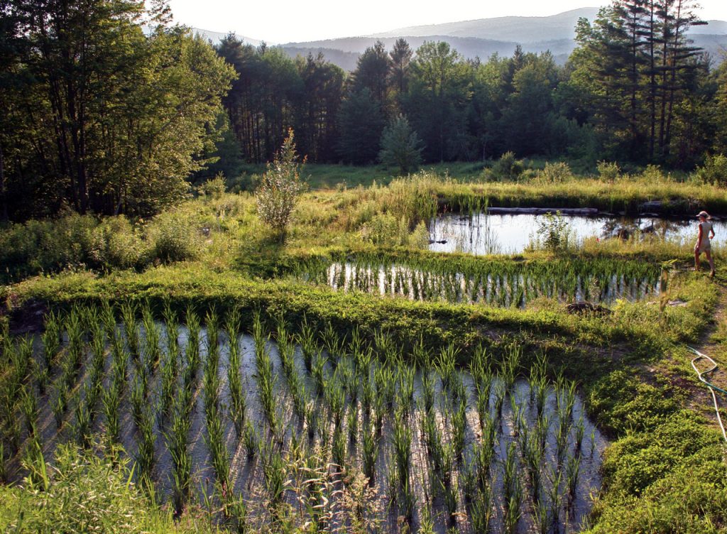
A great example is the cultivation of cold-climate rice by Ben Falk in cold climate Vermont, USA (USDA zone 4). Even though rice is typically grown in warmer regions of the US like the Lower Mississippi river basin in Arkansas and Louisiana, Ben observed that Northern Japan was a climate analogue to Vermont, and that there were traditional rice varieties growing in Japan all the way up to 44 degrees North latitude[1], which is the same latitude that Northern Vermont is located.
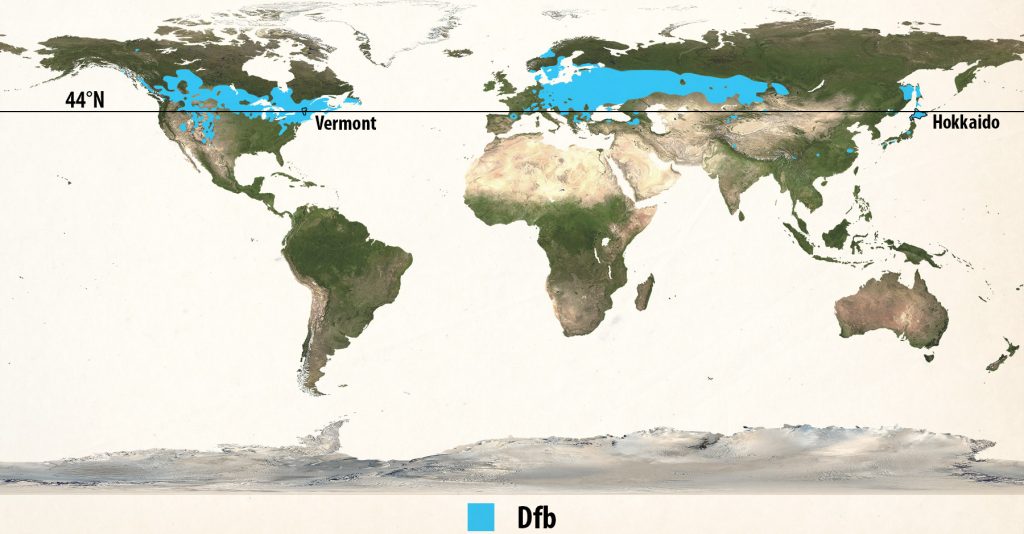
Ben began planting Northern Japanese rice on his farm and has been successfully growing it there since 2010. What other useful species are growing in Northern Japan that have never been introduced to Vermont? Much of Eastern Europe, Southern Scandinavia and Southern Russia are also in the same Koppen-Geiger climate classification. What plants, animals, fungi and practices could assist a regenerative agricultural system in the NE USA? These are the questions that the climate analogue tool helps to answer.
2) Understand the climate of a place you’ve never visited.
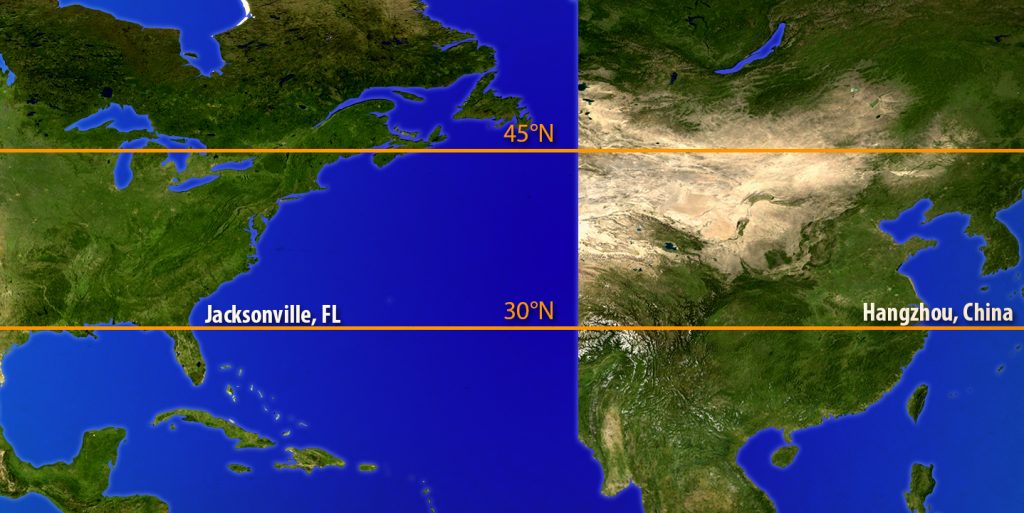
This is particularly useful for a professional consultant or designer who is doing work outside of their bioregion. I was recently asked to look at a potential design site in Hangzhou, China. The US East Coast and the Chinese East Coast share a similar latitude and coastline shape in relation to a warm water body to the south: the Gulf of Mexico and the South China Sea.
It was easy for me to figure out that Jacksonville, Florida was a close climate analogue to Hangzhou, with the same latitude, elevation, and proximity to the water where a major river enters the ocean. Finding resources about the region around Jacksonville gives me a really good starting point from which to study Hangzhou because I can see what the major crops, practices and plant and animal species are that are from its analogue. It’s not just Jacksonville and Hangzhou. The entire US East Coast and Chinese East Coasts are mirrors of each other in so many ways.
3) Understand horticultural history for plant breeding and microclimate development
When we understand the climatic similarity of different regions, history can suddenly make a lot more sense.
One of the oldest cases of genetic evolution of an Asian fruit variety in North America is the Peach. When Spanish conquistadors arrived in New Mexico and Arizona starting in 1540, they built missions in the Rio Grande river valley and in the Pecos, Hopi and Zuni pueblos.They brought fruits familiar to them: Peaches, Apricots, Apples, Pears and Grapes, and Native Americans became familiar with these at that time.
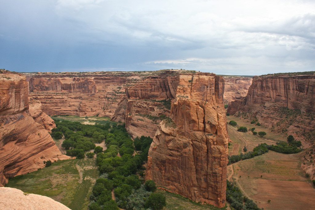
In 1680, the Pueblos rose up against the Spaniards in the Pueblo Revolt, and drove them out from their lands. The tribes at some point adopted the exotic fruit trees and began planting peach seeds, and have continued planting them to this day, centuries later. These trees have become very adapted to the Bsk Cold Semi-arid climate, famously growing in Canyon De Chelly on the Navajo Nation in NE Arizona where in 1863, the US government led by Kit Carson burned thousands of these trees from the canyon in an effort to force the Navajo out.
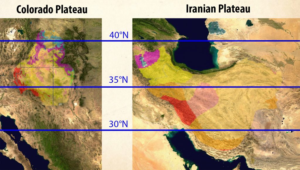
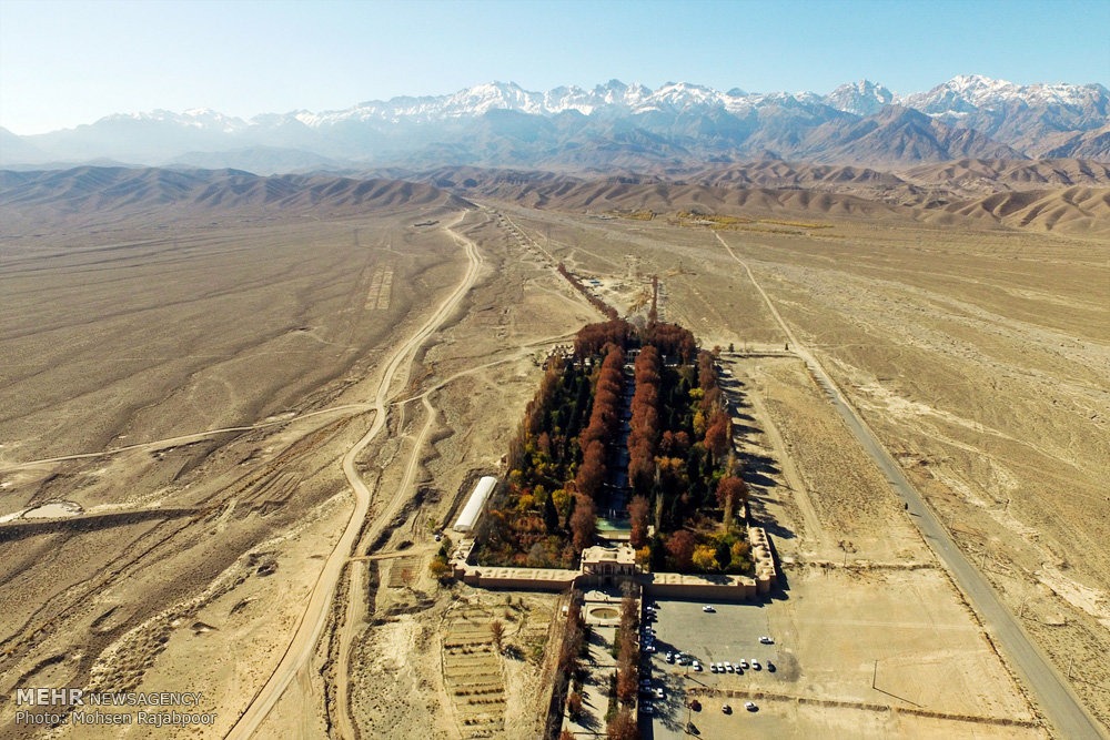
Peaches in a high desert canyon aren’t the typical images of the Georgia or California crops in lush irrigated agricultural lands. But when we look at the migration route of peaches from their origins in China and along the Silk Road to Europe, we see them becoming established in the walled paradise gardens of the Iranian Plateau. And when the climate types are examined, it becomes apparent that the Iranian Plateau and the Colorado Plateau are strikingly similar in climate type, latitude, elevation, continental positioning, and topographic variation. The canyon walls that shelter trees in the Four Corners of the US are liken to the walls that enclose the gardens of Iran. The peaches found their analogue climate and conditions from earlier on their migration route.
4) Vernacular architecture and innovative engineering
Developing climatically appropriate buildings is another area where the climate analogue tool can be very useful. Studying the housing and construction styles of an analogue climate can reveal profound human ingenuity in adaptation to climatic conditions.
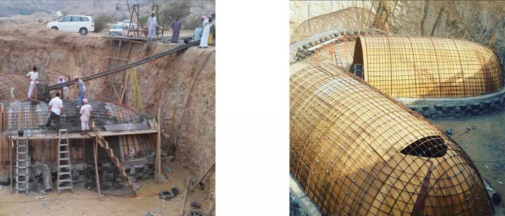
A stark example of this takes us to the Al Baydha project in Saudi Arabia and their development of underground housing. The project was initiated by the Kingdom of Saudi Arabia in order to create a viable settled livelihood for the traditionally nomadic Bedouin people, and we will be examining various aspects of this project throughout this book.
The underground homes of the Berbers in Tunisia are well known in modern culture for their influence on Luke Skywalker’s childhood home on Tatooine in the movie Star Wars.
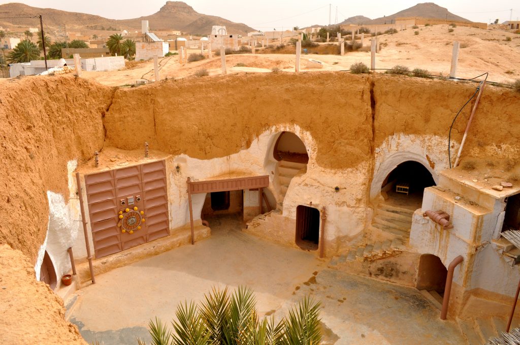
Tunisia is Bwh, hot desert, and a climate analogue of Saudi Arabia. The Al Baydha project imported this style while adapting it to modern and available construction techniques and materials like tires, rebar and concrete, and created their version of the Berber house.
5) Innovative engineering
Irrigation methods is another huge field with knowledge to be gained by studying analogue climates. One common example of a technique now used in North America in hot desert climates is watering through a buried unglazed clay pot where the water trickles through the pot directly into the root zones of adjacent plants. This method was originally developed in North Africa and is still used by traditional farmers in the Middle East and India today[2].
This method for water saving irrigation has been transported from analogue climates in the East over to the Western hemisphere where it is widely practiced among drylands Permaculture practitioners.
There are many more examples of methods that have been copied from their original innovators over to their climate analogues, and there are many possibilities for this technology exchange that have not yet been done. Study of the practices of one analogue can yield very useful methods for another.
6) Cultural practices and Folk Wisdom
Often times, the folk wisdom of a society represents a great deal of trial and error and practical lessons learned in a place that have been passed down for many generations. As practical wisdom is learned, it morphs into written stories and oral traditions over time. Studying the anthropological aspects of cultures of analogous climates is rich with possibilities for learning how to best relate with a given climate type.
For example, if one looks at the geographic distribution of the “siesta”, or afternoon nap, we see that it is in places where temperatures rise steeply in mid-afternoon. People wake up early, have a big lunch, and then nap during the hottest part of the day, returning to work when temperatures cool down later. So the cultural patterns in areas like Spain and Southern Europe were translated over to analogous climates in North and South America, and the siesta became a cultural practice transferred along analogous climates.
How-to Find a Climate Analogue
The most basic elements of a climate type are temperature, precipitation, and seasonality of precipitation. All of the other climate ingredients are part of the recipe that brings us to those basic elements. This is what Koppen understood when he developed his climate classification system, so this is an excellent place to start when locating a climate analogue. Not all regions have equal information about them available, and this can be a challenge. Regions that contain good climatic, agricultural and cultural data about them make the task of locating a climate analogue much easier.
1) Identify your Koppen-Geiger climate classification.
What is the 3 letter Koppen-Geiger code of your site and what do the letters represent? You should be able to look at the Koppen-Geiger map and identify the color that represents your climate class. {Hint: on the Koppen-Geiger page of Wikipedia, you can click on each climate class to go to a map that shows only that climate zone on an otherwise white map. Very easy to read.}
2) Look for areas within 10 degrees North or South of your latitude.
Study the map for other locations with the same climate classification as your site that are within 10 degrees latitude of your site, or the mirror image in the other hemisphere. The closer that you can get to your latitude, the better. By this point you should have some options identified to look more closely into for the remaining steps.
3) Look for areas with the same proximity to water; oceanic or continental.
Of the areas that interest you as potential climate analogues, assess their proximity to the ocean or other large body of water. What are the similarities and differences between your site and this potential analogue climate? Are both locations on the same coast East or West, North or South?
4) Compare Koppen-Trewartha classification.
What is the 2 letter Koppen-Trewartha code and what do the letters represent? Cross-reference the Koppen-Trewartha classification map to see if there is any difference between your site and its potential analogue. If the Trewartha map shows that your two comparison sites are in different climate classes, then go back to the beginning and find a new potential analogue to assess.
5) Compare elevation.
What is the elevation, in feet or meters, of your design site and potential analogue site?
6) Compare precipitation amounts.
What is the average annual precipitation, in inches or millimeters?
7) Compare precipitation seasonality.
When during the seasons of the year does precipitation typically arrive?
8) Compare Thornthwaite climate classification.
What is the Thornthwaite climate classification which is based on precipitation and evaporation rates? If these are very different, you may want to reconsider this location and try another.
9) Compare global air circulation and storm tracks.
Are there particular air circulation patterns that affect the timing and qualities precipitation, winds and storm events? (i.e. monsoon, seasonal hurricanes, oceanic jet stream etc.)
10) Compare nearby ocean currents (if applicable).
Are there particular ocean currents that affect temperature and seasonal weather events? (i.e. North Atlantic Current bringing warm water North or California Current bringing cold water South etc.)
11) Compare topographic features and landscape positioning.
Are there mountain ranges or major rivers in the region? What are they called and what are their elevations in feet or meters? If there are topographic features present, what is the proximity of the site and directional relationship to them (North, South, East or West)? Is there a major plateau, delta, are you on an island? Are there other distinctive feature that characterizes the area?
12) Compare average temperatures.
What are the yearly average high or low temperatures of the site in degrees Celsius or Fahrenheit?
13) Compare plant hardiness zones.
What is the plant hardiness zone of the site in degrees Celsius or Fahrenheit? This has to do with the average low yearly temperature.
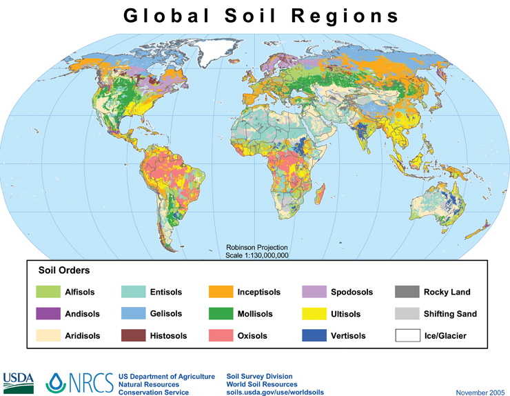
14) Compare soil types.
More than likely the global soil regions between two analogue sites will be the same because climate strongly dominates the soil forming process.[3] If the soil regions are not the same, that may be something to examine. For instance, if the sites have dramatically different soil regions, with one site having sand dunes and the other clay, this means that geologic forces are a dominant characteristic and it could have an impact on the analogous nature of the sites.
At this point, you should be confident about your analogue climate. Ponder what the major differences there are between the two climates. Now it’s time to research and really see how things are being done in your climate analogue:
- What are the major crops grown in the region?
- What types of interesting plant, fungi and animal species are present?
- What is the vernacular architecture and building materials used traditionally?
- What do people use for energy sources?
- What type of water distribution and irrigation are used?
- Are there any cultural practices of interest?
- “Japan”. Ricepedia. Consultative Group for International Agricultural Research (CGIAR). http://ricepedia.org/japan ↵
- Bayuk, Kevin. “Ollas: Unglazed Clay Pots For Garden irrigation”. The Permaculture Research institute Australia 26 Sept. 2010. Permaculture News. Web. Jan. 2018 ↵
- Bailey, Robert G. “Ecoregions: The Ecosystem Geography of Oceans and Continents” Springer-Verlag New York, 1998, p 39 ↵
