Mojave Desert Ecosystems
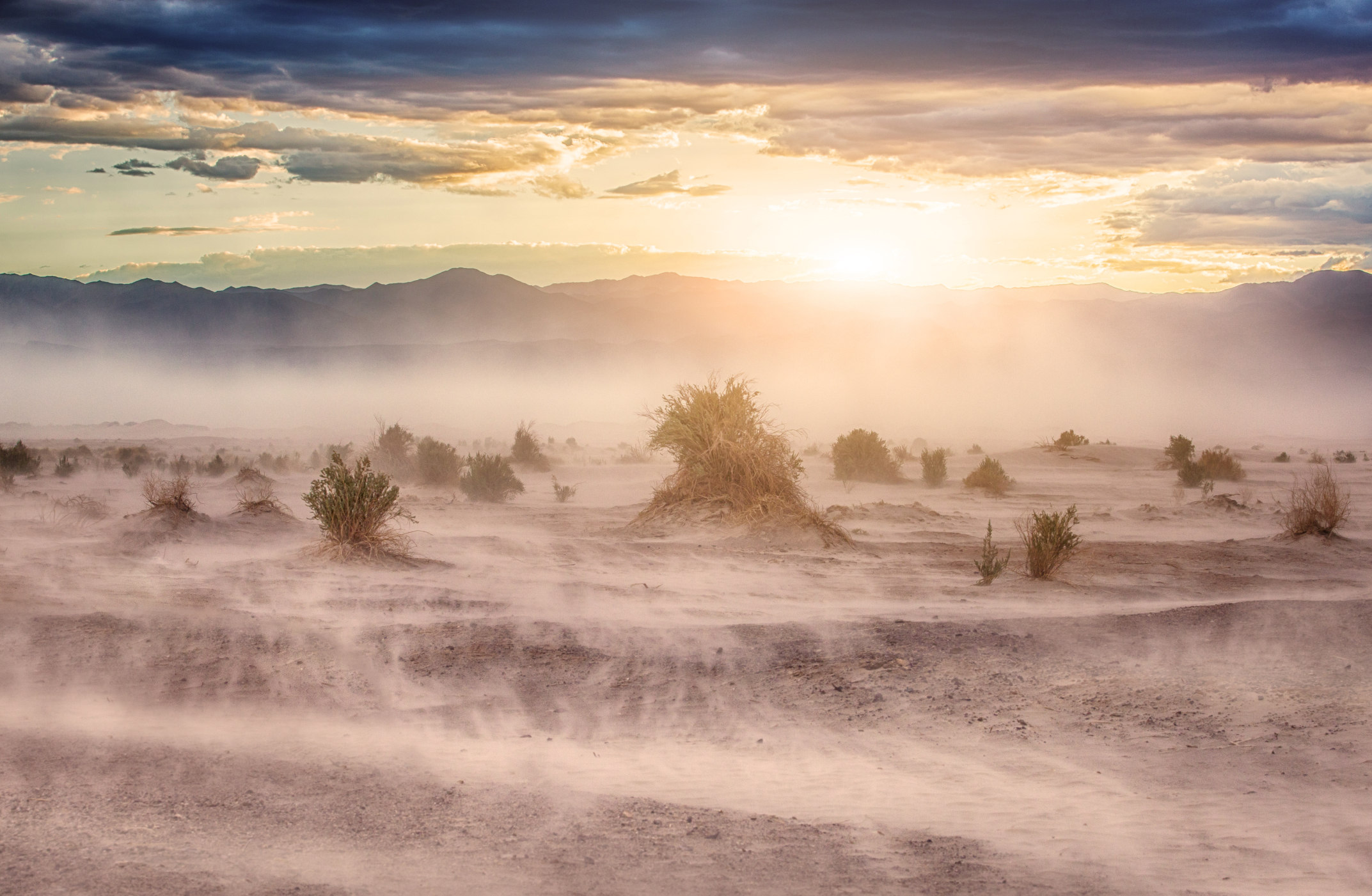
The Mojave Desert is the driest of the North American deserts, so after adequate winter precipitation spring wildflower blooms like the one in the image above are a spectacular event. This desert is one of the top destinations for tourists visiting the western United States, with some six million visitors annually to destinations such as Joshua Tree National Park, Lake Mead, and Death Valley, as well as the largest off-road vehicle area in the world in Johnson Valley. One-third of the species in the Mojave Desert are endemic. Increasing the pressure on this extremely arid and sensitive desert area are the impacts of urbanization, heavy recreational and military uses, mineral extraction, and large-scale alternative energy production.
Section 1: Physiography
Geographic Location and Topography
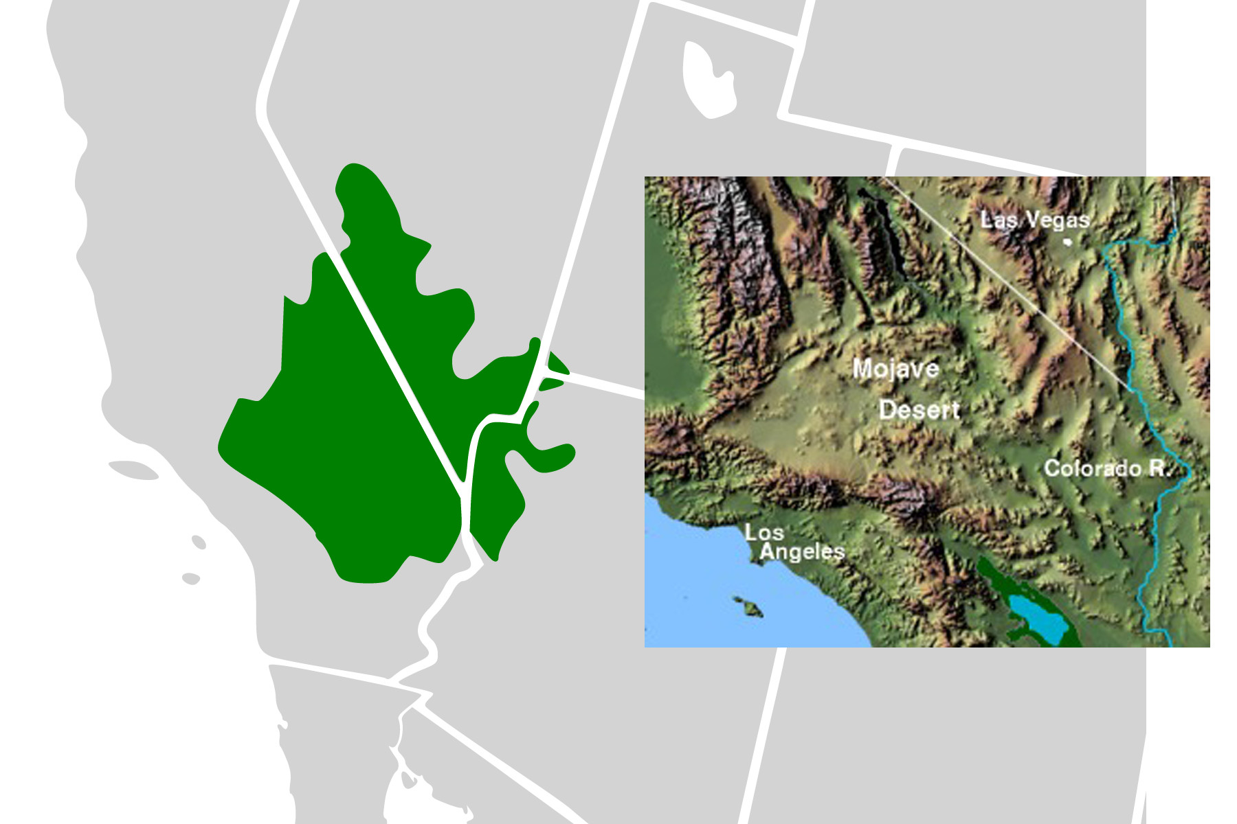
The Mojave Desert extends over roughly 50,000 square miles largely located in California with a small area in Nevada, and even smaller areas in Utah and Arizona. It is bordered by the Sierra Nevada Mountains to the northwest; the San Miguel and San Bernadino Mountains to the west; the Sonoran Desert to the southeast; the Colorado Plateau to the east; and the Great Basin to the North (figure 10.1). Its elevation goes from approximately 280 feet below sea level at Death Valley to just over 11,000 feet at its highest point—Telescope Peak, also in Death Valley. Average elevation in the Mojave Desert ranges from 2,000 to 5,000 feet. Its position on the landscape and its precipitation regime result in a desert not of general characteristic vegetation but rather of ecotones (i.e., transitions).
Climate and Vegetation
Death Valley is well known for its extreme temperatures and aridity. In 1913 the temperature at Furnace Creek, Nevada, hit 134°F, which to this day is the hottest temperature ever recorded on Earth. Average monthly temperatures range from the upper sixties to over 100°F, with seven months out of the year in the 100° range. Less than two inches of rainfall on the Mojave Desert annually; this is largely in the form of winter storms, except in the southern areas, which are impacted by the summer monsoonal effect. The ecotone gradient, underlain by the boundaries of mountainous topography and precipitation, has resulted in the Mojave Desert having 1,700 to 2,000 endemic plant species.
Section 2: Classifications
Given the strong presence of ecotones, researchers and naturalists have divided the Mojave Desert into regions or series, depending on perspective. This section will review portions of all three Mojave Desert classification schemes: series, regions, and two Major Land Resource Areas (MLRAs).
Mojave Desert Series
Scientists Vasek (1980), then Turner and Brown (1982) outlined a classification system: creosote bush series; shadescale series; saltbush series; blackbrush series (Coleogyne spp.; all of which are distinctive in some areas but generally fill out a gradient based on elevation), and Joshua tree series.
Creosote bush (Larrea tridentata) and white bursage (Ambrosai dumosa) cover over two-thirds of the Mojave. This species association mixes in four-wing saltbush (Atriplex confertifolia) in valley areas and lower portions bajadas. On calcareous soil, there is often a creosote-saltbush association.
The Joshua tree series is defined by its namesake species, the Joshua tree (Yucca brevifoia). Joshua trees are generally found on the moister, cooler sites of higher elevations. At higher elevations this series transitions into pinyon-juniper woodland and in the southern portion it transitions into the Sonoran Desert with a mix of saguaro cacti (Carnegiea gigantea), paloverde (Parkinsonia spp.).
Mojave Desert Regions
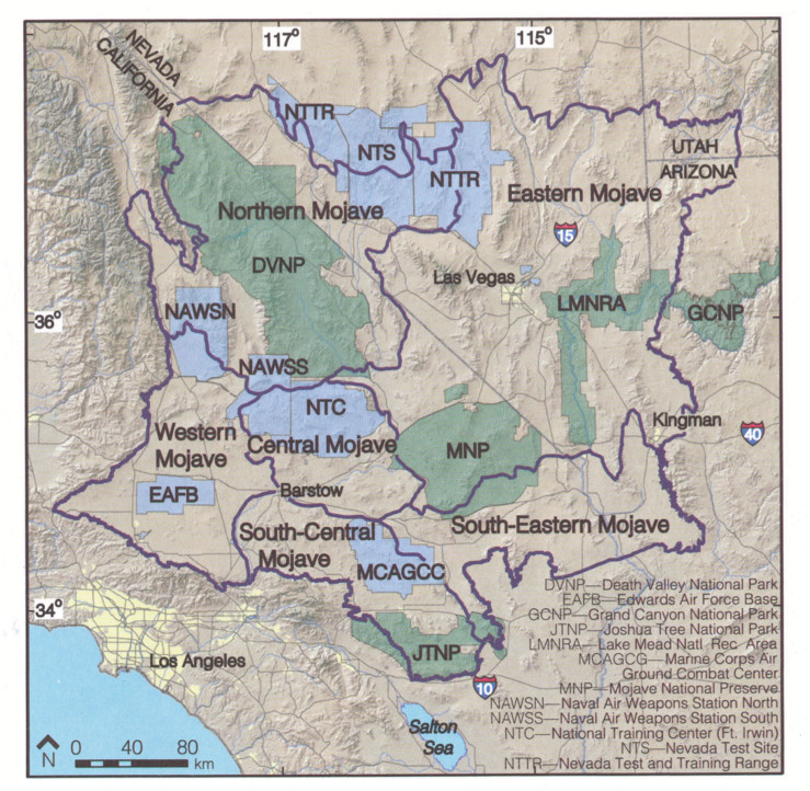
Using topography and the precipitation gradient across the Mojave Desert, Rowlands et al. (1982) proposed six general regions: northern, eastern, western, central, south-central, and southeastern (figure 10.2), all of which will be briefly reviewed in this section.
Northern Mojave is a large broad ecotone dominated by creosote and bursage assemblages and that transitions to Nevada’s Great Basin. In the southern portions of the region, Joshua tree assemblages dominate Death Valley.
Eastern Mojave, the largest of the six regions, is topographically diverse and is bounded by the Great Basin to the North; Colorado Plateau to the East; and Sonoran Desert to the South. The region is influenced by both winter precipitation and summer monsoons. Given the size, topography, and precipitation of this region, the mosaic of plant communities is substantial. In the northern high elevation areas, creosote-bursage assemblages dominate and give way to pinyon-juniper woodlands to the north and east. Southern areas are dominated by Joshua tree associations that mix with cacti and Northern Sonoran Desert plant assemblages. The region includes Las Vegas, the Mojave Natural Preserve, and the Lake Mead Recreational Area and abuts the Grand Canyon.
Southeastern Mojave is the generally topographically homogenous area bounded by the Hualapai Mountains on its eastern border. Vegetation in this region is a mix of characteristic Mojave Desert plant assemblages intermixed with northern Sonoran Desert plant assemblages, particularly in the southeastern corner, where there is a mix of both Joshua tree and saguaro cactus.
Central Mojave is the terminus of the Mojave River drainage. Topographically it is a mix of playas and broad, high-elevation valleys. Given the homogeny of topography of this area and its geographic location, it has the lowest levels of diversity found in the Mojave Desert.
South Central Mojave is bounded by the San Bernadino Mountains to the southwest and the Sonoran Desert to the south and southeast. This region is influenced by a rainfall gradient of winter storms in the west to summer monsoons in the south and east. Vegetation assemblages vary in association with the precipitation gradient, with more diversity as the region transitions to the Sonoran Desert assemblages with species such as palo verde and ironwood (Olneya tesota) mixing among Joshua trees. Given the region’s proximity to Los Angeles, impacts of urbanization, particularly in the Coachella Valley, and deposition from smog are substantial influences. Additionally, this region is home to the tourist attraction Joshua Tree National Park and a large Marine base near Twentynine Palms.
Western Mojave is bounded by the San Gabriel Mountains to the south, the Sierra Nevada to the west, and the Great Basin to the north. Given its western geographic location and proximity to mountains, it receives the greatest amount of winter precipitation of all the Mojave Desert regions. The vegetation assemblages transition from Joshua tree to pinyon-juniper woodlands.
MLRAs
The Mojave Desert is within the D Land Resource Region; an overview of the region appears in chapter 8. Given the size and location of the Mojave Desert, only two MLRAs apply to the area: D29 and D30.
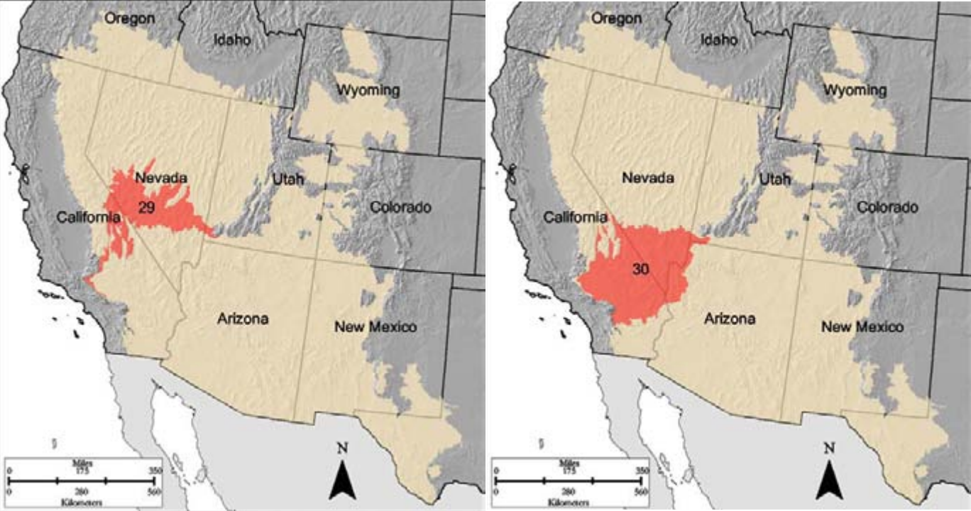
The D29 Southern Nevada Basin and Range is mostly outside of the Mojave Desert, except for a small sliver that is part of the Death Valley National Monument. This small area reflects the “shadescale series” noted above.
D30 Mojave Desert is entirely comprised of the Mojave Desert, split between the Great Basin Province to the north and the Sonoran Desert Province to the south, and is largely federally managed. Notable regarding this region is the number of closed basin playas that are often rimmed by mounds of wind-driven erosion. The playas’ bottom surfaces often have buildups of salts and minerals as a result of the quick evaporation of their shallow pools formed by winter storms or summer monsoons. Groundwater in the area generally has a high concentration of dissolved solids and high chloride levels. Soils throughout the region have what is called a thermic (warm) soil temperature regime, meaning they range from 15°C to 22°C (59°F to 71°F), another factor underlying the endemism and diversity of the region. The Mojave River flows through the region, providing, along with the Colorado, a large portion of the public water.
Section 3: Current Anthropogenic Stresses
Although the Mojave Desert is arid and hot, human presence is firmly established and continues to grow and intensify. This section will outline major areas and installations of human presence and land use, before discussing the impacts from larger issues: recreation and off-road vehicles; mineral extraction and energy production; and urbanization and atmospheric deposition. Human land uses all have the same general impacts; this section, therefore, begins with a brief, high-level overview of the extent of the human footprint in the Mojave Desert, continues with highlights from several specific types of land use, and concludes with an overview of the ecological impacts.
Human Footprint and Major Areas of Land Use
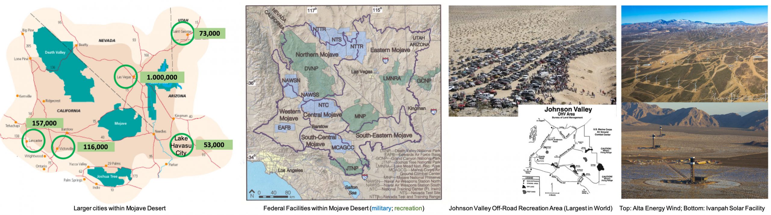
Despite the Mojave Desert being hot, dry, and water limited, over two million people reside there in several dozen cities (the largest are listed in table 10.1); about a dozen US government facilities are located within its boundaries (the largest are listed in table 10.2); several dozen energy companies have facilities there (the largest and most notable appear in table 10.3); and it contains a couple dozen heavily visited recreation and off-road vehicle areas (the most notable are in table 10.4).
| Las Vegas Metro Area (1,000,000) | Palmdale, CA (153,000) |
| Victorville, CA (115,000) | St. George, UT (73,000) |
| Apple Valley, CA (70,000) | Lake Havasu City, AZ (53,000) |
| Pahrump, NV (43,000) | Kingman, AZ (30,000) |
| Edwards Air Force Base | Fort Irwin National Training Center |
| Marine Corps Base—Twentynine Palms | Marine Corps Base—Barstow |
| Naval Air Weapons Stations (North and South) | Nevada Test Site |
| US Department of Energy Solar One | US Department of Energy Solar Two |
| Copper Mountain Solar Facility | Nellis Solar Power Plant |
| Mojave Solar Project | Antelope Valley Solar Ranch |
| Ivanpah Solar Power Facility | Desert Sunlight Solar Farm |
| Tehachapi Pass Wind Farm | Alta Wind Energy Center |
| Joshua Tree National Park | Mojave National Preserve |
| Lake Mead National Recreation Area | Death Valley |
| Las Vegas Strip and Hoover Dam | Red Rock Canyon National Conservation Area |
Off-Road Vehicles and Recreation
Outdoor recreation countrywide is more than $6 billion industry and growing. Of that $6 billion, approximately $300 million to $500 million annually is spent directly throughout the Mojave Desert, making it one of the nation’s top outdoor recreation and tourist destinations. Many consider outdoor recreation the antithesis of being tied to electronic devices, social media networks, and video games: they see it as a means of reconnecting with nature. A closer look at the ecological impacts of outdoor recreation may tell a different story, however.
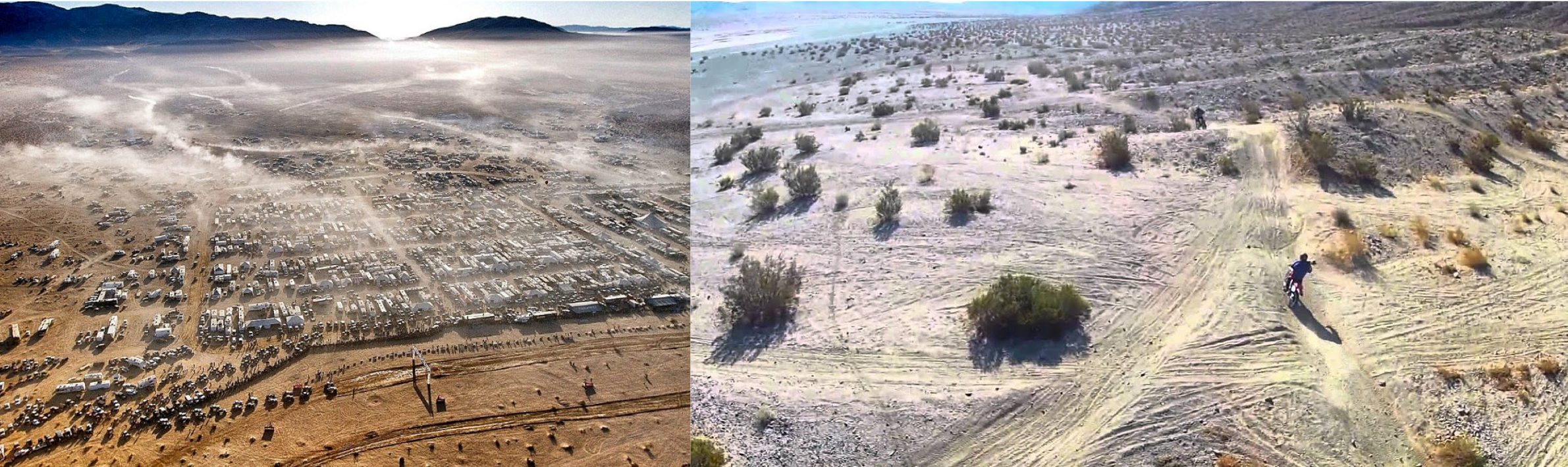
Johnson Valley
Johnson Valley, California, is the largest off-road vehicle recreation site in the world. Throughout each spring and summer, tens of thousands of off-road vehicles (ORV) and motocross enthusiasts descend on Johnson Valley to zoom every which way across the landscape and camp out in expansive minivillages (figure 10.5).
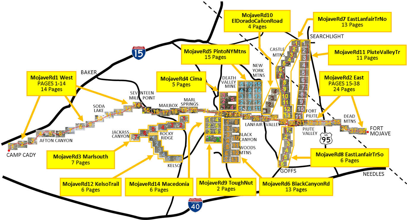
The recreational off-road vehicle industry is expected to climb from a $7 billion industry to an $11 billion industry in the next five years. Maps such as the one in figure 10.5 are a dime a dozen as more and more ORV recreationists cut trails across areas of the Mojave Desert. This map alone includes 114 ORV trails just between I-15 and I-40 outside of Needles, Arizona.
Red Rock Canyon
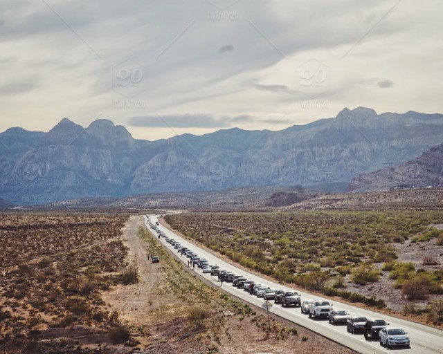
Located only seventeen miles outside of Las Vegas, Nevada, Red Rock Canyon is easy to access, and once inside the conservation area a single one-way loop winds through breathtaking geologic formations.
This popular tourist destination is often packed with cars, so much so that traffic backups in the park can extend for several miles (figure10.6). Approximately two million people visit Red Rock Canyon annually, and most are limited to the one-way loop. Some, however, enter by bicycle or aim for a parking area for backcountry hiking or rock climbing.
Death Valley National Park
A visit to Death Valley may be considered a badge of honor, whether to see spring wildflowers, if winter storms produced enough precipitation, or to muddle through the sweltering temperatures of late spring through fall. This national park, which is located more than 120 miles from any sizable city, sees approximately one million visitors annually, and with them have come invasive species and air quality issues. Particulate matter from the Los Angeles metro area is carried by wind to settle in the lower-elevation valley of the park. This is exacerbated by the dust particulate matter produced by vehicular traffic and by the continued loss of vegetation or changes in vegetative communities that reduce soil stability, making it more susceptible to wind erosion.
Lake Mead National Recreation Area (LMNRA)
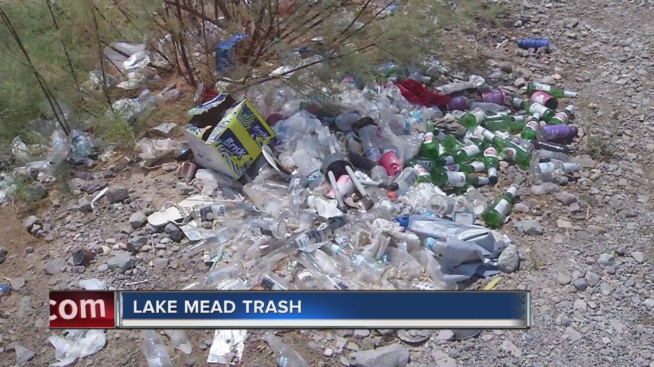
Seven to eight million people visit Lake Mead annually, many of whom boat on the 290 square miles of water. As a result, quagga mussels (Dreissena bugensis) have been established and proliferate in both Lake Mead and Lake Mohave. Not only has an invasive species become firmly established in the lakes, but fountain grass (Pennisetum setaceum) has been established on the land. As visitors to LMNRA increase, so too does the area’s litter problem. The Park Service is so overwhelmed with the volume of litter that in the last decade it developed several programs to address the issue (i.e., prisoner cleanup and adopt-a-cove programs). Although the programs are proving successful to some degree, the issue persists.
Mineral Extraction and Energy Production
Mineral Extraction
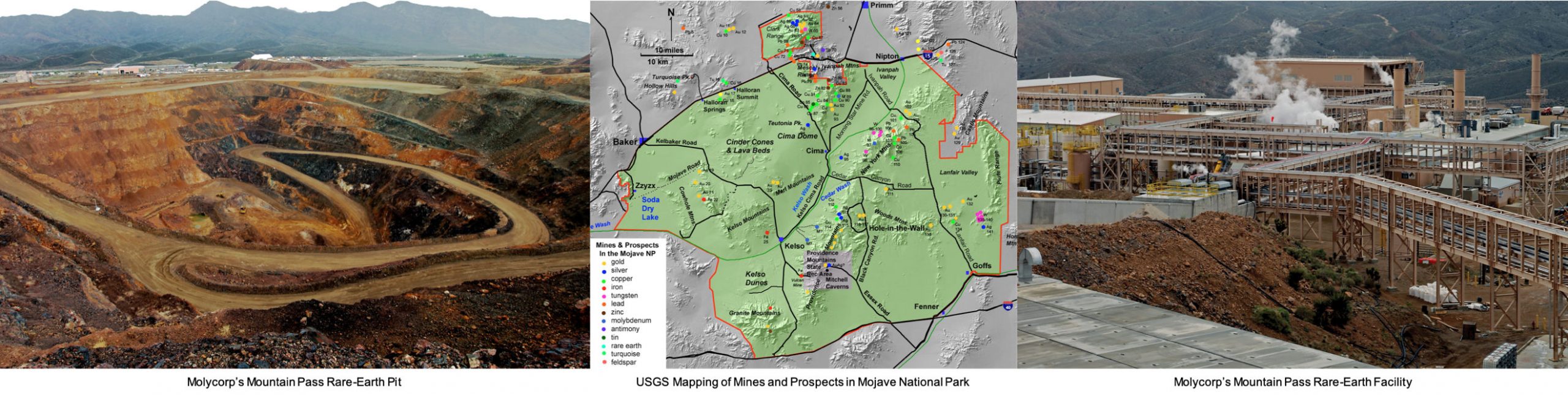
The Mojave Desert has a long history of mineral extraction dating back to the mid-1850s. A truly remarkable amount and variety of minerals have been removed from the area, including gold, silver, lead, zinc, copper, tungsten, vanadium, iron, clay, and cinders. Discovery, exploration, and development of the area’s rich mineral potential was facilitated by the lack of vegetation, which tended to obscure mineral deposits in more temperate locations. Molycorp is one of the largest mineral extraction companies in the Mojave Desert.
Energy Production
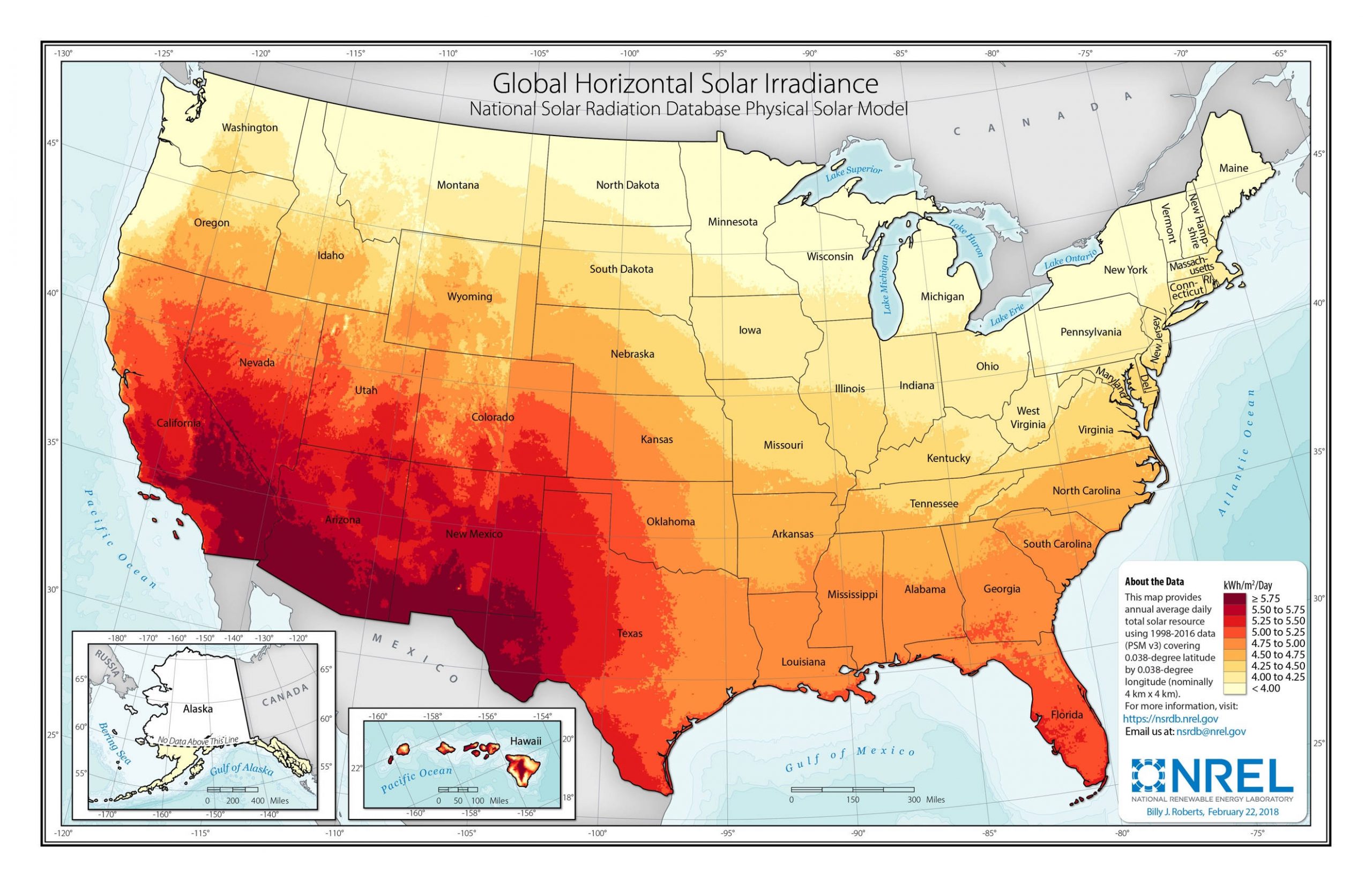
The vast open spaces of the Mojave Desert support large alternative energy installations. Looking at the map in figure 10.10, it’s clear that the latitude and climate of the Mojave Desert make it an ideal location for industrial solar-array complexes. The Mojave Desert, as of 2014, was the location of the largest capacity of solar power in the world, with the combined power of the SEGS (Solar Energy Generating Systems) comprising nine solar power plants and the Ivanpah Solar Power Facility. Newer, larger-capacity plants have recently come online and more will in the near future as part of California’s attempt to obtain 100 percent of its electricity from carbon-zero sources.
Urbanization
Approximately fifteen million people inhabit the Mojave Desert, and population growth continues at around a rate of 3 to 5 percent annually. Growth is concentrated in the western regions near Palmdale and the desert suburbs of the Los Angeles metropolitan area and the Las Vegas Region. Urban centers are increasingly surrounded by planned communities with amenities that insulate inhabitants from the desert aridity. Most people in the Mojave Desert are linked by highways, utility corridors, railroads, and the goods required for life and living are imported by aqueducts, powerlines, pipelines, and commercial transport vehicles (i.e., trains and trucks).
Overall Ecological Impacts of Land Use in the Mojave Desert
Ecological impacts are similar, although they vary in intensity and impact, across Mojave Desert land uses. For all the land uses in the Mojave Desert, a project lead by the Nature Conservancy to identify conservation targets found that large swaths of the desert reflected high landscape integrity to support conservation (figure 10.12).
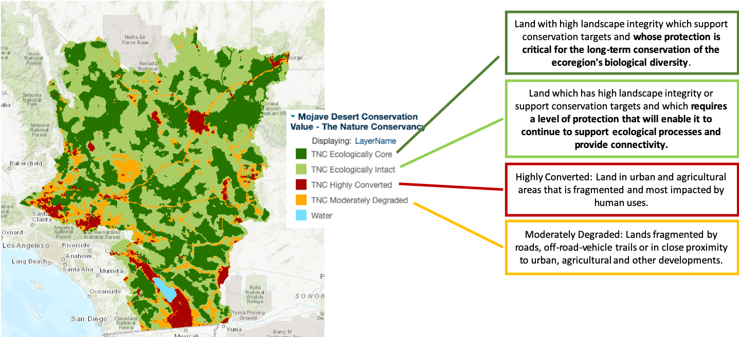
This does not mean, however, that the Mojave Desert does not experience ecological impacts or that those impacts are limited to the red- and orange-shaded areas. Ecological impacts can vary in scale from microsites to local landscapes to large regional areas. Likely the most pervasive and persistent impacts include, but are not limited to, habitat alternation, invasive species proliferation and fire regime shifts, loss of biotic crusts, and reduced soil stability.
Habitat Alteration
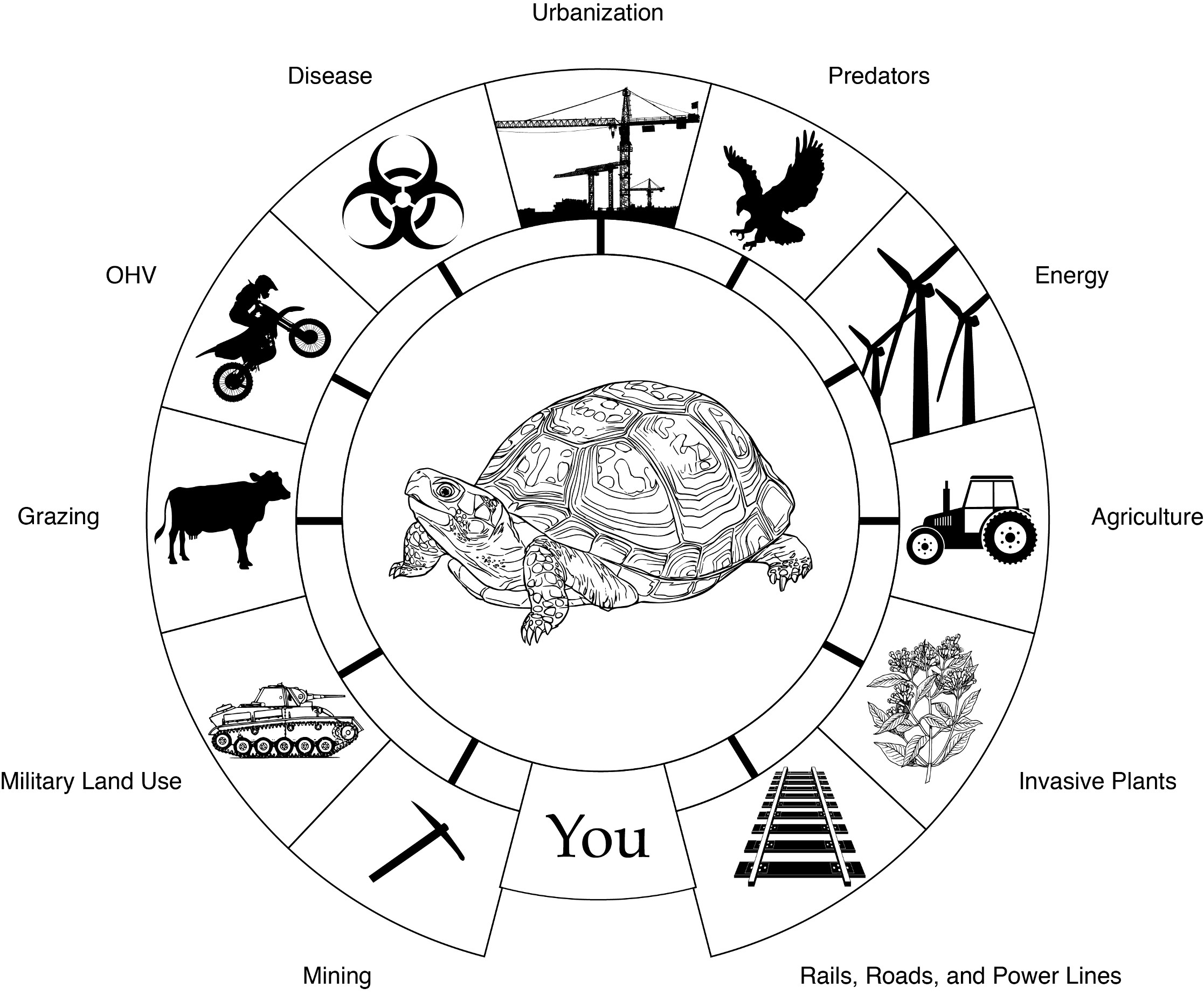
Recall that approximately one-third of the species in the Mojave Desert are endemic, so they likely have specific habitat requirements and fairly restricted ranges. Roads, infrastructure, alternative energy installations, heavily used recreation areas all fragment habitat. The desert tortoise (Gopherus agassizii) is a species whose habitat has been greatly impacted by land uses throughout the Mojave Desert region, particularly by vehicular traffic on-road and off-road.
Tortoises move slowly across the landscape, and they often become casualties when run over. Surprisingly, trash from ORV mini-villages accounts for a fair number of tortoise deaths, as the tortoise mistakes brightly colored trash, such as small plastics, balloons, and bags, for flowers (food); because they are unable to digest trash it remains in their digestive system until they are ill and starving. Trash also attracts and supports higher than normal raven populations, a species that predates juvenile tortoises.
Invasive Species Proliferation and Fire Regime Shifts
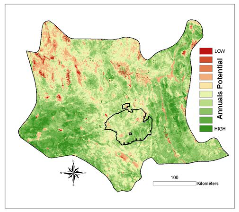
The National Park System leverages a citizen science approach to monitor for fifty invasive species. As with most ecosystems in the western United States, annual species, particularly bromes, are the most serious threat. In 2008 researchers (Wallace and Thomas 2008) mapped the potential of annual invasions throughout the Mojave Desert (green areas are high); not only is the overall potential of invasion high, but areas of greatest risk for invasion correlate to urban and tourist concentrations are as well (figure 10.13). Due to increased densities of brome species, particularly red brome (Bromus rubens), and intensifying land use, the fire regime in the Mojave Desert is becoming more frequent and increasing in severity. Desert plant species are not fire dependent like adjacent chaparral communities to the west. In fact, desert postfire recovery is a long process, particularly for the shrubs that dominate this desert system, which can take up to fifty years to reestablish. Postfire soils are highly susceptible to wind erosion and form physical crusts in the arid conditions of the desert that further challenge the system’s ability to recover.
Saltcedar (Tamarix chinensis) is another invasive species exacerbating the fire regime, altering hydrology, and increasing water and soil salinity. Saltcedar establishes and invades riparian areas, outcompeting native cottonwoods and willows. The species, reproducing vegetatively, grows in dense thickets, altering the flood regimes that native species require and extracting large quantities of scarce water while depositing large quantities of salt into the soil. Saltcedar is highly flammable, but its ability to reproduce vegetatively allows it to quickly reestablish postfire.
Loss of Biotic Crust and Reduced Soil Stability
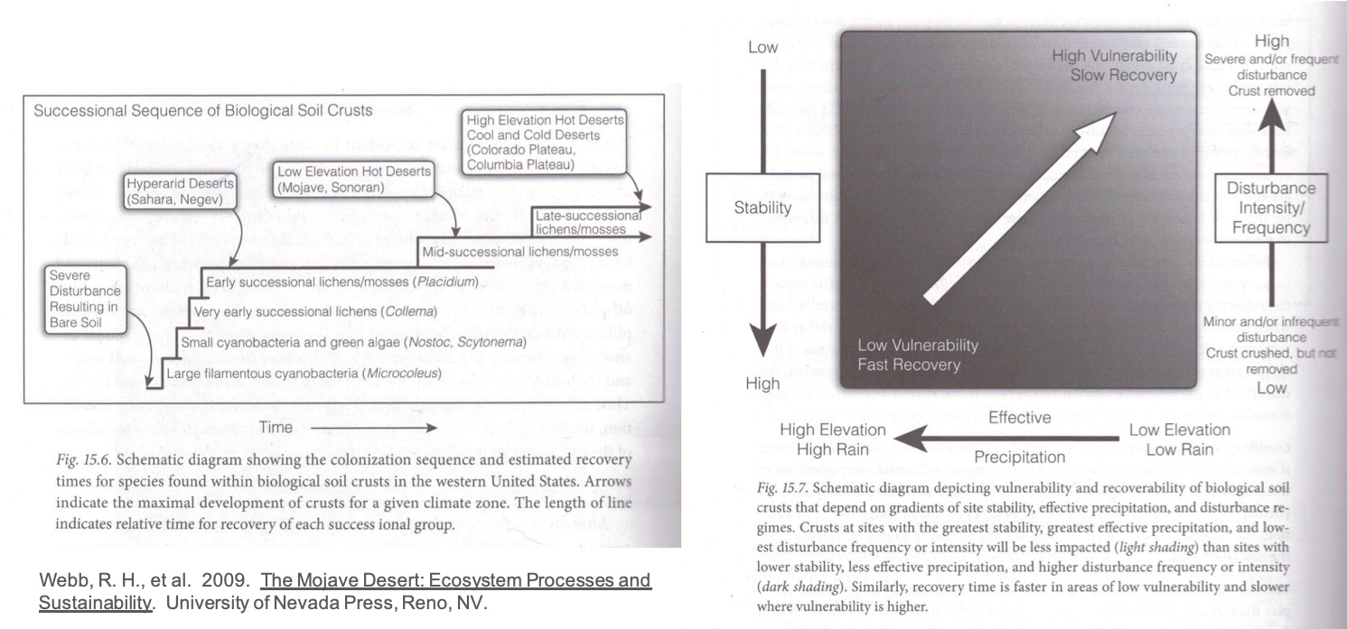
Biotic crusts in desert ecosystems serve a critical role in stabilizing soil, particularly given the strong winds that blow across the region; the crusts also facilitate water infiltration and provide a source of nitrogen in desert ecosystems. In the late successional stages of biotic crust, lichens and mosses establish that provide the level of soil stability and fertility required to support diverse native plant communities. Disturbance by fire, plant invasion, or recreational activities (ORV, hiking, etc.) reduces biotic crust cover, which in turn reduces the fertility of the system and its ability to maintain soil resources.
Recovery and establishment of biotic crust to support diverse communities post-disturbance takes decades and is dependent on elevation, climate, and soil chemistry (figure 10.15). Organisms of biotic crusts are only metabolically active when moisture is available due to precipitation and air temperature conditions. Temperature is important in allowing biotic crust organisms to take advantage of a precipitation event: evaporation rates need to be low at the time of the event. Fine-textured soils have great water-holding capacity and facilitate rooting better than coarse-textured soils, making biotic crust recovery faster. Higher levels of salinity, phosphorus, and manganese also contribute to faster recovery rates.
Restoration and Conservation Efforts
In one of the benefits of being an iconic western landscape, a great deal of focus and energy is being put into mitigation and restoration efforts in the Mojave Desert. As noted above, citizen science is leveraged to monitor invasive plants. Federal agencies, land conservation NGOs (e.g., the Nature Conservancy, Center for Biological Diversity, etc.), and scientists are working together to balance the land-use pressures and preserve the Mojave Desert ecosystem. Much of the restoration effort focuses on native seed programs (e.g., “Right Seed, Right Place”). These programs are critically important as soil seedbanks are depleted in many areas due to wind erosion and establishment of prolific seeding by annual invasive plant species. The “Right Seed, Right Place” aims not only to seed native species but also to do so strategically, so that seeded species and microclimate align for the greatest chance of success.
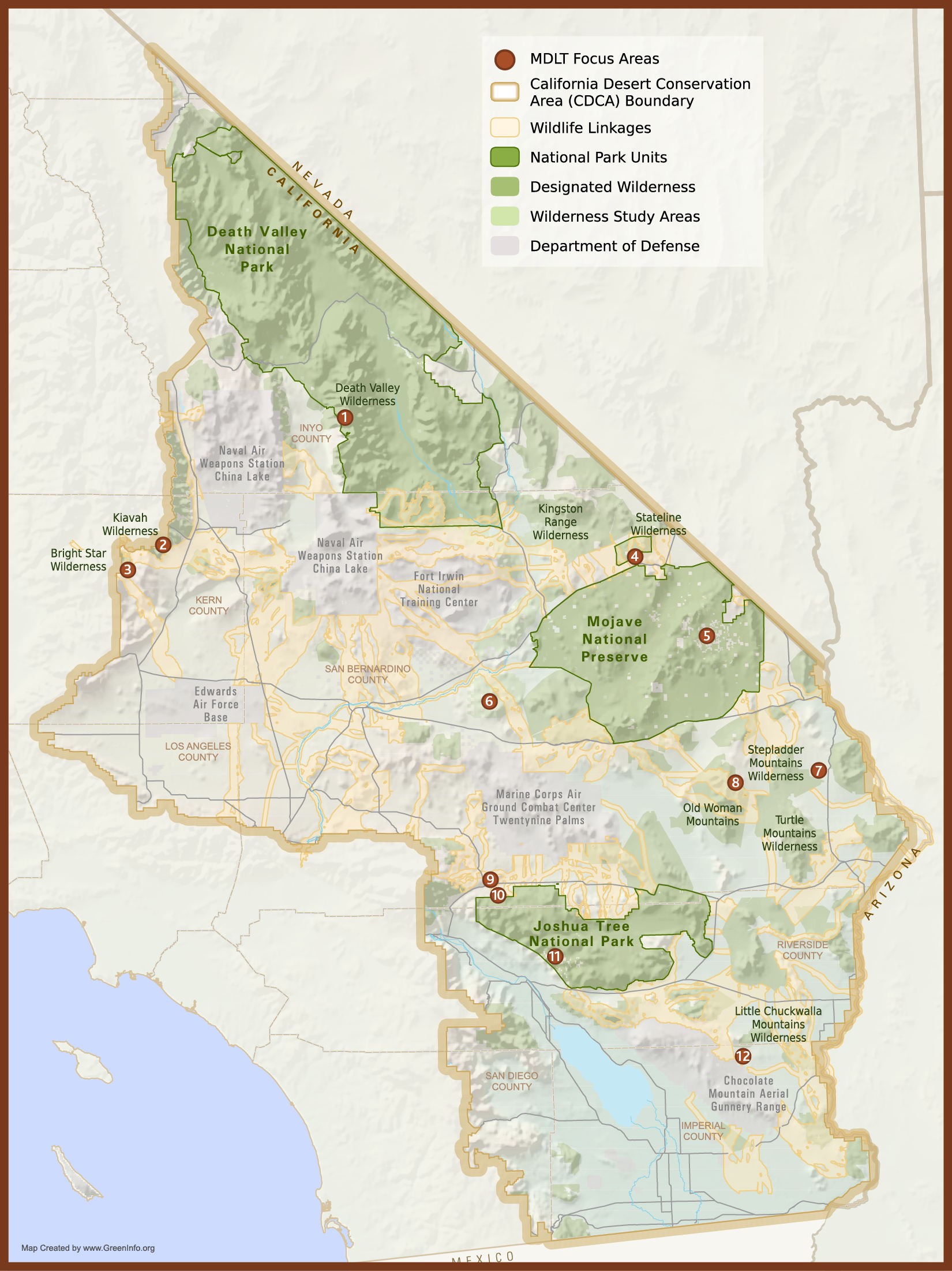
Guided by the Nature Conservancy’s conservation target mapping (figure 10.11 above), the Mojave Desert Land Trust is working tirelessly to place biologically sensitive and culturally important areas under more stringent conservation restrictions (figure 10.15). Part of their efforts in this pursuit is land acquisition and trade with private landowners and federal land management agencies.
The Center for Biological Diversity (CBD) supports numerous ongoing projects to support desert tortoise protection and habitat restoration. CBD also focuses on the Mojave River and riparian areas, which provide habitat to six species of endangered fish.
Wildlife Defenders are leading efforts to protect bighorn sheep habitat and migration corridors at higher elevations.
