Unit 3: Considering the Influence of Light and Thermal Phenomena on Local Weather
VI. Using Mathematical Representations to Estimate a Quantity of Interest
In our area, going to the beach involves being aware of and prepared for the possibility of a tsunami occurring. A tsunami is a large wall of water that may flood a beach and surrounding areas because of an earthquake. Geologists have used mathematics and knowledge of physical phenomena to build complex computer models for predicting earthquakes and tsunamis.
A. Exploring computer models designed to predict earthquakes and tsunamis
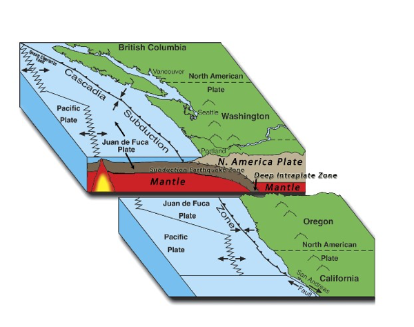
A major 9.0 earthquake may occur, for example, off the coast of northern California, Oregon, Washington and British Columbia. This region is called the Cascadia Subduction Zone (see http://www.oregon.gov/oem/hazardsprep/Pages/Cascadia-Subduction-Zone.aspx ). This fault line is about 600 miles long and lies under the Pacific Ocean about 70 to 100 miles beyond the shoreline. If there is a major earthquake along this fault line, a tsunami wave that comes ashore is predicted to be up to 100 feet high.
Question 3.11 How do geologists predict earthquakes and tsunamis?
The Earth’s surface is broken up into tectonic plates, (https://www.geolsoc.org.uk/Plate-Tectonics/Chap2-What-is-a-Plate ). A subduction zone is a region in which one plate moves underneath another. The cause of multiple earthquakes in the Pacific Northwest region is attributed to movement of the Juan de Fuca oceanic plate under the North American plate as shown in Fig. 3.23.
http://www.oregon.gov/oem/hazardsprep/Pages/Cascadia-Subduction-Zone.aspx
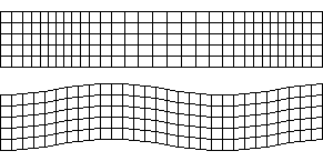
When one tectonic plate presses against another, pressure builds up until motion occurs; the earthquake releases energy that travels outward through the Earth as seismic waves (http://www.geo.mtu.edu/UPSeis/waves.html ). The primary waves, known as p-waves, are compression waves that travel quickly through the Earth as shown in Fig. 3.24. P-waves move the earth back and forth in the direction of motion. Secondary waves, known as s-waves, are like water waves, they move the earth up and down, or side to side, as shown in Fig. 3.24. https://en.wikibooks.org/wiki/Historical_Geology/Seismic_waves
- For each pair of students to model what happens during an earthquake: Use a Slinky® .
- To model p- waves, each pair holds the end of a Slinky® with the Slinky® stretched out along the floor. One gives the Slinky® a hard push toward the other.
- Next model s-waves. One person gives the Slinky® a quick jerk side to side. If the pair are standing up, jerk the Slinky® up and down.
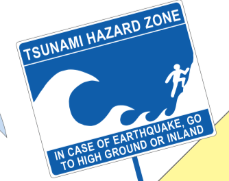
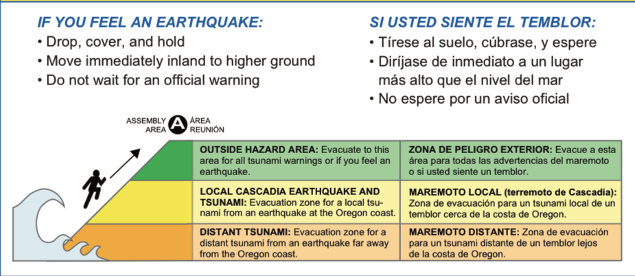
If such an earthquake happens off the Pacific Northwest coast, a series of large ocean waves, up to 100 feet high, may quickly flood coastal areas in 15 to 20 minutes (see: http://www.oregongeology.org/tsuclearinghouse/ ). These huge waves are called tsunamis. Tsunamis might also originate in distant earthquakes occurring under the ocean elsewhere, with perhaps several hours warning. Signs in tsunami zones alert residents and visitors with a visual display of the danger as shown in Fig. 3.25.
Residents of these areas and visitors to the beaches and coastal towns need to be aware of where high ground is and how to get there. For links to evacuation maps for many Oregon locations see, for example: http://www.oregongeology.org/tsuclearinghouse/pubs-evacbro.htm . Details are available at http://www.oregongeology.org/pubs/fs/TIM-maps-factsheet.pdf. Before leaving home, visitors should locate where they will be and review evacuation routes and what to do in case of a tsunami (see http://nvs.nanoos.org/TsunamiEvac and Fig. 3.26 and Fig. 3.27.)
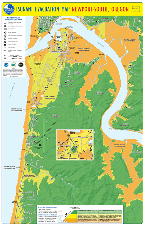
The instructions at the top of the map state:
https://www.oregongeology.org/pubs/tsubrochures/NewportSouthEvacBrochure-12-12-12_onscreen.pdf
The predicted safe areas are green, the areas likely to be inundated by a local tsunami are yellow, and those likely to be inundated not only by a local tsunami but also by a distant tsunami from an earthquake far away from the Oregon coast are orange. An A on the green area of the map indicates a designated assembly area in the event of an evacuation.
Steps to be prepared include making a disaster plan, preparing supplies in case of a disaster, protecting yourself during an earthquake, evacuating if necessary, and following your plan (see: http://www.oregongeology.org/tsuclearinghouse/steps-visitors.htm#prepare ). Although an enticing very low shore may occur just before and after a large wave, it is important to head immediately away from the beach as more very large waves may follow.
Preparation includes assembling a ‘Go-Bag’ to keep in your car in case of a disaster (see, for example, the suggested list for a 3-day emergency kit at the end of https://www.oregongeology.org/pubs/tsubrochures/SeasideGearhartEvacBrochure-6-3-13_onscreen.pdf or https://www.redcross.org/get-help/how-to-prepare-for-emergencies/survival-kit-supplies.html . Suggested items include water (1 gallon per person per day), 3-day supply of non-perishable food, first aid kit, non-prescription drugs, tools and supplies, sanitation items, entertainment (games, books), clothing and bedding, special requirements, and copies of important family documents.
1. Examples of student reflections upon discussing earthquake and tsunami preparedness with a friend or family member
A guest, Douglas Lownsbery, facilitated a class session in which he provided information and set up four centers about earthquakes and tsunamis: a set of items for students to choose within 10 seconds which they would put in a “go bag,” a large plastic container with sand, water, and toy people and houses with which to model a tsunami occurring, a long slinky® to model p- and s-waves, and a core sample that he had prepared with 5th graders at a local beach, that included evidence of a previous tsunami in our area. After the session, the students wrote about their experiences discussing earthquake and tsunami preparation with a friend or family member. A student provided the reference for an article and a reflection on a conversation with a roommate. The article was a follow-up to an earlier article about the expected major earthquake in the Pacific Northwest, The Really Big One by Kathryn Schulz in The New Yorker, July 13, 2015 issue (https://www.newyorker.com/magazine/2015/07/20/the-really-big-one ).
The New Yorker Magazine, How to Stay Safe When the Big One Comes https://www.newyorker.com/tech/annals-of-technology/how-to-stay-safe-when-the-big-one-comes
My “learner” this week was one of my roommates. I had her read over the article that I had chosen from the New Yorker and we had quite a big discussion about it. We talked about how we and no one we know bolt things down in our homes for safety. We also do not have a kit to be prepared for a tsunami or an earthquake.
After talking about the article, I started talking about how we should all have “go bags.” Many of us do not think that this would affect us, but it could happen at any time we are near the coast and it is best to be prepared to help yourself and to help others. We were wondering what exactly we SHOULD put in our go bag because that was not extremely clear when we were learning about it in class. The city of Seaside Oregon has a “go bag” section on their website. They recommend that you pack:
- First Aid kit,
- prescriptions and non-prescription medication
- Water bottle and treatment supplies capable of providing 1 gallon per person per day
- Non-perishable food
- Cooking and eating utensils, can opener, cook stove.
- Waterproof matches, lighter or flint
- Shelter (tent, tarp or poncho)
- Emergency blanket
- Portable NOAA weather radio
- Flashlight or headlamp, and extra batteries
- Warm clothing
- Personal hygiene items (toilet paper, soap, toothbrush)
- Tools and supplies (pocket knife, shut-off wrench, duct tape, gloves, whistle, plastic bags)
- Cash
This did not include things like rope or an emergency blanket, but a “go bag” can be different for everybody. The important part is that we always have one in our car.
We talked a lot about cause and effect. When an earthquake hits-what do we do? What happens next? When can you tell a tsunami is about to hit? Where should you go when it is hitting? What happens to houses and people that are not in the safe zone? What does a town look like after a tsunami hits? How far away from the coast can a tsunami travel?
The cause: the earthquake/tsunami
The effect: how it effects people and towns
In doing this we used the science and engineering practice of asking questions and defining problems. This was an easy one to cover because we do not know much about tsunamis and earthquakes because this area does not seem to be worried about them even though we should be.
Another student talked with a family member who lives in a tsunami evacuation zone
I decided to engage my mom in learning about earthquakes and tsunamis. I chose to talk to her about this topic because she lives on the coast and will directly be impacted by the earthquake and tsunami that are due to occur anytime soon. I have noticed that many people are aware of the fact that Oregon is expecting a natural disaster in the near future but no one has done anything to prepare for this.
I first began by asking my mom what she knew about earthquakes and what she has done so far to prepare for an earthquake and tsunami. She knew a lot of facts about earthquakes along with understanding the scientific reasoning for why tsunamis happen but unfortunately she has not done anything to prepare.
I took this time to pull up the elevation map that was shown in class to show the best places to run to during a tsunami. While looking at this map we both realized that our house is in a zone that is expected to be under water in the event of a tsunami.
“I am not even sure what I would put in a go bag if I needed to make one.” stated my mother. I took this opportunity to talk to her about the activity we did in class where we had 10 seconds to pack 10 items in a bag. I told her about some of the items I put in the bag and why I put these things in. She asked what types of food would be best to start stocking up on.
I told my mom the story about the little girl named Tilly that saved not only her family but also other people while on vacation in Thailand. Since my mom is a fourth grade teacher I told her the importance of talking about this topic with her students. She understood and agreed with me and said she wants to start talking about earthquakes and tsunamis more in her classroom.
…We also talked about evacuation routes, plans, and communication. My mom made the decision to continue this investigation by researching different ways to educate her students on the importance of being prepared during this type of event. The crosscutting concept that we used during this discussion was cause and effect. We talked about earthquakes and tsunamis and the impact it would have on our family physically, mentally, and emotionally.
An emphasis on how to prepare helps to mitigate the fear that one may experience in realizing what might happen should a major earthquake occur.
B. Exploring computer models designed to predict the weather
Computers also can make weather predictions based on complex mathematical models. Many of these are developed by government agencies and are available for public use on the Internet.
Question 3.12 How do meteorologists predict the weather?
Meteorologists use mathematics to build complex computer models that they use to predict the weather. See an example provided by the National Oceanic and Atmospheric Administration’s Weather Prediction Center at http://www.wpc.ncep.noaa.gov/ Also put in http://www.weather.gov and enter a zip code for a local prediction.
