5 Earthquakes in the Juan de Fuca Plate
Tower: Horizon 177, [this is] Seattle Tower, you’re No. 2 following a heavy Boeing 767, short final. Wind 130 at 8. Runway 16 Right. Cleared to land. (Pause). All right, we’ve got an earthquake. Everybody hold on, folks. (Pause). Attention all aircraft in Seattle. We have a huge earthquake going on. The tower is collapsing. I say again. The tower is falling apart. Hang on everybody. (Pause) OK, we got a huge earthquake going on in Seattle. Everybody be careful out there, all right?
Pilot: American 27 heavy, we’re about to turn final.
Tower: All right, everybody on Seattle Tower, I want you to use extreme caution. The tower windows have collapsed here. Asiana 272 heavy, turn left here, hold short on 16 Left, remain on this frequency. And Horizon 301, I want you to turn left, and I want you to go to the ramp, and remain on this frequency. All the windows are gone from the tower but two.
Pilot: This is 301, we’re turning off here at—
Tower: All right, I want everyone to pay attention here, because I don’t know what’s working and what’s not. All the windows are gone.
Sea-Tac tower operator Brian Schimpf during the 2001 Nisqually Earthquake
1. Commotion in the Ocean
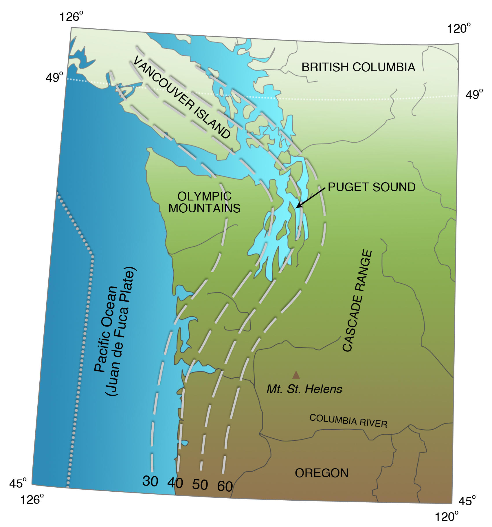
The Juan de Fuca Plate is entirely oceanic (Figures 2-7), with thin crust made up of basalt. No part of it is above sea level. The crust is nowhere more than a few tens of millions of years old, which means that it is relatively shallow, weak, and hot. Its weakness means that it is subject to internal deformation where it interacts with the continental edge of North America. At its northern and southern ends, where the spreading center is closest to the base of the continent, and the oceanic crust is youngest, the weak oceanic plate is being actively deformed internally, deformation that is marked by frequent earthquakes (Figure 4-14). These seismically active regions are generally referred to as separate plates, the Explorer Plate off Vancouver Island and the Gorda Plate off northern California (Figure 5-1). The Juan de Fuca Plate between its northern and southern ends has few earthquakes, indicating that internal deformation is less important there.
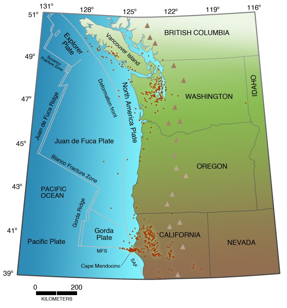
The fact that the Juan de Fuca Plate is completely oceanic means that we are not able to measure its displacement rates directly but instead must rely on indirect geophysical evidence. All permanent seismic stations are onshore, resulting in considerable inaccuracy in locating earthquakes on the plate. However, in recent years, the declassification of the U.S. Navy’s hydrophone detection system has allowed scientists of the National Oceanic and Atmospheric Administration (NOAA) in Newport, Oregon, to study earthquakes using seismic waves (T-phase waves) that are transmitted through ocean water rather than through the crust beneath the ocean. They have been able to improve greatly the accuracy and detection threshold for earthquakes far from shore (Figure 4-14).
Mapping of the distribution of earthquakes shows that the spreading centers, the Juan de Fuca, Gorda, and Explorer ridges, generate low-level seismicity related to the movement of magma that rises to the surface and forms new oceanic crust. These earthquakes are small, most of them too small to be detected by ordinary seismographs onshore, although they are monitored through the SOSUS hydrophone detection system.
On the other hand, the Gorda Plate is cut by large strike-slip faults that rupture frequently to cause earthquakes (Figures 2-4, 5-2). The Gorda Plate west of Arcata, California, sustained an earthquake of M 7.3-7.6 on January 31, 1922, that was felt in Oregon and Nevada, and as far south as San Jose, California. Another earthquake of M 6.9-7.4 thirty miles west of Trinidad, California, on November 8, 1980, destroyed a bridge, liquefied the sand bar at Big Lagoon, and caused six injuries and $1.75 million in damage. In 1991, the Gorda Plate was shaken by an earthquake of M 6.9 on July 12, another of M 6.3 on August 16, and the largest one of M 7.1 on August 17, three hours after a crustal earthquake onshore. On April 26, 1992, one day after the M 7.1 Cape Mendocino Earthquake on the Cascadia Subduction Zone, two aftershocks of M 6.0 and M 6.5 struck the Gorda Plate twelve and eight miles, respectively, offshore. One of these aftershocks trashed the commercial district of the small town of Scotia. These were the largest of hundreds of aftershocks of the Cape Mendocino earthquake in the Gorda Plate, complicating the problem of whether that earthquake was mainly a subduction-zone earthquake or a Gorda Plate earthquake. Except for the 1980 earthquake and the two Petrolia aftershocks, these Gorda Plate earthquakes were far enough offshore that intensities on the coast did not exceed V or VI.
The Gorda Plate has accounted for more damaging historical earthquakes in northern California than any other source, including the Cascadia Subduction Zone and the North American Plate. However, it is incapable of producing earthquakes in the M 8 to 9 range, such as those expected on the Cascadia Subduction Zone.
The Explorer Plate off Vancouver Island is also shaken by frequent earthquakes (see Appendix A). But, unlike Gorda Plate earthquakes, these are far enough from populated areas that they do no damage and in some cases are not even felt onshore.
2. Offshore Transform Faults:
The Northwest’s Answer to the San Andreas Fault
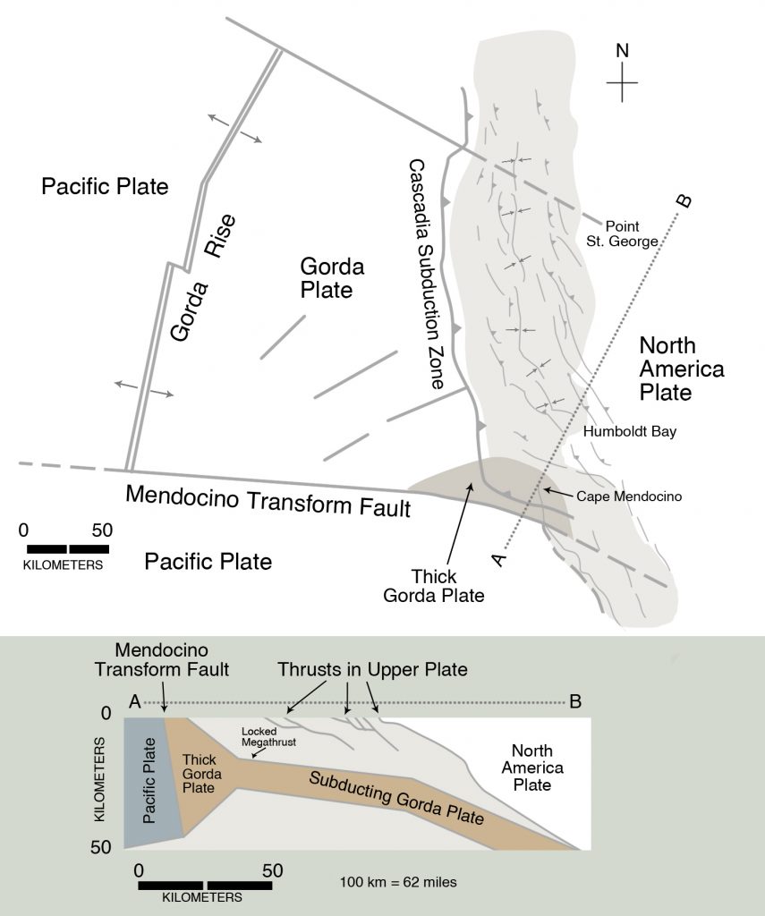
In Chapter 2, we considered two types of plate boundaries: ocean ridges or spreading centers, where new oceanic lithosphere is created as plates move away from each other, and subduction zones, where oceanic lithosphere is recycled back into the interior of the Earth as plates move toward each other. The Juan de Fuca and Gorda ridges are examples of spreading centers, and the Cascadia Subduction Zone is an example of two plates converging (Figures 2-6 and 5-1). We also considered a third type of plate boundary where plates neither converge nor diverge but instead move past each other without destroying or creating lithosphere. These are called transform faults because they transform plate motion between two spreading centers. They involve the entire lithosphere and not just the Earth’s upper crust.
The San Andreas Fault is a transform fault in which continental rocks of the North America Plate move past continental rocks of the Pacific Plate (Figure 2-8, top diagram, and animation, Figure 2-9). Transform faults in the Pacific Northwest, on the other hand, are found on the deep ocean floor, where they form linear topographic features called fracture zones. The Blanco Fracture Zone separates the Juan de Fuca and the Gorda ridges, and the Sovanco Fracture Zone separates the Juan de Fuca and the Pacific plates (Figure 5-1). The Mendocino Fracture Zone separates the Gorda and Pacific plates and is the northwest continuation of the San Andreas Fault. These are typical transform faults. The grinding of one plate past the other causes many earthquakes on these fracture zones. Barring the next subduction-zone earthquake, they and the interiors of the Gorda and Explorer plates have the highest instrumental seismicity in the Pacific Northwest, onshore or offshore. Large earthquakes on the Mendocino and Blanco fracture zones are felt frequently every year in northern California and southern Oregon.
At first glance, the Blanco Fracture Zone resembles a left-lateral strike-slip fault because of the apparent left offset of the Juan de Fuca and the Gorda ridges (Figure 5-1). But this apparent left offset would only be true if these ridges had once been a continuous unbroken ridge that was later separated along the Blanco Fracture Zone. This is not the case. Remember that the Juan de Fuca Plate is moving away from the Pacific Plate at these spreading centers. Imagine yourself standing on the Pacific Plate looking northward across the Blanco Fracture Zone at the Juan de Fuca Plate. The Juan de Fuca Plate moves from left to right along the Blanco Fracture Zone with respect to your position on the Pacific Plate. This means that the transform fault on the Blanco Fracture Zone is a right-lateral, not a left-lateral, fault.
As another thought experiment, imagine two jigsaw puzzle pieces that lock together by a tab that projects from one piece into the other. Now pull the pieces slowly apart. They are difficult to separate because the sides of the tab resist being pulled apart. In the same way, the Pacific and Juan de Fuca plates are being pulled apart, with molten rock welling up along the spreading centers as the plates are separated. Along the Blanco Transform Fault, the crustal plates push past each other, generating friction and producing earthquakes. These earthquakes could be as large as magnitude 7 or even larger, but probably not 8. The crust is too warm and therefore too weak to generate such large earthquakes. Accordingly, despite the high instrumental seismicity on the Blanco Transform Fault, including many earthquakes felt onshore, it does not constitute a major hazard to communities along the coast, in part because the earthquakes are many miles offshore, and in part because these offshore earthquakes are not large enough.
Earthquakes on the Mendocino Transform Fault are frequent. The first recorded major earthquake was felt on May 9, 1878, causing chimneys to fall in Petrolia, California, at the Triple Junction (Appendix A). A larger earthquake, of M 6.5-7.3, struck close to Cape Mendocino on January 22, 1923, resulting in intensities of VIII and damage to buildings in Petrolia. Other earthquakes include a magnitude 6 in 1922 and smaller earthquakes in 1932, 1936, and 1951. Other earthquakes with magnitudes greater than 6 struck in 1954, 1960, and 1984. The 1984 earthquake of M 6.6, 166 miles west of the coast, was felt from Oregon to San Francisco, but it produced intensities of V or less because of its great distance from shore. On September 1, 1994, an earthquake of M 6.9-7.2 struck the Mendocino Transform Fault 88 miles offshore, the largest earthquake to strike the United States that year, larger even than the Northridge Earthquake of the preceding January. Because it was so far offshore, it did no damage, but it was felt from southern Oregon to Marin County, California.
Like the Blanco and Mendocino faults, the San Andreas Fault is also a transform fault, separating the Gorda Rise from a spreading center in the Gulf of California of northwest Mexico (Figure 2-8, top diagram; Fig. 2-9 animation). The offshore transform faults differ from the San Andreas in involving relatively hot oceanic crust and mantle, whereas the San Andreas cuts across colder continental crust for most of its length. For this reason, the San Andreas generates significantly larger earthquakes than does the Blanco, up to at least M 7.9. So, fortunately for the Pacific Northwest, the Blanco and Mendocino are the weaker relatives; they generate many earthquakes, but no giant ones.
Two transform faults lie off the coast of Vancouver Island: the Sovanco Fracture Zone that separates the Explorer Plate and the Pacific Plate, and the Nootka Fracture Zone that separates the Explorer Plate and the Juan de Fuca Plate (Figures 2-8, 5-1). Like the Blanco, these fracture zones are characterized by high seismicity, but are not believed to generate very large earthquakes. In the next chapter, we will consider the possible relation between the oceanic Nootka Fracture Zone and two large historical earthquakes in continental crust of central Vancouver Island.
Northwest of the Explorer Plate, the Pacific Plate grinds against the North America Plate along the Queen Charlotte Fault, located at the base of the continental slope. On August 22, 1948, this fault was the source of an earthquake of M 8.1, larger than any historical earthquake on the west coast of the United States south of Alaska. On October 27, 2012, this fault was the source of the Haida Gwaii earthquake of M 7.8 (using the First Nations name, Haida Gwaii, for the Queen Charlotte Islands). This fault had a focal mechanism of reverse faulting rather than the expected strike slip. These earthquakes are evidence that the Queen Charlotte Fault poses a hazard to the thinly populated coast of British Columbia north of Vancouver Island, including the Queen Charlotte Islands. However, the region is so thinly populated that it is not considered as a major earthquake threat in Canada.
3. Slab Earthquakes in the Juan de Fuca Plate Beneath the Continent: Puget Sound Region
The greatest amount of seismicity generated by the Juan de Fuca Plate itself (not including the Explorer and the Gorda plates) is beneath western Washington, where it is being subducted beneath North America (Figures 3-21, 5-1). These are called slab earthquakes or Benioff zone earthquakes. Most of the damage and loss of life in the Pacific Northwest has been as a result of these earthquakes, including the largest known historical shocks to strike either Washington or Oregon.
The first of these, on April 13, 1949, really should have been no great surprise. The southwesternmost Puget Sound region had been struck by earthquakes on November 13, 1939 (M 5.5-5.9), and on February 15, 1946 (M 6.3). Both were slab earthquakes, and both had produced intensities as high as VII, which meant minor damage and collapse of chimneys. The 1949 earthquake of M 7.1 struck the southern Puget Sound region just before noon on April 13. Strong shaking lasted about thirty seconds. Most people were at work, getting ready to go to lunch. Most schools were on vacation, which turned out to be a blessing because of the collapse of many unreinforced brick school buildings. The epicenter was between Olympia and Fort Lewis, and the high-intensity damage zone extended from Rainier, Oregon, on the Columbia River, north to Seattle (Figures 5-3 to 5-5). The earthquake was felt from Vancouver, B.C., to Klamath Falls and Roseburg, Oregon. A sidewalk clock outside a jewelry store at 1323 Third Avenue in Seattle stopped at the moment of the earthquake: 11:56.
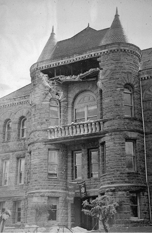
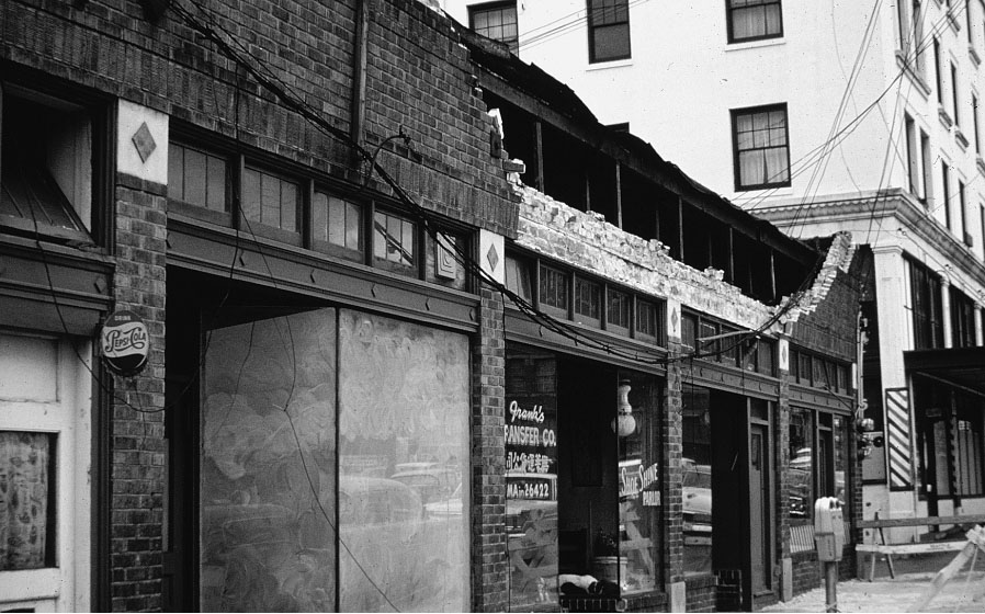
Eleven-year-old Marvin Klegman was killed, and two other children were injured by falling bricks as they played outside the Lowell School in Tacoma. Jack Roller was killed when part of the Castle Rock School building collapsed on him. Five students and two teachers were injured at Adna School 10 miles west of Centralia. One little girl was critically injured as she left her second-grade classroom. Tons of bricks fell from the Lafayette School building in Seattle, but school was not in session, and children were playing in the schoolyard far from the building. The Lafayette School was one of ten Washington schools condemned after the earthquake. The auditorium collapsed at Puyallup High School (Figure 5-3), but no one was in it at the time. Part of the Boys Training School at Chehalis crumpled and fell, injuring two boys.
There were many narrow escapes. Freda Leaf, seventy-one, jumped into the Duwamish River but was rescued by a neighbor, D. V. Heacock. Part of the roof of the Busy Bee Restaurant on Second Avenue in Seattle fell in, and the patrons headed for the exit. The proprietor, George Pappas, immediately saw the danger and ordered the bartender, a big man named Bill Given, to block the exit. Moments later, tons of bricks cascaded onto the sidewalk in front of the restaurant. Water spilled out of an old water tower at the reservoir at Roosevelt Way and East 86th Street; a few minutes before, painters working at the tower had knocked off for lunch. At the Tacoma Narrows Bridge, under repair at the time, a twenty-three-ton steel saddle mounted to hold up a suspension cable dislodged and plunged off the bridge and through a scow on the water below, injuring two people. In Olympia, the Old State Building (Figure 5-4) and the State Insurance Building were the worst hit. Governor Arthur Langlie and his assistant, Dick Everest, were in their offices in Olympia and were showered with falling plaster.

At the Blue Mouse Theater in Tacoma, people were watching the earthquake scene from The Last Days of Pompeii as the earthquake struck. In a bizarre coincidence, a crucifixion scene with accompanying earthquakes was being shown at the time of the earthquake at the nearby Roxy Theater. At Second and Occidental in Seattle, a man was seen walking rapidly down the street after the earthquake clad only in underwear, sports coat, and shoes.
In Oregon, broken water pipes flooded the basements of two stores in Astoria, plaster cracked in Florence, and dishes crashed from their shelves in Newport. Chimneys crashed at Reed College in Portland, and office workers on the twelfth floor of the new Equitable Building were knocked to the floor.
Fortunately, perhaps amazingly, only seven lives were lost, and damage was only $15 million, even though the magnitude was 7.1. In today’s dollars, the losses would be perhaps twenty times that; the losses to Washington schools alone would have been $60 million in 1998 dollars. But losses were still remarkably low. Probably the main reason, aside from school being out of session, was that the focal depth of the earthquake was about thirty-five miles below the surface, meaning that the shock waves had thirty-five miles to weaken in amplitude before reaching the surface. Because it was such a deep earthquake, the Intensity VIII zone was very large, but there were no areas of Intensity IX or X, as there would have been with a shallower crustal earthquake of the same magnitude.
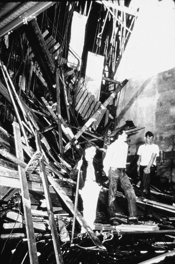
On April 29, 1965, at 8:29 in the morning, a second large slab earthquake with magnitude 6.5 struck between Kent and Des Moines, south of Sea-Tac Airport between Seattle and Tacoma. Like the 1949 earthquake, its focus was more than thirty miles beneath the surface.
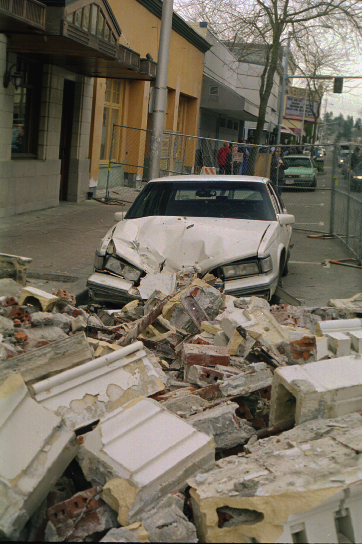
Adolphus Lewis, seventy-five, a retired laborer, was on his way from his hotel room to have breakfast when he was killed by falling debris (Figure 5-6). Raymond Haughton,fifty-two, was killed, and Eugene Gould, fifty, critically injured when a fifty-thousand-gallon wooden water tank on a two-hundred-foot tower collapsed at the Fisher Flouring Mills. In total, six people were killed, including those suffering heart attacks, and property damage was estimated as $12,500,000, $60 million in 1998 dollars.
As in 1949, there was considerable damage to school buildings. In Seattle, parts of Broadview Elementary School collapsed, and there was damage to the Ballard High School auditorium. The greatest damage was to West Alki Elementary School, where a chimney sixty feet high fell into the boiler room, narrowly missing the custodian. Unlike 1949, no pupils were injured.
The 8:15 mass at St. James Cathedral was interrupted when low-hanging chandeliers began to swing violently. Two hundred parishioners fled the cathedral, but returned for the remainder of the service when the tremors subsided. At the Rainier Brewing Company, two thousand-barrel aging tanks were knocked off their platforms. One split open, spilling enough beer for fifteen thousand cases. Engineer John Strey found himself wading hip deep through the foamy beer. The restaurant at the top of the Space Needle was full of customers when it began to sway, “like riding the top of a flagpole.” No one ran for the elevators, and all finished breakfast after the violent shaking had ceased.
The next earthquake arrived thirty-four years later at 6:44 p.m. July 2, 1999, at Satsop, Washington, ironically the site of a nuclear power plant proposed by the Washington Public Power Supply System that, fortunately, never got built. The earthquake had a moment magnitude of 5.8 and was twenty-five miles deep. The lovely old Grays Harbor County Courthouse in Montesano, built in 1910, was severely damaged. The ceiling and an exterior wall of Moore’s Furniture Store in Aberdeen collapsed, causing extensive havoc inside. Chimneys toppled, gas lines leaked, and power went out throughout much of Grays Harbor County. John Hughes of The Daily World in Aberdeen reported from the parking lot on State Street that “(s)treetlight poles shook, my Volkswagen Beetle did the Macarena while Dee Anne Shaw’s Chrysler coupe was undulating.”
Then came 11:54 a.m. on Ash Wednesday, February 28, 2001.
I was having a late-morning cup of coffee in Corvallis when I began to feel dizzy. The two people across the table from me continued to talk and obviously felt nothing, so I thought I was ill. Then I saw the swaying of a lamp and realized that I was feeling the long-period waves from a distant earthquake.
Brian Wood of KIRO-TV was setting up for a press conference by Seattle Mayor Paul Schell, who was about to explain the city’s response to the Mardi Gras riots the previous night in which one person had been killed. Before the mayor arrived, the room began to shake, and Wood immediately began to broadcast: “This is Brian Wood, live in downtown Seattle, live on the twelfth floor of the mayor’s conference room. We were waiting for a news conference when it hit, an earthquake.” This made KIRO first with the story, which was broadcast nationwide. Later, ABC in New York would ask sheepishly if it could carry the story from KIRO, a CBS affiliate, because its ABC affiliate, KOMO-TV, had taken too much time getting organized.
Curtis Johnny and his girlfriend, Darlene Saxby, headed for the exit of their South Park apartment as soon as they felt the earthquake. Suddenly, a chimney crashed through the ceiling, covering Johnny with bricks. “I was pretty hysterical,” Darlene said. “I was just throwing bricks off of him and screaming at the same time.” Neighbors had to break in the door to the apartment to get them out. Hin Pang and his wife Sim Pang were visiting friends at a Chinatown club when the earthquake hit. As they ran from the building, they were struck by a shower of bricks from a ledge three stories above them. Sim Pang suffered head, chest, and arm injuries but was released from Harborview Medical Center later in the day. She had been buried by the bricks, and she suffered chest injuries and a crushed pelvis; he remained in the hospital for a longer time but survived.
Old buildings fared the worst. Tops of brick buildings crashed to the street along Alaskan Way Viaduct and along Second Avenue, crushing cars. A huge piece of the Fenix Undergound, a night club on Second Avenue South, fell on two parked cars; the inside wall collapsed, trapping club owner Mike Lagervall and his secretary inside. The roof of the Washington Federal Savings building partially fell in, and one of its façades covered a ninety-foot stretch of sidewalk (Figure 5-7). The Compass Center, a facility for eighty homeless men in Pioneer Square, had to be abandoned. The Alaskan Way Viaduct itself, built in 1953 for $8 million, suffered damage but did not collapse; replacing it would cost $400 million. (A few years later the Alaskan Way viaduct would in fact be replaced.) The great stone columns of the Capitol Dome in Olympia, built in 1928, were knocked out of line. State employees were allowed to return at the end of April, but tours of the Capitol were not scheduled to resume until the end of 2004. Chunks of concrete fell sixty feet from the top of support pillars in the Garfield High School gym. In Centralia, the rooftop brick façade of Coast to Coast Hardware collapsed and punched holes in a lower roof of the rear addition.
In the Grand Ballroom of the Westin Hotel in downtown Seattle, Bill Gates was onstage about to demonstrate Microsoft’s forthcoming Windows XP operating system when the shaking began. Talking stopped, and Gates looked around as ceiling tiles began to fall. Giant chandeliers swayed, and the audience started screaming and heading for the exits or crawling under chairs. Gates calmly walked offstage, perturbed at being interrupted, even as a piece of light fixture the size of a cereal box fell next to him. Asked later if he had been frightened, Gates said, “No, I was worrying about what was going on, was there a bomb, or what was going on.”
There were light moments. Joanne Smith, a third-grade teacher at St. Matthew Parish School in Hillsboro, Oregon, led her children out onto the damp playground where they watched dozens of earthworms come out of the ground, disturbed by the surface waves of the earthquake. In Seattle, Skyler Dufour, nine, collected rubble to be offered on eBay with bids opening at seven dollars. At De Laurenti’s Specialty Foods in the Pike Place Market, two hundred bottles of wine fell to the floor, with the fifty-five-dollar bottles on the top shelf falling the farthest. Steve Springston, a wine buyer, observed that “it was a very complex aroma.” Christopher Carnrick was participating in a videoconference when the room started to shake. He jumped on the table, took a surfing stance, and shouted, “I am RIDING this BABEE out,” not realizing that his surfing adventure was being viewed by astonished participants in San Francisco and Montana.
Governor Gary Locke estimated the damage to be as great as two billion dollars. But on the other hand, only one person died, a Burien woman who had a heart attack during the earthquake; 396 people were injured. But on reflection, it became obvious that the damage could have been much worse. First, it was a deep earthquake, so that seismic waves had a longer distance between the hypocenter and the surface for waves to diminish, or attenuate. A subduction-zone earthquake would have had strong shaking over a much longer time, and a crustal earthquake of the same magnitude would have had much more powerful seismic waves and greater intensities. Second, the Puget Sound region was in its second straight dry winter, and water tables were the lowest in thirty years, reducing the potential for liquefation. Finally, Seattle had just completed a Project Impact preparedness exercise; many structures had been retrofit, and people were much better informed than they had been. (Paula Seward, vice president of Northwest sales at Quakeproof, was in the middle of a presentation about earthquake preparedness to a group on the third floor of a downtown Seattle hotel when the quake struck. A participant asked her, “Is this part of your sales presentation?”)
In short, this was not the Big One. As Bill Steele of the Pacific Northwest Seismograph Network put it, “If you’re going to have a magnitude 7 in the Puget Sound area, let it be a deep one.”
4. Northern California
What about the onshore Gorda Plate in northern California? An earthquake of M 6.75 on November 23, 1873, on the thinly settled Oregon-California border may have been a slab earthquake. After this earthquake, cracks in the ground appeared on the trail between Crescent City and Gasquet in the Smith River Valley, and all the chimneys were knocked down. The highest intensity recorded was VIII, in a limited area in the northwestern corner of California, but intensities of V were felt over a broad area from Red Bluff in the south to McMinnville, Oregon, in the northern Willamette Valley. Newspaper accounts did not report any aftershocks.
5. Discussion and Summary
Why should seismicity within the subducting oceanic plate be concentrated in the Puget Sound region? Oddly, this lower-plate seismicity does not extend very far south into Oregon (Figure 5-1). If subduction is taking place all along Cascadia, why should seismicity be concentrated only in Washington?
To answer this question, we look at the contours of the subducting Juan de Fuca Plate, and we observe that the plate has an eastward-convex bend in Washington, curving from a north trend in Oregon to a northwest trend in southwest British Columbia (Figure 5-8). This bend is also reflected in the distribution of Cascade volcanoes (Figure 5-1). In northern California, Oregon, and southern Washington, these volcanoes line up north-south, parallel to the subduction-zone contours. But in southwest British Columbia and northern Washington, including Mt. Baker and Glacier Peak, the volcanoes line up northwest-southeast, parallel to the subduction-zone contours.
This arch in the subduction zone may explain why the Olympic Mountains are so much higher than the Coast Range of Oregon or the hills of southwest Washington. The Olympic Mountains are arched up where the subduction zone bends the most, in map view.
To imagine the effect of this eastward-convex arch, consider a tablecloth hanging over the corner of a table. The tablecloth is straight along the sides of the table, but it makes a fold at the corner. Now suppose that, instead of a tablecloth, the table is covered by a sheet of hard plastic, the edges of which stick out over the side of the table. You want to bend the plastic down the side of the table, like the tablecloth, but you find that it won’t bend at the corner unless you make a cut in the plastic so that the two sides fit together down the sides. (This is the same difficulty I have in gift-wrapping a present in a box. The wrapping folds neatly down the sides of the box, but in order to make the corners neat, I have to make a fold in the wrapping paper where it goes around the corner. I do not excel at this, and so I generally have the present gift-wrapped at the store or by my wife.)
The Juan de Fuca Plate has the same problem when it is forced to bend beneath North America. The plate can bend easily beneath Oregon or beneath southwest British Columbia, where the subduction zone is straight, but in trying to bend beneath the curved arch beneath Washington, internal stresses are built up that generate earthquakes.
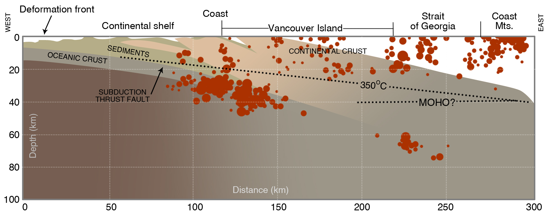
This “corner problem” explains the distribution of slab earthquakes beneath Puget Sound, but not in southwest British Columbia. Slab earthquakes occur there in two zones, even though the downgoing Juan de Fuca Plate there is relatively straight. One zone is a northward continuation of the Puget Sound deep zone, and it dies out near Vancouver (Figure 5-1). The other zone is beneath the west coast of Vancouver Island and it has lots of earthquakes (Figure 5-9). Leiph Preston and Ken Creager of the University of Washington have found earthquakes in this western zone as far south as southwestern Washington. These earthquakes tend to occur in the oceanic mantle of the Juan de Fuca Plate whereas earthquakes of the eastern zone are more likely in the oceanic Juan de Fuca crust (Figure 2-5).
Why should the slab have earthquakes beneath the straight subduction zone in British Columbia, but not the straight subduction zone in Oregon? Seismologists at the Pacific Geoscience Centre in Sidney, B.C., are quick to say that “we really don’t know.” The deeper zone of high seismicity may correspond to a downward increase in the dip of the subducting slab beneath Vancouver Island and the mainland coast, producing a bend in the slab (Figure 5-9). The zone beneath the west coast of Vancouver Island may correspond to a shallower bend, but seismologists disagree on this point.
We have assumed that Oregon has a hazard from slab earthquakes, just as Washington does, even though it has not had any big slab earthquakes in historical time, with the possible exception of the 1873 earthquake near the California border, considered further below. Perhaps the Puget Sound earthquakes are in a temporal cluster, an increase in slab earthquakes over nearly a century, and at some future time, Oregon might have a similar cluster. But not only does Oregon lack large slab earthquakes, it also has essentially no small ones either, whereas these are abundant in western Washington and in northern California (Figure 5-1). It is difficult to explain the lack of slab seismicity by saying that the slab is fully locked, because the earthquakes farther north are broadly distributed and are not localized on a few faults within the slab. Ivan Wong of URS Greiner Associates (2005) suggests that the Oregon slab is younger than it is in Washington, and the convergence rate between the Juan de Fuca and North America plates may be slower than in Washington. In addition, the crust of western Oregon is underlain by Siletzia basalt, which, as stated above, keeps the temperature of underlying Juan de Fuca Plate too hot to generate slab earthquakes. Wong also reanalyzed the 1873 Brookings earthquake, previously believed to have occurred in the Juan de Fuca Plate, and concluded that this earthquake was crustal, like similar earthquakes in northern California. The implication of Wong’s observations is that western Oregon faces hazards from the subduction zone and earthquakes in the crust, but unlike western Washington, does not face a hazard from the Juan de Fuca Plate. However, this idea is speculative, and not confirmed enough for Oregonians to relax and not worry about slab earthquakes like those in Washington.
Another mystery is that wherever the deep slab is seismically active, the overlying continental crust is active, too. The crustal seismicity is high beneath Puget Sound where the slab seismicity is high. In Northern California, both the Gorda Plate and the overlying and adjacent continental crust are characterized by frequent earthquakes. On Vancouver Island, the largest crustal earthquakes occurred on the onshore projection of the Nootka Transform Fault, and they were characterized by left-lateral strike-slip faulting, just as earthquakes on the Nootka Fault are.
If our speculations about a bending origin for the localization of seismicity are correct, there should be no relationship between earthquakes in the slab and earthquakes in the crust. Yet they appear to be somehow tied together, even though the seismicity zones in North American crust and in the Juan de Fuca Plate are generally separated by lower crust that is too hot and ductile to produce earthquakes (Figure 5-9). These questions, now being addressed by seismologists in Canada and the United States, are of practical importance because they bear on estimates of hazards in the Pacific Northwest and the Vancouver-Victoria region.
In summary, the three largest slab earthquakes in the Puget Sound region were characterized by very large areas of intensity VII, but only the 1949 earthquake had a very large area of intensity VIII. There were no areas of higher intensity, such as one would expect for crustal earthquakes of the same magnitude, probably due to the greater distance from the source to the ground surface. Unlike crustal earthquakes, the Puget Sound slab earthquakes, including the 1939 and 1946 Puget Sound earthquakes, lacked significant aftershocks. A deep earthquake off the west coast of Vancouver Island on December 16, 1957, with M 5.9, had only one aftershock, and intensities recorded were not much higher than III. The Nisqually Earthquake had four aftershocks in the following two weeks.
Even though the slab earthquakes beneath western Washington have caused most of the damage and loss of life in the Pacific Northwest, the general conclusion is that the Juan de Fuca Plate beneath the edge of the North American continent is not capable of storing enough strain energy to produce earthquakes much larger than the M 7.1 event of April, 1949 beneath Puget Sound. But the downgoing plate, covered as it is by continental crust, is still not well enough known to make this statement with a lot of confidence.
Suggestions for Further Reading
Preston, L. A., K. C. Creager, R. S. Crosson, T. M. Brocher, and A. M. Tréhu. 2003. Intraslab earthquakes: Dehydration of the Cascadia slab. Science, v. 302, p. 1197-1200.
Rogers, A.M., T. J. Walsh, W. J., Kockelman, and G. R. Priest, eds. 1996. Assessing earthquake hazards and reducing risk in the Pacific Northwest. U.S. Geological Survey Professional Paper 1560, 306 p.
Staff of the Pacific Northwest Seismograph Network. 2001. Preliminary report on the MW = 6.8 Nisqually, Washington earthquake of 28 February 2001. Seismological Research Letters, v. 72, p. 352-61.
Thorsen, G. W., compiler. 1986. The Puget Lowland earthquakes of 1949 and 1965.Washington Division of Geology and Earth Resources, Information Circular 81, 113 p.
Washington Division of Geology and Earth Resources Staff. 1999. July 2, 1999, Satsop earthquake. Washington Geology, v. 27, no. 2/3/4, p. 28-29. Includes an account by John Hughes of The Daily World, Aberdeen.
Washington Division of Geology and Earth Resources Staff. 2001. Nisqually earthquake issue. Washington Geology, v. 26, no. 3, p. 2-21.
Wong, I.G., 2005, Low potential for large intraslab earthquakes in the central Cascadia Subduction Zone: Seismological Society of America Bulletin, v. 95, p.1880-1902.
