9 Tsunami!
“If the earth shakes east and west the sea will rise up … The earth did truly shake from the west and everything on the earth fell down …. [A brother and sister] ran on up the hill and the water nearly overtook them …. The water was also coming up the mountain from the east because all the streams were overflowing …. After ten days the young man went down to look about and when he returned, he told his sister that all kinds of creatures both large and small were lying on the ground where they had been left by the sea. ‘Let us go down’ his sister said …. But when they came there, there was nothing, even the house was gone. There was nothing but sand. They could not even distinguish the places where they used to live.”
From a Tolowa legend recorded by P. E. Goddard in the early 1900s, apparently describing a tsunami on the north coast of California
1. The Easter Weekend Tsunami of 1964
The warning about a cataclysmic earthquake on the Cascadia Subduction Zone has a mythical cast to it, as if the Earth could not in fact shudder and gyrate in the way scientists have stated it would. But this doomsday scenario is based on an actual subduction-zone earthquake that wracked southern Alaska without warning on Good Friday, March 27, 1964. Alaska is not a heavily populated state, of course, and it had even fewer people in 1964 than it does now. So the human toll was less than that of, say, the Kobe Earthquake in Japan, which was more than a hundred times smaller. But the area of destruction was enormous, stretching for great distances, devastating the city of Anchorage and small towns hundreds of miles away.
The instantaneous effects on the landscape were of a scale seen only once before in this century, in southern Chile in May 1960. Parts of Montague Island in the Gulf of Alaska rose more than thirty feet into the air. Farther away from the subduction zone, a region five hundred miles long and almost a hundred miles across, extending from Kodiak Island to the Kenai Peninsula and Anchorage and the mountains beyond (Figure 4-14), sank as much as eight feet, so that sea water drowned coastal marshes and forests permanently, just as the last great Cascadia Earthquake had drowned the coastline from southern Oregon to Vancouver Island three hundred years ago.
The sudden change in elevation of the land had its equivalent on the sea floor, causing fifty thousand square miles of ocean floor to be abruptly heaved up or dropped down. This produced an effect entirely separate from the earthquake waves that radiated outward through the crust to lay waste to the communities of southern Alaska. The depression and elevation of the sea floor generated an unseen wave in the sea itself that rushed out in all directions. Fifteen minutes after the first subduction-zone rupture had permanently dropped the coastline, a monstrous ocean wave twenty to thirty feet high roared up Resurrection Bay toward the burning city of Seward, carrying ahead of it flaming wreckage, including a diesel locomotive that rode the wave like a surfboard. Residents living near the Seward Airport climbed onto their roofs as the first wave smashed through the trees into their houses, carrying some of them away. Then came a second wave, as strong as the first.
But Seward was ablaze because it had already been hit by a different kind of sea wave, striking less than sixty seconds after the beginning of the earthquake, when the ground was still shaking violently. A section of waterfront slid piecemeal into Resurrection Bay. This landslide triggered three waves up to thirty feet high that reverberated throughout the upper part of Resurrection Bay until the first tectonic tsunami wave arrived fourteen minutes later. Thirteen people died.
Similar scenes were played out in Cordova and Valdez. The entire waterfront of Valdez dropped into the harbor, and the submarine landslide generated monster waves over one hundred sixty feet high, taking thirty lives. Valdez ultimately would be relocated to safer ground.
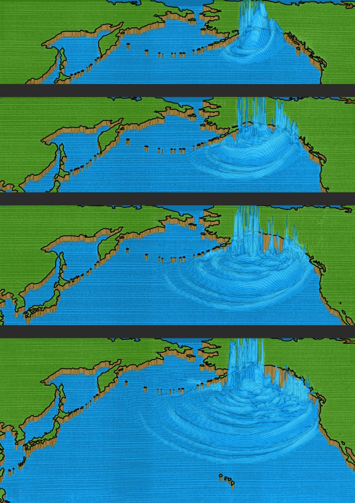
These were the waves that headed to the nearby Alaskan shore. But other waves rolled silently southward into the Pacific Ocean at hundreds of miles per hour (Figure 9-1). A ship on the high seas might encounter these long-period waves, and its crew would not be aware of them. There would just be an imperceptible lifting of the hull as the waves passed underneath. But when a wave entered shallow water, it slowed down and gained in height until it towered above the shoreline in its path. The movement of the sea floor that had triggered the tsunami had a directivity to it, preferentially southeast rather than south toward Hawaii or southwest toward Japan (Fig. 9-1). The Alaska Tsunami was like a torpedo fired directly at the coast of Vancouver Island, Washington, Oregon, and California.
An hour and twenty-six minutes later, the Pacific Tsunami Warning Center at Ewa Beach, Hawaii, issued a tsunami advisory indicating that a sea wave could have been generated by the earthquake. None had yet been confirmed, despite the damage to towns along the Alaska coastline, mainly because communications between Alaska and Hawaii had been lost. The main concern at the Tsunami Warning Center was for a tsunami in Hawaii, similar to previous destructive tsunamis in 1946, 1952, 1957, and 1960. The warning center gave an expected arrival time of the tsunami in Hawaii.
Fifty-three minutes after the tsunami advisory was issued, a report from Kodiak Island, Alaska, told of seismic sea waves ten to twelve feet above normal. Thirty-five minutes later, a second report was received from Kodiak, and, based on those two reports the Pacific Tsunami Warning Center upgraded its tsunami advisory to a tsunami warning. At almost the same moment, nearly three hours after the earthquake, the tsunami made landfall on the northern tip of Vancouver Island.
The western slope of Vancouver Island was carved by great Pleistocene glaciers, and when the glaciers melted, they left narrow, steep-walled canyons that filled with seawater and became fjords. The fjords concentrated the force of the tsunami like air scoops, with the effect that towns at the landward end felt the worst effects of the waves.
The tsunami swung left past Cape Scott into Quatsino Sound and bore down on Port Alice, ripping away boat ramps and seaplane moorings, flooding buildings, floating twelve houses off their foundations, and tumbling thousands of feet of logs along the waterfront like jackstraws. Farther south, the wave entered Esperanza Inlet and swept buildings off their foundations in the village of Zeballos, at the head of the fjord. Next it was the turn of Hot Springs Cove, an Indian village where eighteen houses were damaged. At Tofino, the wharf was damaged and the water pipeline on the sea floor was breached. Log booms were damaged, and a fishing boat sank at Ucluelet.
Near Ucluelet, the wave turned inland into Barclay Sound, thundering past Bamfield Lighthouse and a group of fifty startled teenagers on Pachena Beach. The lighthouse raised the alarm, which gave ten minutes’ notice to the twenty-five thousand residents of Port Alberni, at the head of the fjord nearly two-thirds of the way across Vancouver Island. Larry Reynolds, eighteen, raced from his house on high ground to watch after the first wave had hit at 12:10 a.m. on March 28, knocking out the tide gauge. As the second and most destructive wave surged into the street at 2:00 a.m., Reynolds could hear people screaming and could see men running in front of the wave as it crashed into the town. The lights along the waterfront went out, and the ground floor of the Barclay Hotel, one mile inland, was splintered. Two large two-story houses were lifted from their foundations; they floated serenely out into the Somass River, where they broke up and sank. A row of six tourist cabins along the river bank bowed gracefully as they rose up simultaneously, but then they came down separately as the wave passed. The third wave at 3:30 a.m. was highest of all, but the tide was going out, and the wave did little additional damage. Smaller waves continued to be felt in Alberni Inlet for the next two days. Two hundred and sixty homes were damaged, sixty severely. Economic losses in Port Alberni were $5 million in 1964 Canadian dollars.
Port Alberni was the southernmost town at the head of a fjord, and so the wave rolled southeast across the Strait of Juan de Fuca, and it was recorded by the tide gauge at Neah Bay. Logs were scattered in Quilcene Bay near Hood Canal. But the main tsunami continued on past Cape Flattery and the wild, uninhabited coastline of Olympic National Park. Incredibly, no lives had been lost on Vancouver Island nor on the Washington side of the Strait of Juan de Fuca.
By this time, warnings of the oncoming tsunami were being broadcast throughout the Pacific Northwest. One of those who heard the warning was Mrs. C. M. Shaw, whose daughter and son-in-law were spending the weekend at Kalaloch Resort in Olympic National Park with their eleven-year-old daughter, Patty, along with another couple, Mr. and Mrs. Charles W. Elicker, and the Elickers’ eleven-year-old son, Drew. Mrs. Shaw phoned the resort, and an employee found Elicker. Horror-struck, Elicker raced for the beach, where the two children had been given permission to camp for the night. Elicker routed them from their sleeping bags, and Drew raced for a forty-foot embankment of clay with a sparse cover of salmonberry. But Patty wanted to collect her pup tent and sleeping bag. Elicker realized that there was no time. In the moonlight, he could see the great wave rumbling toward them, a churning wall of water jumbled with logs and driftwood. He grabbed Patty’s hand and they raced toward the embankment and safety.
But Elicker was losing the race with the tsunami. Gripping Patty’s hand, he scrambled up the embankment, grasping at brush, and he finally managed to cling to a spindly tree as the wave drenched them up to hip level. As the initial surge retreated, Elicker climbed higher, where another part of the wave hit them at leg level. But they were safe. The next day, they found Patty’s pup tent and sleeping bag a half mile down the beach.
On came the wave down the coast, refracting to the east and heading for shore at a low, oblique angle. It struck the Quinault Indian Reservation, startling four Tacoma men from their tent on the beach at Taholah, south of Pt. Grenville.
A half mile north of the tiny community of Copalis Beach, Mr. and Mrs. David Mansfield and their children Robert, twenty, Linda, fourteen, and David, seven, were camped on the beach in their trailer. They had been up until eleven o’clock, walking on the beach in the moonlight. Shortly after they turned out the light, their trailer began to rock, and as they looked outside their window they saw their car floating away. The trailer began to roll, with the Mansfields still inside, and they suddenly found themselves tumbling outside the trailer, under water. They swam toward land, but as they tried to reach a place where they could stand, they were battered by a huge log that threatened to crush them. Linda was drifting away, but Robert grabbed her and finally, miraculously, they all reached firm ground. The force of the waves had torn off most of their clothes; all Mrs. Mansfield had on was a T-shirt when they wandered into a tavern looking for help.
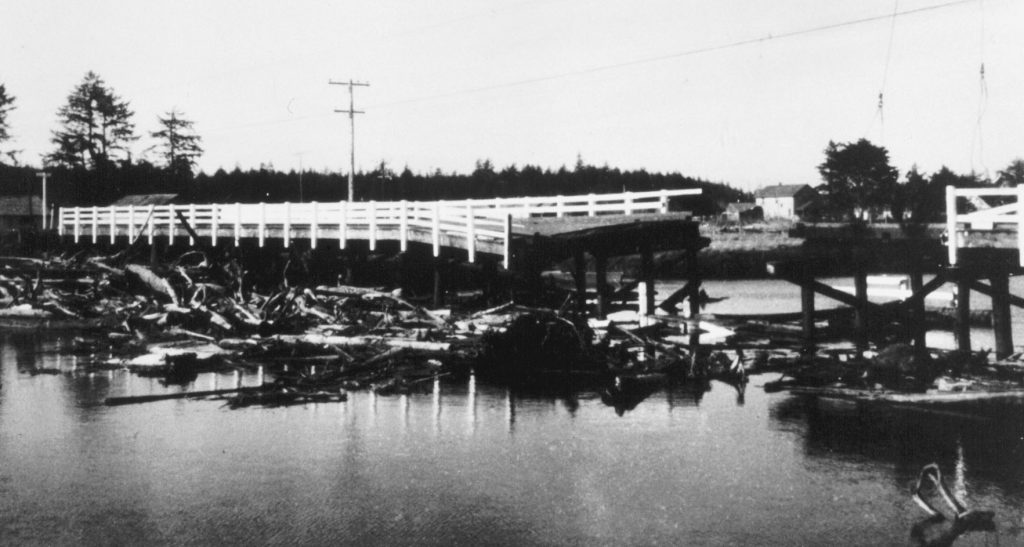
The wave then reached Copalis Beach itself, where the firehouse siren in the shopping area began to wail an alarm. Leonard Hurlbert dashed out of the Surf and Sand Restaurant, where his wife worked in the kitchen, to race home and check on their sleeping children. He was driving close to fifty miles an hour when he reached the bridge across the Copalis River (Figure 9-2). A few seconds earlier and he would have made it. But he reached the bridge at the same time as a wall of water from the sea. The bridge began to buck and heave, and over it went, pitching Hurlbert, still in his car, into the river. Trapped underwater, he forced open the door on the driver’s side against the pressure of the water. But as he was escaping, he found his leg pinned between the top of the door and the roof of the car. With the desperate force of a drowning man, Hurlbert somehow freed his leg and hurled himself toward air, severely damaging the ligaments in his left arm as he did so.
The tsunami roared through an inlet north of Westport into Grays Harbor, where three log rafts of the Saginaw Shingle Co. broke up and had to be cleared by tug. In the northern part of Willapa Bay, strong currents damaged oyster beds, transporting oysters more than a half-mile away, and burying other beds beneath sand. The Moore Cannery building was lifted off its foundation so that it slammed into the south approach of the Highway 101 bridge across the Bone River.
And still the giant waves rolled relentlessly south, past four Renton boys driven from their tent at Long Beach, past Cape Disappointment to the Oregon coast, where the tsunami turned deadly. At Seaside, on a sandbar separated from the mainland by a channel, the waves pushed the Necanicum River back up its bed, overflowing and drowning out a trailer park. Mary Eva Deis, fifty, died of a heart attack when the waves struck her house. Farther south at Cannon Beach, a wharf was swept away, carrying several small boats out to sea. Several houses were ripped from their foundations.
At Beverly Beach, north of Newport, Monte McKenzie, a Boeing engineer from Seattle, his wife Rita, and their four children—Louis, eight, Bobby, seven, Ricky, six, and Tammy, three—had come to spend the Easter weekend camping. On Friday, they were following a trail along the coast when they found a driftwood shelter. What an experience to camp directly on the beach on such a beautiful spring weekend! They got permission from the caretaker of Beverly Beach State Park to camp there. They had settled in for the night when a small wave caught them in the shelter. They had time to grab the kids, and they were running for the beach cliff when the first of the great waves struck. Rita was a senior Red Cross lifesaver and had taught all her children to swim. She gripped two of them by the hands, but great, shifting logs knocked her unconscious. Monte was thrown against the cliff, where he climbed up and vainly tried to flag down cars on Highway 101. He ran to the caretaker’s house, and police were called, but it was too late. Rita was found on the beach four hundred yards away from their campsite, battered but alive. But the kids were gone. They found Ricky’s body, but the other three were never recovered.
The tsunami swept down the Oregon coast, tearing out docks and smashing small boats at Gold Beach at the mouth of the Rogue River, and on into California. Crescent City lay in its path.
The California Disaster Office issued a bulletin at 11:08 p.m. to emergency response officials and the California Highway Patrol in all coastal counties that a tsunami was possible. This bulletin was received at the Del Norte County Sheriff’s headquarters, and by 11:20, the civil defense director and the sheriff had arrived at headquarters. At 11:50, the California Civil Defense Office estimated the arrival time of the tsunami at midnight. By the time a second bulletin had arrived at 11:50, sheriff’s deputies had been sent to low-lying areas to warn people of a possible sea wave. However, they did not order an evacuation.
The first wave arrived on schedule at 11:59 p.m., after the warning had been repeated by both radio stations. But the first wave was fairly small, reaching across the beach only to Front Street and doing little damage other than depositing some debris. Civil Defense authorities had received a report from Neah Bay, Washington, that the tsunami had done no damage there. People began to relax. The next wave at 12:40 a.m. on March 28 was larger, but still not too bad. The sea waves were behaving like tsunamis that had hit Crescent City in 1946, 1952, 1957, and 1960: flooding some low-lying areas and that was about it. The worst appeared to be over, and some people headed for their homes or to the waterfront to survey the damage to their businesses and begin to clean up. The sheriff’s office still had not issued a general alarm.
Then at 1:20 a.m. came the third wave, a giant wall of water fifteen feet high that breached a jetty, smashed into the fishing fleet at Citizens Dock at Elk Creek, and roared across Highway 101 south of town. Jack McKellar and Ray Thompson had gone down to the harbor earlier to check on Thompson’s boat, the Ea. As they loosened the moorings, the wave spun the Ea around like a top, and the boat shot out of the harbor into the open sea. The two men were carried so far from shore that they were spared the worst effects of the tsunami.
The wave caved in the west wall of the Long Branch Tavern at Elk Creek, terrifying the patrons when the lights went out. People jumped up on the bar and juke box, with scarcely any headroom for breathing. Everyone climbed up onto the roof, and Gary Clawson and Mack McGuire swam out to get a boat. When they returned, seven people, including Clawson and his parents, got into a rowboat. The water was smooth, and they headed across Elk Creek toward Front Street. They were only a few boat-lengths away from the stream bank when the drawdown began, pulling the boat sideways toward the Elk Creek bridge. Bruce Garden lunged and grabbed the bridge, which kept him from going under. The other six were slammed against a steel grating on the far side of the bridge, choked with debris. Clawson, a strong swimmer, came up for air, and as the water receded he tried to revive the others. But the other five passengers drowned in the darkness.
The fourth wave at 1:45 a.m., largest of all, crested at nearly twenty-one feet. Peggy Sullivan, six months pregnant, saw the waves from the front door of her room at Van’s Motel. She told her son Gary, nine, to dress, and threw a quilt around her twenty-three-month-old daughter Yevonne. As they stepped outside with Yevonne’s bottle, a wall of water came toward them, carrying houses like matchboxes. Gary was carried off in one direction and Sullivan and the baby in the other: Peggy’s shoes and the baby’s quilt were torn away at the same time. She was swept down the driveway and became jammed against a sports car, driftwood piled at her back, but still held onto Yevonne and her bottle. Gary was carried into the back of a garage, where he was rescued by a stranger. Severely injured, Peggy Sullivan was taken to the hospital. Although she and her two children survived, she lost her unborn child.
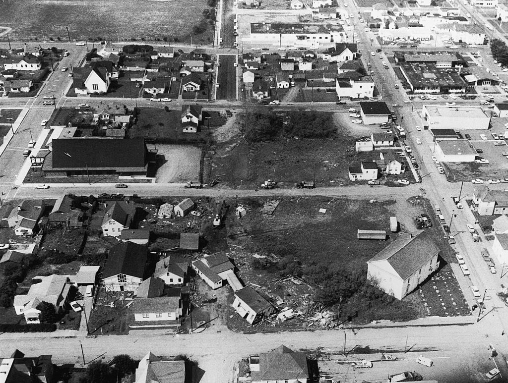
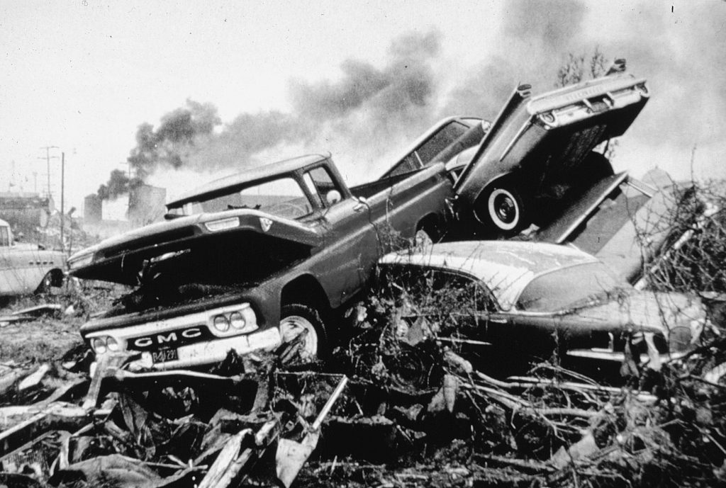
The third wave swept into downtown Crescent City, tearing out a twenty-five-ton tetrapod used in the construction of the seawall. Stores along Front Street crumbled. At first, boats were washed four blocks inland, then they and the wreckage of buildings were carried out to sea by the suction as the water retreated (Figures 9-3 and 9-4). The Texaco oil tank farm burst into flames and the tanks exploded, causing fires that burned out of control for more than ten hours.
Wally Griffin described the scene from the sheriff’s office when the lights went out: “There was a continuous crashing and crunching sound as the buildings gave way and splintered into rubble, and there were flashes from high powered electrical lines shorting out that resembled an electrical storm approaching from the east, except some of the flashes were blue. Added to the display were two explosions that could have been mistaken for thunder without the normal rolling sound.”
A big log crashed through the walls of the post office, and, as reported by Griffin, “when the water receded, it sucked the letters out like a vacuum cleaner.” The letters were later found festooning the parking lot and nearby hedges. Adolph Arrigoni, seventy, drowned in his house on B Street, and James Park, sixty, drowned when the wave floated his trailer off its foundation.
Peggy Coons, curator of the Battery Point Lighthouse on an island west of the Crescent City Jetty, had gotten up before midnight to go to the bathroom when she noticed in the moonlight that all the rocks around the island on which the lighthouse stood had disappeared. She and her husband dressed and went outside, where they saw a huge, debris-choked wave, high above the outer breakwater, bearing down on the town. Then the water roared back past them at high speed, leaving the beach strewn with debris. The second wave passed them, and they saw lights blinking out along the shoreline. Again the water drained back past them to the sea.
The third wave started fires in the town, and sparks flew. When the water drained out this time, three-quarters of a mile from the normal shoreline, it revealed the sea bottom, described by Peggy Coons as a “mystic labyrinth of caves, canyons, basins and pits, undreamed of in even the wildest fantasy.”
In the distance, Coons could see a massive black wall of water, with boiling and seething whitecaps glistening in the moonlight. A Coast Guard cutter and several smaller boats two miles offshore appeared to be riding high above the wall. The water struck with great force and split around the island, picking up driftwood logs as it struck the mainland. They saw bundles of lumber at Dutton’s Lumber Yard fly into the air as other bundles sailed away. There was a great roar, and buildings, cars, boats, and lumber were moving and shifting. Then the return wave came past them, carrying a slurry of mattresses, beds, furniture, television sets, and clothing. Coons saw more waves, but they were smaller. The damage had been done.
The waves destroyed twenty-nine blocks and left one hundred fifty businesses a total loss. Eleven people had died. Governor Edmund G. Brown asked the president to declare Crescent City a disaster area.
And still the tsunami sped south, trapping Stuart Harrington and Donald McClure, two Air Force sergeants who were eel fishing at the mouth of the Klamath River, south of Crescent City. A wall of water, choked with driftwood, picked them up and carried them a half-mile up the river. They scrambled through the driftwood to the surface, and McClure helped Harrington climb up on a larger log that appeared to offer protection. They heard a response to their cries for help. Then the water and floating logs began to rush back toward the sea, and both men slipped into the water to swim for shore. McClure had helped Harrington remove his jacket and shirt to make it easier for him to swim. Harrington swam through the maelstrom to the shore, below the boat docks, where he found to his horror that McClure, who had saved Harrington’s life, had lost his own.
The tsunami continued south of Cape Mendocino, causing havoc on the Mendocino coast. The wave was still three feet high near the Golden Gate Bridge. At Sausalito, the mooring cables of the sixty-six-year-old ferryboat Berkeley snapped, causing the ferry to list and damage the pier. Altogether, the damage to boats in San Francisco Bay amounted to nearly a million dollars. A ship ran aground at Gaviota, boats were damaged farther east at Santa Barbara, and Los Angeles suffered $200,000 in losses. Damage was reported in San Diego, and ten-foot waves struck Catalina Island off the southern California coast. An alarm was raised on the west coast of Mexico, but the tsunami, finally, was spent. Tide gauges recorded the tsunami all around the Pacific Ocean, including Antarctica; it was recorded in Peru nearly ten hours after the fourth wave struck Crescent City and nearly sixteen hours after the earthquake.
But the tsunami was not quite finished with the coast of Washington. The greatest destruction within Willapa Bay occurred the following day, twelve hours after the earthquake, near Raymond and South Bend. Ed Norman, Bill Campbell, and Ed Triplett were working at Port Dock, about a mile downstream from Highway 101, when a series of surges struck shortly before low tide. The water dropped six to eight feet, temporarily grounding a tug, then, when the current reversed, it broke up a 550-foot log raft that had been tied to Port Dock. At Bay Center, Sam Pickernell was out crabbing when a series of surges, ten minutes apart, emptied the sloughs and rolled oysters onto the shore. This lasted thirty to forty-five minutes.
What was learned? First, except for the tsunami at Seward and Valdez, Alaska, the loss of life was entirely preventable, because there was plenty of time to evacuate low-lying coastal areas even as far north as Vancouver Island. The first two waves at Crescent City were no larger than previous tsunamis, convincing local authorities that the worst was over and no evacuation order was necessary. For warnings to be heeded, people had to have their radios or television sets on; a siren powered by an emergency generator would have been more effective, combined with emergency-service personnel noisily alerting people to the danger.
A second tsunami warning center was established at Palmer, Alaska, to improve the warning system and to better understand the dynamics of tsunami wave propagation. In addition, British Columbia, Washington, Oregon, and California began to study their coastlines and offshore regions to understand better how tsunamis worked and how their effects could be dealt with.
A quarter-century would pass before Kenji Satake would develop computer models showing the directivity effects of tsunamis, the pointed gun of the Alaska Earthquake aimed directly at the west coast of North America (Figure 9-1). And there were many low-lying coastal areas that were not hard hit, indicating that the wave was strongly controlled by the bottom topography of the sea floor that channeled and accentuated the tsunami as it headed for shore.
2. Other Tsunamis in the Pacific Northwest
The 1964 tsunami was the most damaging to strike the Pacific Northwest in recorded history, but it was not the only one. Tide-gauge records show that subduction-zone earthquakes in the Aleutian Islands generated tsunamis that were detected in Tofino and Victoria, B.C., Neah Bay, Washington, and Crescent City, California. A larger tsunami resulted from the 1960 earthquake in southern Chile of M9.5, the largest of the twentieth century (Figure 4-17). Wave heights for the Aleutian-based tsunamis were about one-fourth those in 1964, and those accompanying the Chilean earthquake were about half the wave heights in 1964. For all pre-1964 tsunamis, Crescent City had the greatest wave heights, as it did in 1964, evidence that there is something special about the configuration of the sea floor off Crescent City that causes focusing of tsunami waves as they enter shallow water.
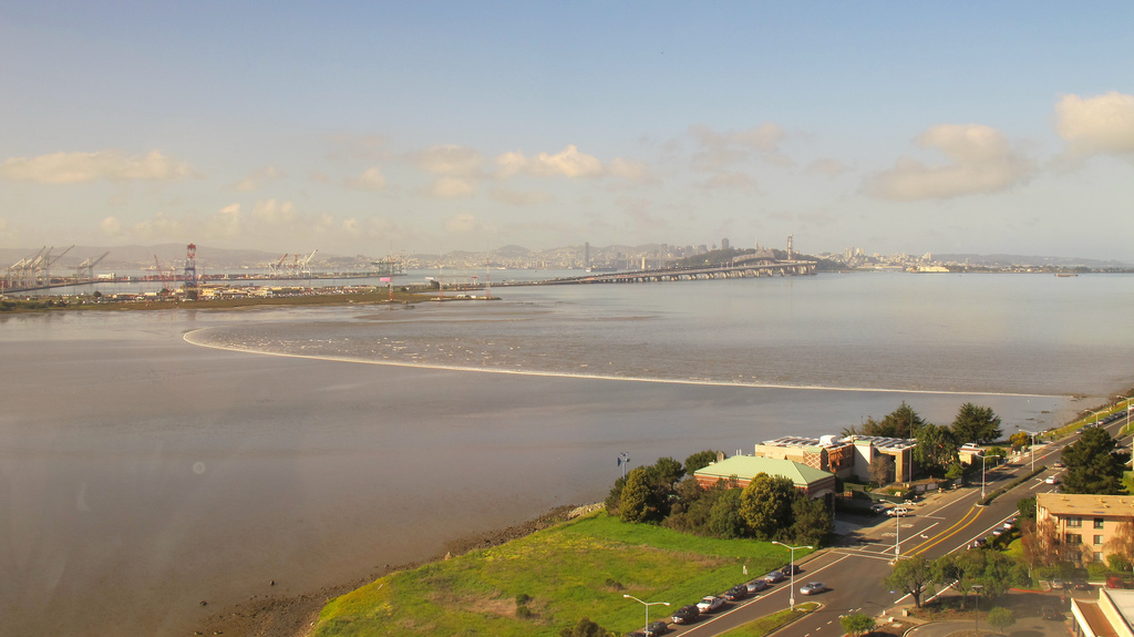
The next tsunami arrived on March 11, 2011, as a result of the subduction-zone earthquake of M 9 off Japan. That earthquake was similar to the next earthquake expected on the Cascadia Subduction Zone. Its directivity caused greater effects off the California coast than in areas farther north, but it indicated that the truly great earthquakes would have effects thousands of miles from their sources. Damage was largely restricted to small boat basins in Brookings and Depoe Bay, Oregon, and Crescent City, California. Figure 9-6 is a photo of the tsunami wave near Emeryville, California, north of Oakland.
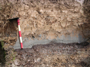
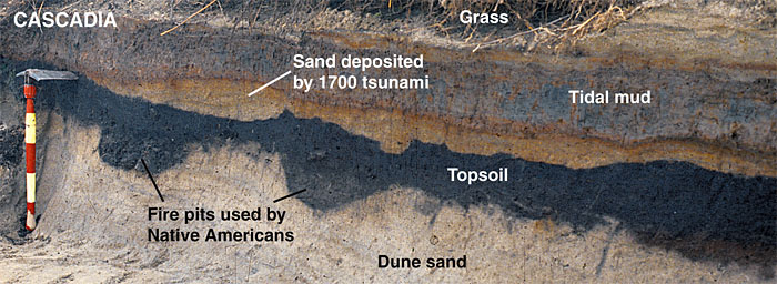
The twentieth-century tsunamis were relatively small compared with the tsunamis that struck the northeastern Japan coast on March 11, 2011 or those that accompanied the last Cascadia Subduction-Zone earthquake in January 1700. As pointed out in Chapter 4, this tsunami even did damage in Japan, more damage than the 2011 Tohoku-oki tsunami did in western North America. The buried peat deposits at Willapa Bay, Washington, and other areas are directly overlain by layers of laminated sand that were derived from the sea (Figure 9-5a). Figure 9-5b is a photo of a deposit from the 1700 earthquake that overlies Native American fire pits. Sand thickness and grain size diminish away from the sea. Tsunami sands from inlets on northwestern Vancouver Island preserve a record of both the A.D. 1700 tsunami and the tsunami that came from Alaska in 1964. In southern Oregon, Bradley Lake formed behind a sandbar, showing evidence of giant waves sweeping across the sandbar and depositing sand and marine diatoms in the lake. Thus it is likely that the next Cascadia Subduction Zone earthquake will be accompanied by a devastating tsunami. The damage will be worse in Oregon, Washington, and Vancouver Island because the tsunami will strike areas that have just subsided several feet as a consequence of the earthquake, just as coastal areas of Japan subsided during the 2011 Tohoku-oki earthquake and tsunami.
The earthquake on the Seattle Fault also produced a tsunami that was recorded at the base of Magnolia Bluff in Seattle, at the mouth of the Snohomish River near Everett, and on the south end of Whidbey Island. NOAA, in addition to planning for a tsunami on the Cascadia Subduction Zone, also is planning for a tsunami accompanying rupture of the Seattle Fault.
3. Some Facts about Tsunamis
First, a tsunami is not a tidal wave. Tides are caused by the attraction between the Moon and Earth, and tsunamis are completely unrelated. If a tsunami arrived at the same time as a high tide, as it did at Crescent City, its effects would be worse than if it arrived at low tide, because the wave could travel farther onto the land. Another term is seismic sea wave. This is correct for most tsunamis, but not all, for tsunamis can be generated by submarine volcanic eruptions or submarine landslides. The cataclysmic eruption in 1883 of Krakatau, a volcanic island in Indonesia, was followed by a sudden collapse of the central volcano and an inrush of water, generating a tsunami that, together with the eruption, killed more than thirty-six thousand people.
We use the Japanese word tsunami, from the Japanese characters for harbor wave, in light of the fact that a tsunami increases in height as it enters a harbor, as it did at Port Alberni and Crescent City (Figure 9-7).
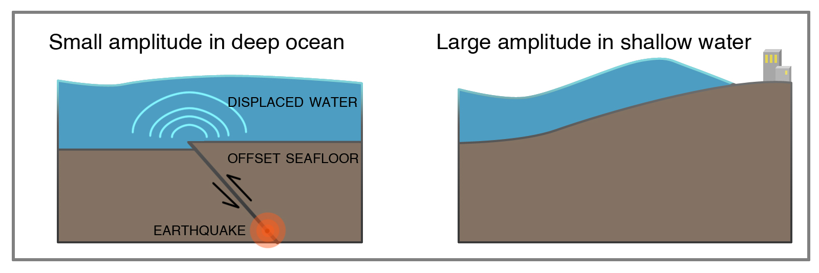
In the Alaska Earthquake of 1964, a section of sea floor more than four hundred miles long and one hundred miles across suddenly arched upward, forcing the overlying water upward and outward as if the sea floor were a giant paddle (Figures 4-14 and 9-7). Although this happened almost instantaneously, it was not the speed of the uplifted seas but the sheer volume of water displaced that produced the powerful tsunami. A tsunami generated by a sudden change in the deep ocean floor is a wave that extends from the bottom to the sea surface. The wave travels at great speed, five hundred miles an hour or faster, depending on the depth of the ocean.
The wave travels fastest through the deep ocean and slows down as it approaches the land, as can be observed in the computer simulation in Figure 9-1. The waves traveling down the coast are slower than those in the open sea, so that the wave front of the 1964 tsunami made a sweeping turn to the left and attacked the coast almost head on.
Tectonic tsunamis have very long wave periods. (Figure 3-12 illustrates wave amplitude and wavelength; the period is the length of time it takes a full wavelength to pass a point.) An ordinary ocean wave breaking on the beach has a period of five to fifteen seconds, but a tsunami generated by a subduction-zone earthquake has wave periods ranging from seven minutes to nearly an hour, depending on the origin of the tsunami. It was the long periods of twenty-five to forty minutes that caused so much havoc at Crescent City and elsewhere. The wave rushed onshore and then it receded. When this happens, observers assume that the tsunami differs from an ordinary ocean wave in size only. If the next wave does not arrive in the next few minutes, they assume that the danger is past. They return to the shore, out of curiosity or a desire to help in rescue or cleanup operations. Then, perhaps as much as an hour later, another giant wave strikes. The loss of life from the follow-up wave, which might be bigger than the first one, is commonly larger than that from the initial wave.
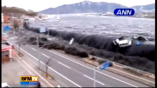
Figures 9-9 and 9-10 graphically (and disturbingly) illustrate the folly of rushing to the ocean too soon. In Figure 9-9, tourist swimmers have ventured away from shore as the next wave approaches. The sea bottom in the foreground is exposed because the incoming wave was immediately preceded by a drop in water level from the previous wave, giving the swimmers a false sense of security. The swimmers in the center of the photo realize that the next wave is approaching them, but it is too late for them. They were all drowned in the tsunami. In Figure 9-10, tourists have rushed to the shore to photograph the incoming tsunami, but the wave was much higher than they expected, and they also lost their lives.
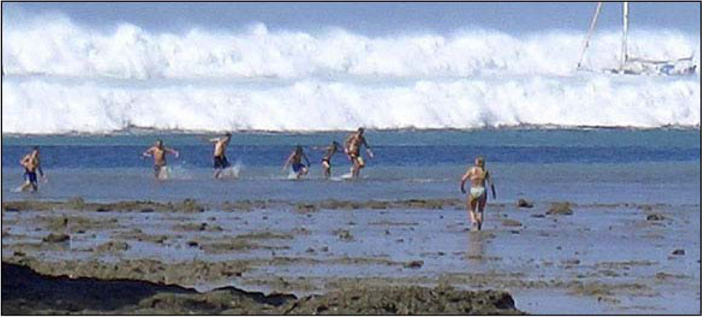
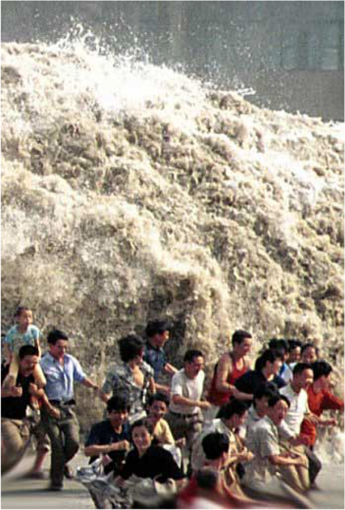
These two photos are a warning. If you hear a tsunami warning, DON’T GO TO THE BEACH; go to high ground immediately and stay there until you are told it is safe to return. It is my prayer that these two photos will save lives.
A tsunami has almost no expression on the ocean surface. (Here Figure 9-1 is misleading, because it gives the impression that great wave heights are found in the deep ocean as well as along coastlines.) The height of a tsunami on the open ocean is typically only a few feet—less than the normal surface waves, and the wave height is gradual, not like a breaking wind-generated wave. Ships at sea cannot give warning, because people on board cannot detect the passage of the tsunami beneath the ship. During a deadly tsunami that struck Hilo, Hawaii in 1946, the crew of a freighter anchored offshore was surprised to see huge waves breaking over buildings and trees onshore, because they were not strongly affected by the wave passing under their ship.
As a tsunami enters shallow water, it slows down but does not lose energy. It converts to a gigantic surface wave (Figures 9-7, 9-8, and 9-9). The way in which the tsunami approaches the shore is of critical importance in tsunami hazard analysis. It depends on the direction and energy of the approaching tsunami, of course, but it is also influenced by the configuration of the sea floor. Hilo Harbor in Hawaii is particularly susceptible to tsunamis because the adjacent sea floor is shaped like a funnel, concentrating the energy of the wave into a smaller area. In a similar fashion, the Vancouver Island fjords concentrated the wave energy of the 1964 tsunami like the nozzle of a fire hose, smashing against the communities at the heads of the fjords. Crescent City has a similar problem. Because the tsunami is controlled by water depth, even in deep water, the configuration of offshore banks and submarine canyons influences the size of a tsunami. Topographic maps of the sea floor, called bathymetric maps, are available for the west coast of the United States from the National Oceanic and Atmospheric Administration (NOAA). These bathymetric maps are important in determining which sections of a coastline are most susceptible to tsunamis.
In the 1964 earthquake, the sea floor was suddenly pushed upward and outward to the southeast, so that the first evidence of the tsunami in the Pacific Northwest was the great wave that crashed on the beaches and entered the harbors. But at Seward, Alaska, on the north side of the uplift, the force of the earthquake propagated away from the town. People at Seward saw a huge wave approaching them, but as they looked at the remains of the small-boat harbor, they observed that it had been magically drained of water. This was part of the tsunami, too, but the sea had rushed away from land rather than toward it, immediately followed by the first wave to drive into the port and town.
Seward, and Cook Inlet behind it to the northwest, abruptly subsided during the earthquake, just as the coastal marshes of central Oregon, Washington, and Vancouver Island had subsided during the great Cascadia Earthquake of A.D. 1700, and previous earthquakes as well. If the next Cascadia earthquake behaves like the illustration in Figure 4-14, then the first evidence of the accompanying tsunami in northern Oregon or Washington might be a sudden outrushing of water, followed by a great wave. Coastal areas would see exposed parts of the sea floor that people living there had never before seen exposed (Figure 9-9), even at the lowest tides. There would be a great temptation to go to the beach to see this phenomenon—which could be fatal because there would not be enough time to get back to high ground before the first wave struck (Figures 9-9, 9-10).
Computer modeling of a Cascadia Subduction Zone tsunami predicts a different outcome for northern California because the coastline is much closer to the subduction zone than it is farther north (Figures 4-12, 4-22). The northern California coast would be suddenly uplifted, whereas the coast farther north would suddenly subside (Figure 4-14).
For those people who are into extreme sports, be advised that tsunamis are NOT surfable. The wave does not curl. It generally comes ashore as a rapidly rising surge of turbulent water choked with debris, including large logs. Even if a surfer managed to avoid being bashed to death by the maelstrom of debris, he or she could never “catch” the wave.
4. Tsunami Sounds
Most observers of a great tsunami are so horrified that they remember only what they saw rather than what they heard. However, Jerry Eaton, a seismologist with the USGS, was at a bridge across the Wailuku River in Hilo, Hawaii, on the night of May 22, 1960, as a tsunami from a monster earthquake in Chile approached the city. Eaton heard “an ominous noise, a faint rumble like a distant train, that came from the darkness far out in Hilo Bay. Two minutes later, … the noise became deafening.” Carol Brown, sixteen, heard “a low rumbling noise that soon became louder and was accompanied by sounds of crashing and crunching.”
5. Tsunami Warning Systems
The tsunami at Crescent City struck more than four hours after the earthquake. Loss of communication with Alaska delayed the issuance of a tsunami advisory for nearly an hour and a half after the earthquake, and the advisory was not upgraded to a warning until two hours and twenty minutes after the earthquake—about the time the first wave was striking the north end of Vancouver Island.
The warning system in place at that time—the Pacific Tsunami Warning Center—was established in Hawaii after a disastrous tsunami in Hawaii in 1946 caused by an earthquake on the Aleutian Subduction Zone of Alaska. The Hawaii center was not designed to warn against tsunamis like the one produced by the 1964 Alaska Good Friday Earthquake, so a second warning center was set up—the West Coast/Alaska Tsunami Warning Center in Palmer, Alaska. Both are operated by NOAA. The Alaska center initially was organized to warn against tsunamis only in Alaska, but now it’s responsible for alerting Alaska, British Columbia, Washington, Oregon, and California about all earthquakes around the Pacific that might produce a tsunami.
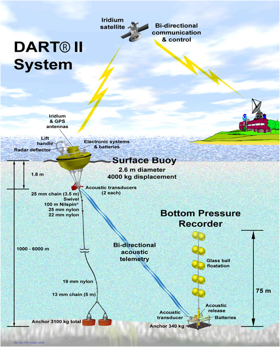
Seismographs and tide gauges around the Pacific Rim report immediately to Ewa Beach, Hawaii, and Palmer, Alaska, and tsunami arrival times are estimated for shorelines around the Pacific. The Deep-ocean Assessment and Reporting of Tsunamis (DART) Project has installed pressure gauges on the deep ocean floor, permitting tracking of tsunamis in the deep sea in real time, which has never before been possible (Figure 9-11). NOAA has a large number of DART tsunami detectors in the Pacific Ocean and a few in the Atlantic and Indian oceans (Figure 9-12). There were enough DART buoys in place that the magnitude 9 Tohoku-oki earthquake was tracked by the buoys as it traveled from Japan across the Pacific Ocean. In addition, the seismic networks in southern Alaska, western Washington and Oregon, and northern California were upgraded.
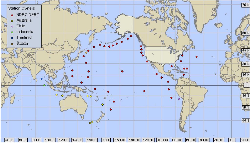
When a subduction-zone earthquake of moment magnitude 7.5 or larger strikes anywhere around the Pacific Ocean (magnitude 7.0 or larger on the Aleutian Subduction Zone), the tsunami warning centers swing into action. After the epicenter of the earthquake has been located from the seismic network (commonly within a few minutes) and the earthquake is confirmed as shallow, rupturing the subduction zone, the travel time of a potential tsunami is estimated, and stations near the epicenter are alerted. A tsunami warning is issued to all communities within three hours of the first wave. For communities three to six hours away from the first wave, a tsunami watch is established. For coastal regions that are still farther away, an advisory bulletin is issued and is updated as more information becomes available, such as confirmation of a tsunami by observers, tide gauges, or deep-sea DART pressure gauges. For the West Coast, the tsunami warning would come from Palmer, Alaska. As the tsunami advances, its progress is monitored, and the warning is updated with new projected arrival times of waves and possible wave heights. This gives time for local authorities to order evacuation of low-lying areas. If a tsunami warning is issued for Hawaii, evacuation of low-lying areas is mandatory, but in other states, the decision to evacuate is made by local authorities.
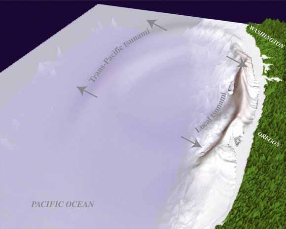
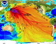
Computer modeling of tsunamis gives more confidence to the warnings, although modeling is not yet used by the tsunami warning centers in issuing warnings or alerts. This might change, because models can take into account the strong directivity of tsunamis (Figures 9-13, 9-14). It’s important to learn not only the location of the epicenter and the magnitude of an earthquake, but also the direction of motion of the ocean floor, which can be determined by studying the wave forms of seismograms of the mainshock recorded at many seismograph stations. Armed with such information, the warning of the 1964 Alaska tsunami could have been more strongly directed to the west coast of North America and less toward Japan, which recorded the tsunami but suffered no damage.
A tsunami wave was once compared to the waves in a pond radiating out from a pebble that is thrown into it, with the pebble representing the earthquake. The directivity of a tsunami leads to a better analogy. It’s more like throwing a log into the water; waves in front of the log are much higher than the waves at the ends.
Tsunami warning systems worked well for two distant tsunamis that traveled great distances: the tsunamis of 1952 and 1957. But they were of limited value in saving lives from the 1960 Chile tsunami that traveled from Chile to Japan, and the 1964 Alaska tsunami that did damage as far away as southern California. Furthermore, more than 75 percent of the tsunami warnings have been false alarms. Nevertheless, a partnership among the USGS, NOAA, and the five western states called CREST (Consolidated Reporting of Earthquakes and Tsunamis) has reduced the response time from more than ten minutes to less than two minutes for the 2001 Nisqually Earthquake.
What about warnings to coastal areas when the earthquake occurs on a fault that is just offshore? Tsunami warnings were of no use to towns in southern Alaska struck by the 1964 tsunami. How about an earthquake on the Cascadia Subduction Zone or on the Seattle Fault in Puget Sound? There is little time—perhaps less than ten or fifteen minutes—before the first wave reaches the coast (Figure 9-13). A tsunami struck Okushiri Island off the northwest coast of Japan only two to three minutes after a large offshore earthquake, killing schoolchildren on the beach.
The best advice now for regions subjected to subduction-zone earthquakes is to get to high ground immediately when the shaking from a great earthquake stops long enough to allow one to move. Don’t wait for a tsunami warning. The Cascadia tsunami off the Oregon coast will arrive within 20 minutes of strong ground motion.
Some earthquakes generate tsunamis that are unusually large for the amount of shaking they cause. This can happen for two reasons. Some earthquakes are characterized by motion of the ground that is so slow that little shaking damage occurs, even though the earthquake magnitude is large. A slow earthquake in Nicaragua on September 2, 1992, produced a tsunami that killed hundreds of coastal villagers, even though the amount of shaking was deceptively small. If a slow earthquake struck a coastal area, people might not take seriouesly the tsunami potential of the earthquake seriously until it was too late.
The second reason is that an earthquake can trigger a submarine landslide. On July 17, 1998, more than twenty-two hundred villagers along a fifteen-mile stretch of the north coast of Papua New Guinea lost their lives in a tsunami that was generated by an earthquake of M 7.1. The earthquake apparently caused a submarine landslide, and the earthquake and landslide together produced a tsunami with wave heights of thirty to forty-five feet. The tsunami arrived about twenty minutes after the earthquake. In contrast to the long periods of tsunamis from a distant source, the Papua New Guinea tsunami had wave periods of one to five minutes. Landslide-generated tsunamis are of particular concern to the Pacific Northwest; huge landslides off the southern Oregon coast mapped by Chris Goldfinger probably generated large and devastating tsunamis.
In the 1964 Alaska Earthquake, Seward and Valdez were hit by tsunamis from two different sources. The first one was triggered by submarine landslides immediately offshore, extending onshore and causing collapse of the waterfronts of both towns. In some areas, waves began to strike less than sixty seconds after the beginning of the earthquake, while strong shaking was still going on. The landslide-generated tsunamis caused the largest waves, more than one hundred sixty feet high at Valdez, with waves bouncing off the sides of the narrow bays leading into the towns for ten to fifteen minutes. Then, about fifteen minutes after the beginning of the earthquake, the tectonic tsunami arrived, generated by the sudden change in depth of the sea floor in Prince William Sound. The tsunamis were worse because both towns are at the heads of narrow fjords. This concept is illustrated for Cascadia in Figure 9-13. One set of tsunamis heads toward the Northwest coast, taking about 15 to 20 minutes after the earthquake to arrive. The other set heads west into the Pacific Ocean, arriving in Japan and other areas several hours later, allowing a warning to be issued for Japan.
The 1992 Cape Mendocino Earthquake generated a small tsunami that arrived at Eureka twenty minutes after the earthquake and at Crescent City forty-seven minutes after the quake. Waves continued to arrive for about ten hours, with the strongest waves eighteen inches high at Crescent City almost four hours after the earthquake.
As was shown in the 1964 tsunami, a warning system needs more than notification by radio. A siren system would wake people up if the tsunami struck at night, as it did in 1964. The siren at Copalis Beach, Washington, probably saved lives in 1964. However, a siren might be knocked out by a local earthquake. Crescent City now has a siren, but it will be activated for distant tsunamis only. If a siren system is proposed for your community, make sure that funds are provided to maintain and test it, including funds for an emergency generator.. The county emergency manager (see Chapter 14) is a logical person to be responsible for a siren system.
6. Tsunami Hazard Maps
Following the 1992 Cape Mendocino Earthquake, the California Governor’s Office of Emergency Services and the Federal Emergency Management Agency (FEMA) funded a study of the effects of an earthquake of M 8.4 on the Cascadia Subduction Zone for the 150-mile distance across Humboldt and Del Norte counties between Cape Mendocino and Cape Blanco, Oregon. This was published by the California Division of Mines and Geology as Toppozada et al. (1995). As part of this scenario, NOAA produced tsunami inundation studies of the Crescent City and Humboldt Bay areas. In the scenario, the tsunami arrived just minutes after the earthquake, which meant that there was not enough time to order an evacuation. Waves were higher than thirty feet. The Samoa Peninsula was inundated, as was the village of King Salmon, which faces the opening of Humboldt Bay. Earthquake damage to road approaches would prevent immediate aid from reaching the Samoa Peninsula. A possible refuge for residents would be a ridge of wooded dunes just west of Manila, two miles north of Samoa and four miles north of Fairhaven. At Crescent City, the scenario tsunami runup was higher than the 1964 tsunami, with severe damage expected in the developed area along the shoreline south of Front and M Streets.
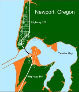
In October 1994, Senator Mark Hatfield of Oregon asked for a report on preparedness against tsunamis, especially a tsunami generated on the Cascadia Subduction Zone. A year later, the Senate requested a plan for implementation with a budget. This led to the establishment in December 1996 of the National Tsunami Hazard Mitigation Program for the five Pacific Coast states, under the direction of NOAA and in collaboration with FEMA and the USGS. This program, with a budget of about $2 million per year, supports tsunami inundation modeling in states bordering the Pacific Ocean, tsunami mitigation activities, upgrading seismic networks, and deep-ocean pressure gauges. As part of this program, the Center for Tsunami Inundation Mapping Efforts (TIME) was established at NOAA’s laboratory at the Hatfield Marine Science in Newport, Oregon. Research is underway to improve and integrate tsunami modeling with real-time observations. Tsunami inundation maps are constructed using computer models of the earthquake source as well as the configuration of the continental slope and shelf and coastal bays, harbors, and estuaries. The tsunami maps show where tsunamis are likely to be focused, such as they were at Hilo, Hawaii and Crescent City, California.
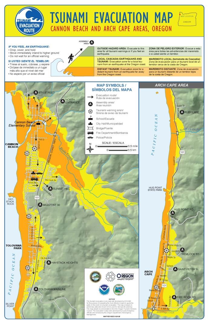
During the first year of the program, all of the mapping funds went to Oregon and Washington, with tsunami maps at Newport, Cannon Beach, and Arch Cape, Oregon (Figure 9-15a, b). In 1995, Oregon enacted legislation that limits construction of new essential facilities and special-occupancy structures in tsunami flooding zones, although the NOAA research lab investigating tsunamis at the Hatfield Marine Science Center is, unfortunately, within the tsunami inundation zone. Directed by this new law, the Department of Geology and Mineral Industries (DOGAMI) prepared a series of tsunami hazard maps at a scale of one inch to 2,000 feet of the entire Oregon coast (available as Open-File Reports O-95-09 through O-95-66 and explained in O-95-67, which also contains an index map of the individual tsunami warning maps). If you live at the coast, you can obtain a map of your area from DOGAMI.
In the 1990s, DOGAMI designed a tsunami warning logo to be posted on Oregon beaches. This logo (Figure 9-16) now has been adopted around the world. The tsunami logo is seen along Highway 101 where the road drops in elevation to within the tsunami runup zone. Evacuation routes are identified by the logo and an arrow showing which direction to evacuate. At my condo at Nye Beach in Newport, we designed an evacuation map that is posted in all condo units, including the instructions to not depend on elevators or your car to get you away from the inundation zone. OSU has an extension agent, Pat Corcoran, who lives at the coast and has the responsibility of informing the public about tsunami hazards.
The National Tsunami Hazards Mitigation Program supported the preparation of a tsunami hazard map of the southern Washington coast from Taholah, north of Pt. Grenville, to the Columbia River. As in Oregon, the location of maximum tsunami runup is based on computer models including the topography of the seafloor. This study also estimated the time of arrival of the first large tsunami: thirty minutes or less for communities directly facing the Pacific Ocean like Taholah, Long Beach, and Westport, but at least an hour for communities within Grays Harbor or Willapa Bay, including Aberdeen, Hoquiam, and Bay Center. NOAA is also preparing scenarios for a tsunami following an earthquake on the Seattle Fault, which would produce large waves in Elliott Bay in downtown Seattle.
What warning should be given to coastal residents in case of an earthquake? On the Oregon and Washington coast, strong shaking is likely to mean an earthquake on the subduction zone, and residents are advised to evacuate to higher ground without waiting for a tsunami warning. But what about crustal earthquakes that do not generate tsunamis? The city of Santa Cruz, California, underwent strong shaking during the 1989 Loma Prieta Earthquake, and Santa Monica was damaged by the 1994 Northridge Earthquake; neither earthquake generated a tsunami. Should the residents evacuate without official notice in earthquakes like those? Probably not. Even the 1906 San Francisco Earthquake, which had its epicenter offshore west of the Golden Gate, did not generate a tsunami large enough to warrant evacuation.
Attention has also been given to locations where residents would not have time to evacuate to high ground. At Cannon Beach, for example, a stream lies between the beach and high ground (Figure 9-15b). Evacuation drills have suggested that fifteen or twenty minutes would not be enough time to get everyone to high ground, particularly people with disabilities. The bridges would be jammed with cars. In this case, an alternate option is vertical evacuation: to the upper floors of beachfront hotels. Figure 9-17 shows an alternative: put your beachfront home on stilts! An Oregon coastal town proposed a new city hall using this principle, but the decision makers were unable to follow through with raising the money to do it.
7. Seiches
A fascinating subculture in Seattle and, to a lesser extent, in Portland, comprises people who live on the water in houseboats, with the largest number on Lake Union in Seattle. This is not inexpensive living; recent real-estate listings were from half a million to nearly a million dollars for a floating home. There are enough houseboaters to have their own neighborhood community council called the Floating Homes Association. People who live on dry land are known as “uplanders.”
On a sunny Sunday afternoon, November 3, 2002, Ed Waddington was on the second floor of his floating home on Lake Union reading the newspaper when his boat began to move and rock. The usual reason a houseboat starts to rock is a passing boat exceeding the speed limit of seven knots, but the rocking motion continued for at least five minutes, too long for a boat wake. Log rafts on which houseboats are built were bashing into one another and into piers, and chains were snapping taut. Waddington walked to the end of his pier, where he and several of his neighbors flagged down a police boat. The police officer told him that he had been dispatched by the Harbor Patrol base on Northlake Way to look for speeders. But there were none.
Waddington turned on his radio and heard a report of an earthquake in central Alaska, the Denali Earthquake, of magnitude 7.9. As a professor in the Department of Earth and Space Sciences at the University of Washington, he put two and two together and recognized that the houseboats in Lake Union were feeling the Denali Earthquake thousands of miles away. Surface waves from this earthquake with a period of about twenty seconds were strong enough to cause the sloping lake bottom to move, so that the water sloshed and produced damaging surface waves, but these surface waves were too slow to be felt by the “uplanders.” At least twenty houseboats were damaged.
Sloshing water was reported elsewhere, including a five-foot wave at Lake Wenatchee, and high waves on Puget Sound, Lake Washington and on Henry Hagg Lake, Oregon. Both Ross Lake and Lake Chelan in Washington were affected. Water sloshed out of swimming pools. According to Aggeliki Barberopoulou, then of the University of Washington, the concentration of damage at Lake Union and Portage Bay was due to the focusing of seismic waves by the thick Seattle sedimentary basin underlying Lake Union, in addition to the large number of houseboats around the lake.
Barberopoulou’s conclusion is supported by reports of a seiche on Lake Union after the 1964 Alaska Earthquake. About 7:45 in the evening of March 27, 1964, houseboats broke away from their moorings, and water pipes were broken. The north mooring line of the Four Winds Restaurant pulled a piling from the lake bottom, and fifty-five patrons had to be evacuated. Bartender Paul Farris reported a lot of broken glasses. At Aberdeen, on the Washington coast, water sloshed out of the city reservoir and carried gravel into a nearby neighborhood.
Videos of Tsunamis
Phuket, Thailand, tsunami, 2004
Moment Magnitude — What Happened to the Richter Scale?
Suggestions for Further Reading
Atwater, B.F., et al.,2005. The orphan tsunami of 1700 — Japanese clues to a parent earthquake in North America. U.S. Geological Survey Professional Paper 1707, 133 p. http://pubs.usgs.gov/pp/pp1707/
Atwater, B. F., V. M. Cisternas, J. Bourgeois, W. C. Dudley, J. W. Hadley, and P. H. Stauffer, compilers. 1999. Surviving a Tsunami—Lessons Learned from Chile, Hawaii, and Japan. U.S. Geological Survey Circular 1187. 18p.
Barberopoulou, A., A. Qamar, T. Pratt, K. Creager, and W. Steele. 2003. Local amplification of seismic waves from the MW 7.9 Alaska earthquake and a damaging seiche in Lake Union, Seattle, Washington. Geophysical Research Letters, DOI: 10.1029/2003GL018569.
Benson, B., K. A. Grimm, and J. J. Clague. 1997. Tsunami deposits beneath tidal marshes on northwestern Vancouver Island, British Columbia. Quaternary Research, v. 48, p. 192-204.
Bernard, E. N., et al. 1991. Tsunami Hazard: A Practical Guide for Tsunami Hazard Reduction. Dordrecht, The Netherlands: Kluwer Academic Publishers.
Clague, J. J., A. Munro, and T. Murty. 2003. Tsunami hazard and risk in Canada. Natural Hazards, v. 28, p. 433-61.
Darienzo, M. 2003. The National Tsunami Hazard Mitigation Program. Earthquake Quarterly, Summer 2003, published by the Western States Seismic Policy Council, p. 4-7, 17.
Dudley, W. C., and M. Lee. 1988. Tsunami! Honolulu: University of Hawaii Press.
Governor’s Office of Emergency Services. 1996. Tsunami! How to survive the hazard on California’s coast. Free pamphlet available from OES.
Hawaii State Civil Defense. 2002. Tsunami: Waves of Destruction. 30-min. and 15-min. videos.
Henderson, B., 2014, The next tsunami: Living on a restless coast: OSU Press, 322 p.
Humboldt Earthquake Education Center. 1999. Living on shaky ground: How to survive earthquakes and tsunamis on the north coast.
Nance, J. J. 1988. On Shaky Ground. New York: William Morrow & Co., 416p. Description of the 1964 tsunami in Alaska.
National Tsunami Hazard Mitigation Program (NTHMP). 2001. Designing for tsunamis: background papers. 122 p. , 60 p. Seven principles for planning and designing for tsunami hazards.
Oregon Department of Geology and Mineral Industries. 2001. Tsunami warning systems and procedures: Guidelines for local officials. Special Paper 35, 41 p.
Preuss, J., and G. T. Hebenstreit, G.T. 1998. Integrated tsunami-hazard assessment for a coastal community, Grays Harbor, Washington. USGS Professional Paper 1560, p. 517-36.
Toppozada, T., G. Borchardt, W. Haydon, M. Petersen, R. Olson, H. Lagorio, and T. Anvik. T. 1995. Planning scenario in Humboldt and Del Norte counties, California, for a great earthquake on the Cascadia Subduction Zone. California Division of Mines and Geology, Special Publ. 115. 157p.
Walsh, T. J., C. G. Caruthers, A. C. Heinitz, E. P. Myers, III, A. M. Baptista, G. B. Erdakos, and R. A. Kamphaus. 2000. Tsunami hazard map of the southern Washington coast: modeled tsunami inundation from a Cascadia Subduction Zone earthquake. Washington Division of Geology and Earth Resources Geologic Map GM-49, booklet, 12 p.

