The Changing Fate of Western Rivers
The Case of the Colorado
Doug Kenney
As early as the writings of John Wesley Powell in the late 1800s, residents of the West have been warned of the dangers of thinking about land and water separately (Powell 1878). This is particularly true in arid and semiarid regions, where western historian Wallace Stegner (1954) famously observed, “Water is the true wealth in a dry land.” Nonetheless, the institutions for land and water management remain largely disconnected in many locales and contexts. Notable exceptions exist. One example is the creation of the National Forest System a century ago, founded largely upon the goal of protecting the integrity of watersheds responsible for fueling the region’s rivers and streams. Another is the water development apparatus established by the 1902 Reclamation Act, which acknowledged that settlement of the lands of the West was impractical without large-scale water development and distribution. More recently, the proliferation of watershed groups across the region, especially the Northwest, has ushered in a new era of holistic thinking, responsive to the combined role of human activities and the hydrologic cycle in shaping the fate of both land and water resources.
Today, the connections between land and water are further highlighted by, of all things, changes in the atmosphere. Global climate change is having a pronounced impact in the West, influencing weather, land cover, extreme events, and, ultimately, the fate of the rivers that give the region its unique character and value. Even more than population growth, climate change is squeezing water supplies in basins throughout the West, escalating conflicts among cities, farms, and the environment. To the extent that there is insufficient water to go around, the results become evident not only in the streams, but also on the lands that rely on the limited water supply.
This chapter briefly summarizes the impact of a changing climate on the West’s water resources, followed by a case study of one of the most hard-hit locations: the Colorado River Basin. The Colorado is the primary river basin of the arid and semiarid West, once characterized by Marc Reisner (1986, p. 125) as the “most legislated, most debated, and most litigated river in the entire world.” While every basin has important contextual differences, the Colorado is especially well suited to illustrate the tight and evolving relationship between air, land, and water in the West. There, available streamflow has declined by one-fifth since the start of this century—a trend that is almost certain to continue, with profound consequences (Xiao et al. 2018).
Water and Climate Change
Since the industrial revolution of the mid-1700s, global atmospheric CO2 concentrations have increased from roughly 280 ppm to 400 ppm—the highest level in 800,000 years (Intergovernmental Panel on Climate Change 2013). The predictable result has been warming. Much of the western United States is nearly 2°F warmer today than it was just thirty years ago (Hansen et al. 2010; Lukas et al. 2014). This warming is almost certain to continue and accelerate. Using results from thirty-seven climate models and assuming a medium- to low-emissions scenario, most places in the West are expected to warm from 2.5° to 5° by 2050 (compared to the 1971-2000 baseline). Trends in precipitation are much more difficult to predict but are expected to be modest, with research increasingly suggesting a potential for slightly more precipitation throughout much of the West, especially the Northwest.
From the standpoint of water users, the salient question is: How will these changes influence water availability? The science community has repeatedly addressed this critically important and complex question since the early 1980s (e.g., Revelle and Waggoner 1983). This research—increasingly confirmed by experience—suggests that no resource is more directly affected by climate change than water (Cayan et al. 2016). Climate change is water change, as almost every facet of the hydrologic cycle is governed, at least in part, by heat (or more precisely by energy). The impacts are evident in virtually every western watershed. The most significant influence on the hydrologic cycle is the change in evapotranspiration (ET) rates. The relationship between heat and evaporation is direct and well understood. The relationship between rising temperatures and transpiration is more complex. Most salient in many regions is the reality that rising temperatures extend the growing season, as the spring snowmelt already comes one to six weeks earlier in most western watersheds, and the first freeze of fall has been correspondingly delayed (Cayan et al. 2016). Both native plants and irrigators take advantage of this expanding window, increasing consumption and depleting streamflows. This is most evident in the arid and semiarid basins of the West, where runoff is small in proportion to total precipitation, and even small increases in ET result in large reductions in runoff and streamflow (Woodhouse et al. 2016). This trend is expected to continue and accelerate even in places receiving gains in precipitation, as the impact of warming overwhelms any modest precipitation increases (Udall and Overpeck 2017).
Future water availability is also negatively affected by the fact that much of the region’s water infrastructure was designed to mimic past hydrologic conditions. Nearly all major rivers in the West are fed primarily by snowmelt. Snowpack is, in most regions, the primary source of water storage, and the institutions and infrastructure of water management are based on this annual accumulation and melting of snow. But snow is melting earlier, and many storms that previously resulted in snowfall now result in rain. These trends are important in that they have serious implications for water storage. Where snowpacks are large and melt slowly over the course of the spring and summer, the snowpack essentially serves the purpose of seasonal reservoir storage. But if the snow melts early—or arrives as rain in the first place—then it may rush downstream before it can be used by cities and farms, possibly leaving water users high and dry later in the summer months. These impacts have been particularly noticeable in the Northwest, where the earlier snowmelt trend is most pronounced and where large water storage reservoirs have not been a staple of water management to the degree seen in more arid regions (Sproles et al. 2013).
A further complication comes from the way in which the changing climate is creating bigger and more frequent extreme events, including droughts, floods, and massive storms (Cayan et al. 2016). Extreme events are normally categorized on the basis of their recurrence interval. A one hundred-year flood, for example, is a flood of a size that typically occurs once in a hundred years, or, more precisely, has a one in one hundred chance of occurring in any given year. The design of almost all water infrastructure and management regimes is based on these recurrence intervals, calculated using historic records of climate and hydrology. In a changing climate, however, those records are increasingly irrelevant, and the assumption that the future will look like the past is increasingly flawed. This realization, termed by Milly et al. (2008) as “the death of stationarity,” has huge implications for water management. What if the so-called hundred-year drought now occurs every twenty-five years? What if the maximum amount of flow expected to rush down a dam spillway is now twice the original design capacity? What if streamflows show unprecedented year-to-year swings from high to low? For many water managers, these are not hypothetical questions.
The Unfolding Colorado River Crisis
The Physical and Institutional Setting
As is typical for an arid region, the Colorado is a relatively small river in terms of flow, lying outside the top twenty US rivers. It is, however, a long river, draining a vast and diverse basin. The river originates high in the Colorado Rockies, the start of a roughly 1,500-mile journey through the semiarid and arid Southwest to the Gulf of California (also known as the Sea of Cortez). The basin covers approximately 244,000 acres in the United States and 12,000 acres in northwestern Mexico.
One of the defining features of the basin is the abundance (and variety) of public lands. Weatherford and Brown (1986, p. 2) estimated that the “federal government owns 56 percent of the basin’s land area, the Indian tribes 16.5 percent, the states 8.5 percent, and private interests only 19 percent.” The headwaters of the Colorado are primarily national forests; the middle third is dominated by an unprecedented concentration of national parks and monuments, as well as vast national grasslands; while the lower Colorado is home to most of the basin’s Indian reservations. It is that relative sliver of private land, however, where the river is most aggressively employed.
The Colorado River is at least a partial water supply for nearly 40 million people, most living outside the hydrologic basin (Cohen 2011). Many of the West’s fastest-growing states reside in the Colorado River Basin, with growth concentrated in booming cities like Denver, Las Vegas, Los Angeles, and Phoenix. The dominant water user, however, is agriculture, which accounts for roughly 70% of human consumption (Cohen et al. 2013). Nearly five million acres of land are irrigated with water from the Colorado, with the most productive lands in the Lower Basin. The basin also supports a thriving recreation-based economy, as well as heavy industry such as mineral and oil and gas development. The river is highly regulated by roughly two dozen major storage and diversion facilities (Fradkin 1981). Most notable are the nation’s largest storage reservoirs bracketing the Grand Canyon: Lake Mead and Lake Powell. These reservoirs, combined with several smaller structures, allow the storage of roughly four years of average flow. This is among the highest values found anywhere in the world. By comparison, the Columbia River infrastructure can capture about four months of flow.
Many of the most significant diversion structures are found downstream along the California-Arizona border and exist mainly to sustain agricultural and municipal water users in those states (Cohen 2011; Cohen et al. 2013). Within Southern California, the All-American Canal and Colorado River Aqueduct withdraw more than one-fourth of the river’s annual flow, while the Central Arizona Project taps another 10%. In both states the bulk of this water goes to some of the most productive agricultural lands in the country, lands that are virtually uninhabitable without these water imports. Much smaller, but more numerous, out-of-basin diversions occur upstream, particularly in Colorado, where twenty-nine different projects move water across (and under) the continental divide to Front Range water users. Some of these efforts were operational before the start of the twentieth century.
The institutional setting is equally varied, featuring a collection of treaties, compacts, federal law, state water laws, and other key rules collectively known as the “Law of the River” (MacDonnell et al. 1995). The centerpiece of the Law of the River is the Colorado River Compact of 1922, which allocates the majority of the river’s flow between the states of the Upper Basin (Colorado, New Mexico, Utah, and Wyoming) and the Lower Basin (Arizona, California, and Nevada), with provisions for future allocations to Mexico and Native American communities. This was done using a heretofore unused tool in water management: the Compact Clause of the US Constitution (Article I, Section 10). The appeal of the interstate compact was that it reserved water for the slow-growing states upstream, while allowing federal river development to begin for the rapidly populating states downstream. This type of water reservation was not possible under the doctrine of Prior Appropriation, the state water allocation regime primarily emerging from mining communities across the West, which is based on “first in time, first in right.” The system awards a permanent right to use water on a given stream segment to those who get there first, meaning, for example, that a user (perhaps a farm, city, or mine) that started using water in 1870 would always have a more senior right than one that began in 1930. If water supplies in any given year were insufficient to satisfy both rights, then the first (senior) user is entitled to use their full right before the junior user gets any. Like much of western water law, the system was designed to encourage rapid settlement—which was clearly happening in the early twentieth century in the lower reaches of the Colorado River Basin—but not upstream, where populations and growing seasons lagged far behind. The compact addressed this reality by acknowledging that river development was an immediate need downstream, but that such development needed to be done in a way that reserved some water for the eventual use of the states upstream. With that deal in place, the compact was signed in 1922.
Almost immediately after federal ratification of the interstate deal, river development began, most notably on the structure eventually named the Hoover Dam (completed in 1936). Several additional projects and agreements—including a water treaty with Mexico (1944) and dozens of tribal water settlements—soon followed, creating the core of the physical and institutional setting that exists today.
Outside the Colorado River Basin, the interstate compact tool rolled throughout the West, establishing a pattern of quantitative interstate water allocations unlike anywhere else in the world (Kenney 2014). Among the western rivers featuring interstate water allocation compacts are the Arkansas, Bear, Belle Fourche, Canadian, Klamath, Pecos, Republican, Rio Grande, South Platte, and Yellowstone Rivers. Much like the Colorado River agreement, most of these agreements divide the right to consume the river’s flow among the relevant basin states, while leaving most other resources (including groundwater) and issues (such as water quality and environmental protection) unaddressed, omissions that today are driving a host of interstate conflicts. Within the western states, Prior Appropriation still prevails, establishing a “nested” water allocation framework at the interstate and intrastate scales.
The net result of this physical and institutional development has been the settlement of the West, the intended goal of Congress. The use of water development as a tool for land development is certainly not unique to the Colorado River Basin or to the American West, but few places can match the success achieved herein. More than 75 million people now reside in the West. The irony is that this effort appears to have been too successful in many regions, as human uses have overshot reliable water supplies. In this regard, the Colorado River is an extreme example, but it is likely one that will become increasingly commonplace—especially given the accelerant of climate change.
The Era of Scarcity
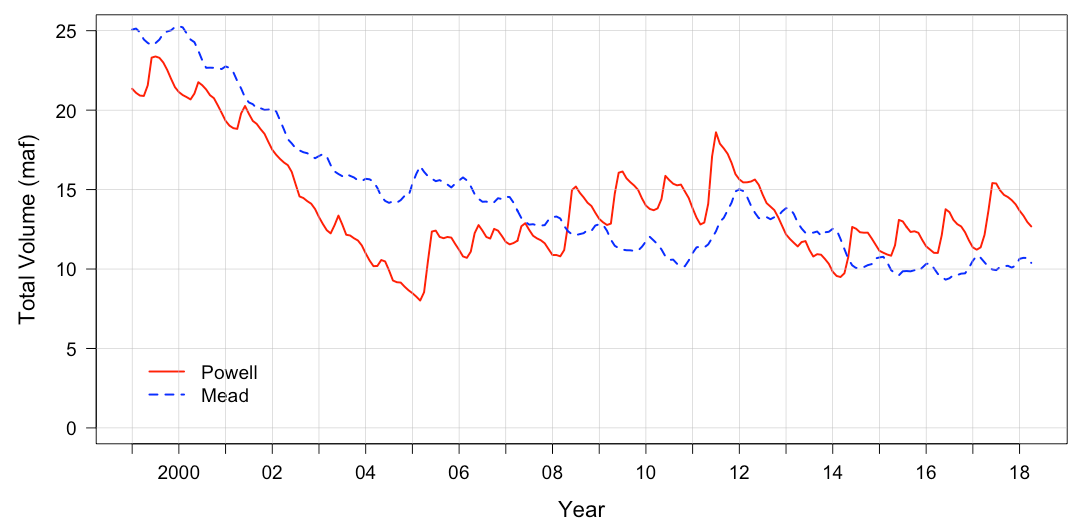
The Colorado River remains at the cutting edge of western water management, but in a different context. The challenge today has been described as “undevelopment,” a term used to acknowledge that the most pressing need in the basin is to reform infrastructure and for institutions to encourage fewer water withdrawals and less consumption. At the heart of this challenge is the observation that consumption in recent years has exceeded natural inflows, an inherently unsustainable approach to water management made possible only by drawing down the huge storage reservoirs in the basin (see fig. 6.1).
The Law of the River significantly over-allocates the river, a problem derived by two climate-related surprises. The first happened in the negotiation of the 1922 compact, when negotiators had access to only a couple decades of streamflow measurements to estimate average flows. With the benefit of hindsight, we now know that was one of the wettest periods in the basin’s history, leading the negotiators to seriously overestimate the amount of water available for allocation—a problem compounded by assigning fixed quantities rather than percentages to each basin (a problem avoided in most future interstate compacts) (Meko et al. 2007). The compact allocates the rights to 7.5 million acre-feet (maf) per year of consumption to both the Upper and Lower Basin, while the 1944 treaty reserves an additional 1.5 maf/year for Mexico. This total, 16.5 maf, far exceeds the twentieth-century average streamflow of just under 15 maf/year. This problem was only a problem on paper until actual consumption climbed past 15 maf/year, right at the turn of the twenty-first century. The new century brought the second climate-related surprise: a rash of drought years, combined with newly raised temperatures, that further sapped the flow of the river. Thus far in the twenty-first century, the flow of the Colorado is approximately 12 maf/year, 20% below the twentieth-century average (Xiao et al. 2018). While it is certainly possible that this trend will reverse, there is a rapidly growing body of science suggesting that this is likely not a drought but a persistent drying trend, described by Colorado River Research Group (2018) as “aridification.”
The challenge facing the Colorado is one that is likely to become the norm in the West: How can institutions and infrastructure built on the premise of encouraging and facilitating water consumption be retooled to encourage conservation? Unlike previous water management challenges in the basin, this is not primarily an engineering challenge; those are easy. Rather, the Colorado River is awash in equity problems (Robison and Kenney 2013). For example, the Lower Basin states use more than their 7.5 maf allocation, while the Upper Basin states use less. Given that, it is hard to demand conservation from the Upper Basin users, even if the Lower Basin uses generate the majority of economic benefits in the basin. That was not the deal codified in the compact. If the Lower Basin users can succeed in efforts to scale back to 7.5 maf/year (something they are actively working on), then that presumably frees up water that Upper Basin users have every legal right to use, thereby negating the system benefits of water conservation. Is it fair to stop these new Upper Basin uses? Going further, municipal water use is much more economically valuable than irrigation uses and serves the population centers where the vast majority of basin residents reside. Does that mean that irrigators should bear the brunt of looming curtailments, even though they are growing crops that sustain those urban residents, and even though they were the first users of water in the basin? Actually, to that point, they were not the first users. The Law of the River is nearly absent in reserving water for the environment, and while the rights of Native American communities are now well established in law, many communities still lack access to water. How can these oversights be remedied if the pressing need is to accomplish net reductions in consumption?
One recent effort to better understand the challenges and potential solutions was the Colorado River Basin Water Supply and Demand Study, an ambitious technical investigation led primarily by the Bureau of Reclamation, US Department of the Interior (2012). The study used a variety of water demand and water supply scenarios (one of which included climate change projections) to estimate future imbalances should no significant actions be taken. Those results quantified not only the growing magnitude of the supply/demand imbalance, but also the difficultly in identifying a clear vision for what a sustainable future might look like. The study highlighted that each water user group has different levels of water security, risk thresholds, and risk management opportunities, and these shift depending on the water management behavior of other water users. This shift results from many forces, ranging from the age of the water use (and its intrastate priority), the physical location of the water use (as well as the location of infrastructure), the economic resources of the water user, and the specifics (and specific errors) in the allocation framework documents. It is a heterogeneous collection of water users. The fate of all water users may be intertwined, but we are not all in this together.
Lacking a unified vision about what management regime is truly sustainable or equitable, organizing collective action is difficult. Despite this reality, however, Colorado River management has changed dramatically in the last fifteen years. Increasingly, stakeholders are opting for cooperation and negotiation over polarization and litigation. The decision-making tent is slowly expanding to include environmental interests and, to a lesser extent, Native American tribes. Negotiations are occurring at virtually every scale—substate, interstate, basin-wide. There is some reason for optimism. Whether or not these processes can lead to solutions at a pace sufficient to avoid catastrophic shortages, however, remains in doubt. Should the water delivery system “crash,” then clear winners and losers will emerge, and the opportunity for cooperative problem solving may dry up completely.
Water, Land, and the Road Forward
Notably absent from the preceding discussion of the unfolding Colorado River crisis was its link to public lands and public resources. Those links certainly exist, but with few exceptions, water management regimes are typically developed independently of public land and resource management. Rather, management is almost entirely focused on the withdrawal of water to meet human uses—uses that occur primarily on private lands. The exceptions to this rule are important. On the Colorado, the main exceptions revolve around hydropower generation and, more generally, the relationship between the big dams on the system and the functioning of the river corridors downstream (Adler 2007). Perhaps the best example on the Colorado is the Grand Canyon, immediately downstream of Glen Canyon Dam. Since 1996, the Glen Canyon Dam Adaptive Management Program has tried to balance the largely incompatible objectives of river regulation and the environmental and recreational values associated with Glen Canyon National Park and Glen Canyon National Recreation Area (Schmidt et al. 1998). Similar, but much more pronounced, struggles have shaped water management in other regions of the West, especially the Northwest, where competing goals of power production and salmon recovery have tormented resource managers for decades (National Resource Council 1996). These long-standing conflicts between human and environmental instream uses will continue to be a feature of western water management, but looking forward, the primary battlegrounds will lie well beyond the actual stream corridors and begin only after the water has left the channel.
The nature of these conflicts is shaped by two parameters: jurisdictions and sectors. At the macroscale, most of the large western rivers have been allocated among the relevant basin states, a first step in dividing up the flow among increasingly finer jurisdictions, such as districts, municipalities, and, ultimately, individual properties and users. This is primarily what western water law is designed to accomplish. For all the benefits that this achieves, these allocation processes have undermined the integrity of western rivers—every bit as much as the concrete and steel infrastructure—as the conception of a river as a whole, intact living body is lost. Also lost, in many cases, is the sense of a river basin community, as each jurisdiction (and sub-jurisdiction) is its own entity with its own rights and own risk portfolio. In other words, if I’m in a better position than my neighbor, then I may be sympathetic, but it’s ultimately not my concern.
This leads to the second parameter: sectors. Among human water users, there are two primary players: irrigators and municipal and industrial water users. The numbers vary from state to state, but generally at least 70% of human water consumption (and often much more) in the West occurs in agriculture, whereas the vast majority of people and economic activity are concentrated in cities. Again, the linkages between the two sectors are tight; farmers provide city dwellers with food and open spaces, while cities provide the revenue and services needed by rural populations. As water becomes scarcer across the West, however, the two sectors are increasingly in competition. Skillfully managing that conflict has become the front line in water management, and arguably among the biggest challenges in the West overall.
To be clear, the conflict is not between farmers and cities; rather, it is between rural areas and cities. To the extent that farmers “lose” water to cities, it is normally because they have chosen to sell their rights, often at prices that handsomely reward the farmer. These are voluntary arrangements. To the extent that there is a victim in these stories, it is the broader rural community, and specifically those individuals whose livelihoods and budgets depend on farmers buying materials and services associated with irrigated agriculture (National Research Council 1992). These are the invisible players in existing systems of water rights. As seen in places like Crowley County, Colorado, when the farmers sell their water rights, the communities literally dry up and disperse as winds scour barren fields and abandoned homes and businesses (Devine 2015). This process is known as buy-and-dry, and it is the widely feared result of the trajectory emerging in many basins, including much of the Colorado River Basin.
Is there an alternative? One alternative is urban water conservation. If a city can meet the water demands associated with population growth by conserving water, then the pressure on rural areas is avoided. There are many reasons to think this can be done. The major cities of the West—including Albuquerque, Denver, Las Vegas, Los Angeles, Phoenix, San Francisco, Seattle, and many others—use roughly the same amount (or less) of water today than they did several decades ago, despite having some of the most rapidly growing populations in the country (Colorado River Research Group 2015). That is a tremendous (and largely unknown) success story, but at least two caveats are in order. First, conservation is likely to get progressively more difficult (and expensive), as the easy opportunities have been targeted first. Second, even if total water demands are kept flat, the extremes associated with a changing climate provide a strong incentive for further expanding water systems (and water rights) to buffer expected drought conditions—including potential “megadroughts” lasting several decades (Ault et al. 2016). Conservation in the agricultural sector is another option, but one with its own complications. In many locations, such as the Colorado River Basin, farmers have been highly successful in using water more efficiently, that is, getting increasingly larger yields from an unchanged level of water consumption (Bureau of Reclamation, US Department of the Interior 2015). That is encouraging, but much like the urban success story, this is not a net reduction in use, which is ultimately what is needed in the Colorado and other western basins. In most cases, actually reducing water consumption in the agricultural sector requires taking land out of production, an outcome that is problematic to rural economies and that can also trigger the “use it or lose it” tenets of western water law, which say that a water right that is not fully used can be reduced accordingly. Many of those rules are being revised in statehouses around the West, but the fear of harming a water right—often the most valuable asset that a farmer owns—remains a serious conservation deterrent.
One potential solution is a class of evolving relationships known as alternative transfer methods, or ATMs (Colorado Water Conservation Board 2012). In a nutshell, these are deals that call upon farmers to temporarily reduce water consumption, usually by a rotational fallowing, with the conserved water going to an urban user who compensates the farmer for any lost crop yields. Some arrangements are ongoing, while others may function only in drought years or other special circumstances where city water systems are under stress. In theory, such arrangements can bolster the reliability of city water systems, while maintaining sufficient farming activities and revenues to sustain rural economies. Such arrangements are evolving across the West, particularly in Southern California, and in the case of the recent Colorado Water Plan, they have been identified as a desirable solution to looming water shortages. A host of legal, technical, and cultural obstacles have slowed widespread ATM adoption, but there are ample reasons to think that they are the right path forward.
Conclusion
To say that water scarcity is the defining characteristic of water management in the West is not a bold statement, and on the surface, it is not any different than the assessments readily found in reports from the region’s homesteading era. But important differences exist. Unlike earlier times, the challenge today is not primarily one of applying engineering to increase supplies, that is, of harnessing and diverting rivers to serve awaiting fields and growing towns. In almost all western subbasins, that work has been done, and those opportunities are exhausted. The challenge today is to cap, or even reduce, the consumption for water. As illustrated by the Colorado River case study, limiting or reducing water consumption raises a host of legal and technical issues, as well as issues better described as socioeconomic and cultural. The world of western water management is getting more complicated in many ways, including the growing influence of climate change on rivers and water delivery systems. The traditional linear practice of using historical records to statistically describe flow regimes, and to then size and build appropriate infrastructure and institutions, is largely antiquated. While we cannot precisely say what the future will look like, it almost certainly will not look like the past or the present. This places a premium on regimes that emphasize risk management and adaptive management.
Overlying all of this is the observation that the relationship between water management and land management will also likely need to evolve. The traditional notion that water development is a necessary precursor to land development and economic expansion is not necessarily invalid, but is now much too simplistic. Today, a failure to innovate in the water sector may not merely close the door to future expansion, but it also may threaten the viability of existing economies and communities. Just maintaining the status quo is, in many cases, a formidable achievement. Additionally, there are many reasons to think that the best opportunities for economic growth may lie in industries and activities that do not require additional water, or that depend on leaving water undistributed instream. The best paths to prosperity in the New West will likely be those that emphasize water resource protection and conservation, not development and consumption. For many in the water resources community, this is new territory.
References
Adler, Robert. 2007. Restoring Colorado River Ecosystems: A Troubled Sense of Immensity. Washington, DC: Island Press. (↵ Return)
Ault, Toby R., Justin S. Mankin, Benjamin I. Cook, and Jason E. Smerdon. 2016. “Relative Impacts of Mitigation, Temperature, and Precipitation on 21st-Century Megadrought Risk in the American Southwest.” Science Advances 2 10): e1600873. (↵ Return)
Bureau of Reclamation, US Deparment of the Interior. 2012. Colorado River Basin Water Supply and Demand Study. Washington, DC: Bureau of Reclamation, Department of the Interior. https://www.usbr.gov/watersmart/bsp/docs/finalreport/ColoradoRiver/CRBS_Executive_Summary_FINAL.pdf. (↵ Return)
Bureau of Reclamation, US Department of the Interior. 2015. Colorado River Basin Stakeholders Moving Forward to Address Challenges Identified in the Colorado River Basin Water Supply and Demand Study.. Phase 1 Report: Executive Summary. Washington, DC: Bureau of Reclamation, US Department of the Interior. https://www.usbr.gov/lc/region/programs/crbstudy/MovingForward/Phase1Report/fullreport.pdf. (↵ Return)
Cayan, Daniel R., Michael D. Dettinger, David Pierce, Tapash Das, Noah Knowles, F. Martin Ralph, and Edwin Sumargo. 2016. “Natural Variability, Anthropogenic Climate Change, and Impacts on Water Availability and Flood Extremes in the Western United States.” In Water Policy and Planning in a Variable and Changing Climate, edited by Kathleen A. Miller et. al., 17–42. Boca Raton, FL: CRC Press. (↵ Return 1) (↵ Return 2) (↵ Return 3)
Cohen, Michael J. 2011. Municipal Deliveries of Colorado River Basin Water. Oakland, CA: Pacific Institute. http://pacinst.org/publication/municipal-deliveries-of-colorado-river-basin-water-new-report-examines-100-cities-and-agencies/. (↵ Return 1) (↵ Return 2)
Cohen, Michael J., Juliet Christian-Smith, and John Berggren. 2013. Water to Supply the Land: Irrigated Agriculture in the Colorado River Basin. Oakland, CA: Pacific Institute. http://pacinst.org/publication/water-to-supply-the-land-irrigated-agriculture-in-the-colorado-river-basin/. (↵ Return 1) (↵ Return 2)
Colorado River Research Group. 2015. “The Case for Conservation.” May 2015. https://scholar.law.colorado.edu/cgi/viewcontent.cgi?article=1174&context=books_reports_studies. (↵ Return)
Colorado River Research Group. 2018. “When Is Drought Not a Drought? Drought, Aridification, and the “New Normal.”” March 2018. https://www.coloradoriverresearchgroup.org/uploads/4/2/3/6/42362959/crrg_aridity_report.pdf.
Colorado Water Conservation Board. 2012. Alternative Agricultural Water Transfer Methods Grant Program Summary and Status Update. Technical Memorandum. Denver, CO: CDM Smith. (↵ Return)
Devine, Brian. 2015. “The Legacy of Buy‐and‐Dry and the Challenge of Lease‐Fallowing in Colorado’s Arkansas River Basin.” Master’s thesis, University of Colorado, Boulder. (↵ Return)
Fradkin, Philip L. 1981. A River No More. Tucson: University of Arizona Press. (↵ Return)
Hansen, J., R. Ruedy, M. Sato, and K. Lo. 2010. “Global Surface Temperature Change.” Reviews in Geophysics 48: RG4004. https://doi.org/10.1029/2010RG000345. (↵ Return)
Intergovernmental Panel on Climate Change. 2013. Climate Change 2013: The Physical Science Basis. Contribution of Working Group I to the Fifth Assessment Report of the Intergovernmental Panel on Climate Change, edited by T. F. Stocker et al. Cambridge: Cambridge University Press. https://doi.org/10.1017/CBO9781107415324. (↵ Return)
Kenney, Douglas S. 2014. “History of River Governance in the United States.” In Sustainability in River Basins, edited by A. Dehnhardt and U. Petschow, 109–34. Munich: Oekom. (↵ Return)
Lukas, Jeff, Joseph Barsugli, Nolan Doesken, Imtiaz Rangwala, and Klaus Wolter. 2014. Climate Change in Colorado: A Synthesis to Support Water Resources Management and Adaptation. A Report for the Colorado Water Conservation Board. University of Colorado, Boulder. (↵ Return)
MacDonnell, Lawrence J., David H. Getches, and William C. Hugenberg Jr. 1995. “The Law of the Colorado River: Coping with Severe Sustained Drought.” Water Resources Bulletin 31 (5): 825–36. (↵ Return)
Meko, David M., Connie A. Woodhouse, Christopher A. Baisan, Troy Knight, Jeffrey J. Lukas, Malcolm K. Hughes, and Matthew W. Salzer. 2007. “Medieval Drought in the Upper Colorado River Basin.” Geophysical Research Letters 34 (10): 1–5. https://doi.org/10.1029/2007GL029988. (↵ Return)
Milly, P. C. D., Julio Betancourt, Malin Falkenmark, Robert M. Hirsh, Zbigniew W. Kundzewicz, Dennis P. Lettenmaier, and Ronald J. Stouffer. 2008. “Climate Change: Stationarity Is Dead; Whither Water Management?” Science 319(5863): 573–74. (↵ Return)
National Research Council. 1992. Water Transfers in the West: Efficiency, Equity and the Environment. Washington, DC: National Academy Press. (↵ Return)
National Research Council. 1996. Upstream: Salmon and Society in the Pacific Northwest. Washington, DC: National Academies Press. (↵ Return)
Powell, John Wesley. 1878. Report on the Lands of the Arid Region of the United States, with a More Detailed Account of the Lands of Utah. Washington, DC: Government Printing Office. (↵ Return)
Reisner, Marc. 1986. Cadillac Desert: The American West and Its Disappearing Water. New York: Penguin. (↵ Return)
Revelle, R. R., and P. E. Waggoner. 1983. “Effects of a Carbon Dioxide Induced Climatic Change on Water Supplies in the Western United States.” In Changing Climate, 419–32. Washington, DC: National Academy of Sciences Press. (↵ Return)
Robison, Jason, and Douglas S. Kenney. 2013. “Equity and the Colorado River.” Environmental Law 42(4): 1157–209. (↵ Return)
Schmidt, John C., Robert H. Webb, Richard A. Valdez, G. Richared Marzolf, and Lawrence E. Stevens. 1998. “Science and Values in River Restoration in the Grand Canyon.” BioScience 48(9): 735–47. (↵ Return)
Sproles, E. A., A. W. Nolin, K. Rittger, and T. H. Painter. 2013. “Climate Change Impacts on Maritime Mountain Snowpack in the Oregon Cascades.” Hydrology and Earth System Sciences 17: 2581–97. https://doi.org/10.5194/hess-17-2581-2013. (↵ Return)
Stegner, Wallace. 1954. Beyond the Hundredth Meridian: John Wesley Powell and the Second Opening of the West. New York: Penguin. (↵ Return)
Udall, Bradley, and Jonathan Overpeck. 2017. “The Twenty-First Century Colorado River Hot Drought and Implications for the Future.” Water Resources Research 53: 2404–18. https://doi.org/10.1002/2016WR019638. (↵ Return)
Weatherford, Gary D., and F. Lee Brown, eds. 1986. New Courses for the Colorado River. Albuquerque: University of New Mexico Press. (↵ Return)
Woodhouse, Connie A., Gregory T. Pederson, Kiyomi Morino, Stephanie A. McAfee, and Gregory J. McCabe. 2016. “Increasing Influence of Air Temperature on Upper Colorado River Streamflow.” Geophysical Research Letters 43: 2174–81. https://doi.org/10.1002/2015GL067613. (↵ Return)
Xiao, Mu, Bradley Udall, and Dennis P. Lettenmaier. 2018. “On the Causes of Declining Colorado River Streamflows.” Water Resources Research 54(9): 6739–56. https://doi.org/10.1029/2018WR023153. (↵ Return 1) (↵ Return 2)
